The National Weather Service office in Mobile has confirmed that two EF-1 tornadoes touched down in Washington County during severe weather on Sunday, adding the southwestern Alabama county to the season’s damage survey list. The confirmations came after survey teams toured the affected areas, examined the damage and rated the storms on the Enhanced Fujita scale — the standard method for estimating a tornado’s strength after the fact.
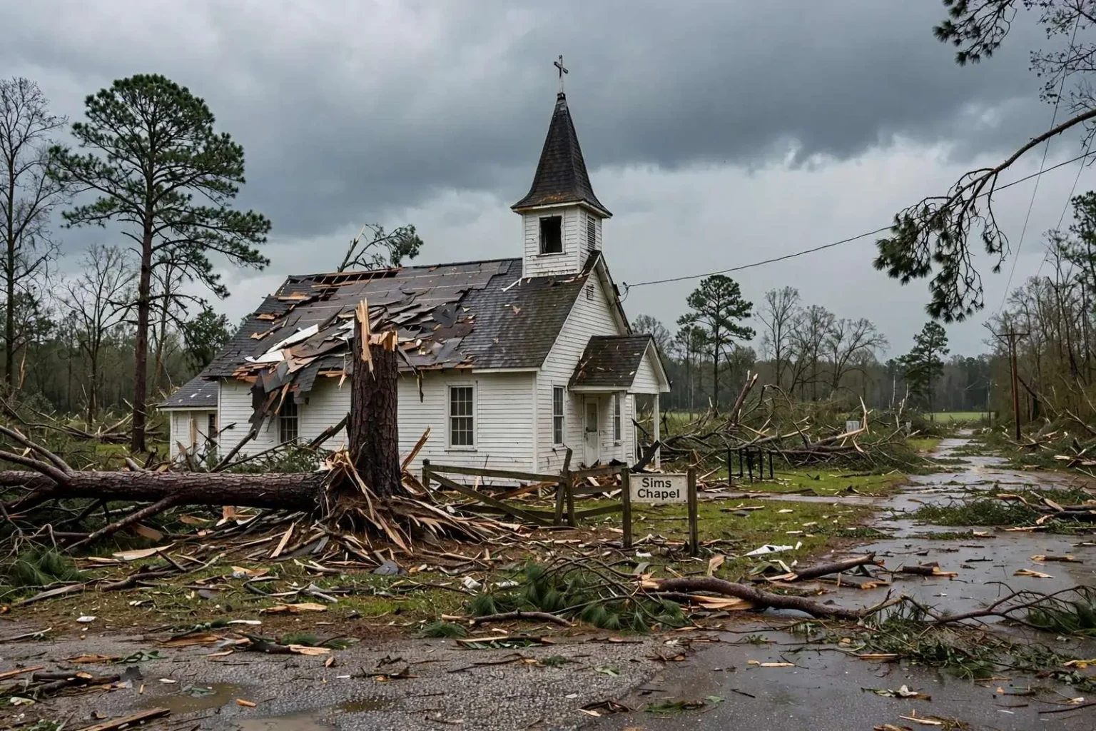
One of the twisters formed in the Sims Chapel community, where it damaged a church before lifting. The second touched down in the Chatom area, according to the weather service’s damage survey. Neither tornado was rated among the strongest classifications, but both left behind the kind of damage that residents of small Washington County communities recognize from past severe weather events: battered roofs, downed trees and scattered debris across country roads.
Survey teams rated the Sims Chapel tornado with maximum wind speeds of 105 mph, while the Chatom tornado reached maximum winds of 95 mph. Both fall within the EF-1 category on the Enhanced Fujita scale, which covers tornadoes with estimated winds of 86 to 110 mph — strong enough to peel roofing, snap or uproot trees, and shift structures from their foundations.
Reading the Damage Survey
The National Weather Service’s damage survey is the mechanism by which raw storm reports become confirmed tornado records. When severe weather crosses the forecast area, teams — often meteorologists accompanied by local emergency management personnel — drive the suspected damage paths, photograph the destruction and look for the tell-tale patterns that distinguish tornado damage from straight-line wind damage. Tornadoes leave convergent, rotational damage signatures: debris thrown in multiple directions, trees twisted rather than snapped in one plane, damage that starts and stops along a defined track.
The wind speed estimates that result are indirect. Surveyors rarely measure a tornado’s winds directly; instead, they use damage indicators — the construction type that failed and the degree of failure — to back into an estimated wind range. That is why two EF-1 tornadoes can carry different maximum wind estimates, as the Sims Chapel and Chatom storms did at 105 and 95 mph respectively: the ratings reflect the worst damage found along each track, not a continuous measurement.
The church damaged in Sims Chapel illustrates how the ratings translate to real structures. A house of worship typically features a large, open interior span with a roof system that is vulnerable to uplift once winds compromise the envelope — precisely the kind of damage consistent with winds in the 100-mph range. Damage to community institutions like churches tends to register deeply in small communities, both because of the buildings’ centrality and because repairs depend heavily on insurance, volunteer labor and donations.
The Enhanced Fujita Scale in Practice
The Enhanced Fujita scale, adopted to replace the original Fujita scale, assigns ratings from EF-0 to EF-5 based on estimated three-second wind gusts. The EF-1 band — 86 to 110 mph — is the second-lowest rating on the scale, but it is where a large share of confirmed tornadoes land. An EF-1 will not sweep a well-built house from its foundation as stronger tornadoes can, yet it routinely destroys outbuildings, strips roofs, breaks windows and fells the mature pines and hardwoods that line South Alabama’s roads.
Falling trees are, in fact, the signature hazard of modest tornadoes in forested regions like Washington County. A 95-to-105-mph wind field that might spare a home’s structure can still bring limbs and trunks down onto roofs, power lines and vehicles, and downed trees are consistently among the leading causes of injury and extended power outages in Gulf South tornado events. For rural counties, where response times are longer and utility crews cover greater distances, the cleanup after even a rated EF-1 can stretch across days.
Washington County’s Severe Weather Setting
Washington County sits along Alabama’s southwestern border with Mississippi, and its small communities such as Sims Chapel and the county seat of Chatom are no strangers to severe weather during the region’s frequent spring storm systems. The county lies within the broad swath of the Gulf South where warm, moist air from the Gulf of Mexico collides seasonally with cooler air masses moving in from the west — a collision that produces the thunderstorm complexes, squall lines and embedded tornadoes that define the region’s spring severe weather season.
The county’s geography shapes both its exposure and its response. Rural and lightly populated, Washington County is covered largely by forest, pasture and small settlements connected by state highways and county roads. When a tornado touches down near Sims Chapel or Chatom, there may be few witnesses and limited immediate reporting; damage surveys by the National Weather Service are often the first authoritative account of what occurred, and they frequently confirm tornadoes that were only suspected on the night of the storm.
Doppler radar coverage, while strong in the Mobile area, degrades in resolution at the distances of interior Washington County, and low-topped tornadoes that develop quickly can escape unambiguous radar detection. That reality makes the ground survey — and the reports from residents, sheriff’s deputies and volunteer fire departments that guide surveyors — essential to the final record. Sunday’s dual confirmation shows the process working as designed: reports came in, survey teams followed up, and two separate tornado tracks were documented and rated.
What Residents Can Take From the Confirmations
For residents, the confirmations serve several practical purposes. They establish the official record that supports insurance claims and federal assistance documentation; they refine the region’s severe weather climatology, feeding the data that shapes where tornado risk is understood to be highest; and they underscore the recurring lesson of Gulf South spring storms — that warnings matter, and that the minutes between a warning and a tornado’s arrival are the safety margin.
The National Weather Service’s Mobile office, which produced the survey, covers southwest Alabama and northwest Florida, an area that includes some of the most tornado-active territory in the United States relative to its size. The office issues warnings, conducts damage surveys and maintains the storm database into which the Sims Chapel and Chatom tornadoes will now be entered.
Chatom and Sims Chapel: Small Communities, Familiar Storms
Chatom, the county seat of Washington County, anchors local government, schools and commerce for a county whose population is among the smaller in Alabama. Communities like Chatom and Sims Chapel experience severe weather the way most rural Gulf South towns do: with volunteer fire departments as first responders, with neighbors checking on neighbors along rural routes, and with recovery dependent on local resources until county crews and utility teams can complete their work. A church damaged in Sims Chapel or roofs stripped in Chatom are not statistical entries to the people who live there; they are the town’s landmarks and gathering places.
The spring storm season that produced Sunday’s tornadoes is a familiar cycle for the county. Gulf South severe weather typically arrives in organized waves — a warm sector drawing moisture north from the Gulf, a frontal system approaching from the west, and squall lines that can produce embedded rotation with little visual warning. Forecasters often have hours of lead time for the event as a whole, but individual tornadoes within a line can develop and dissipate in minutes, which is why the National Weather Service emphasizes preparedness before the warnings rather than reaction during them.
Preparedness in rural counties carries its own specific challenges. Mobile homes, which are numerous across rural South Alabama, perform poorly in tornado winds even at the EF-1 level; long distances to shelters complicate decisions for residents outside town; and fewer warning sirens means many residents rely on NOAA weather radio, broadcast media or phone alerts for notification. The confirmations from Sunday’s storms give emergency managers in Washington County concrete data for the ongoing public education work those challenges demand.
What Comes After the Survey
With both tornadoes confirmed and rated, the immediate documentation phase gives way to recovery. Property owners with damage from the Sims Chapel or Chatom storms will file insurance claims supported by the official survey record, which establishes both the cause and the estimated wind speeds — details that matter when adjusters assess whether damage patterns are consistent with the reported event. County and state officials use the same documentation to judge whether the damage reaches thresholds for any assistance programs, though events of this scale typically fall to insurance and local resources rather than federal disaster declarations.
The survey report itself becomes part of the historical record. The complete damage survey report is available through the National Weather Service’s Mobile forecast office, which covers southwest Alabama and northwest Florida. Residents, researchers and emergency planners can review the mapped tracks, the wind estimates and the described damage — the permanent account of a Sunday that brought two confirmed tornadoes to Washington County, and the latest entry in the region’s long, well-documented acquaintance with severe weather.
For now, the communities involved turn to the familiar work of cleanup: clearing fallen trees from county roads, patching roofs before the next round of storms, and repairing a church that has anchored the Sims Chapel community through storms past. The tornadoes lasted minutes; the county’s recovery, as always, will take longer — and the National Weather Service’s confirmation ensures that what happened on Sunday will be understood, measured and remembered accurately.