Santa Rosa County Crews Clear Storm Debris From Bridges as More Rain Threatens
Santa Rosa County road crews are clearing storm debris from Coldwater Creek bridges ahead of another round of heavy rain and possible flooding.
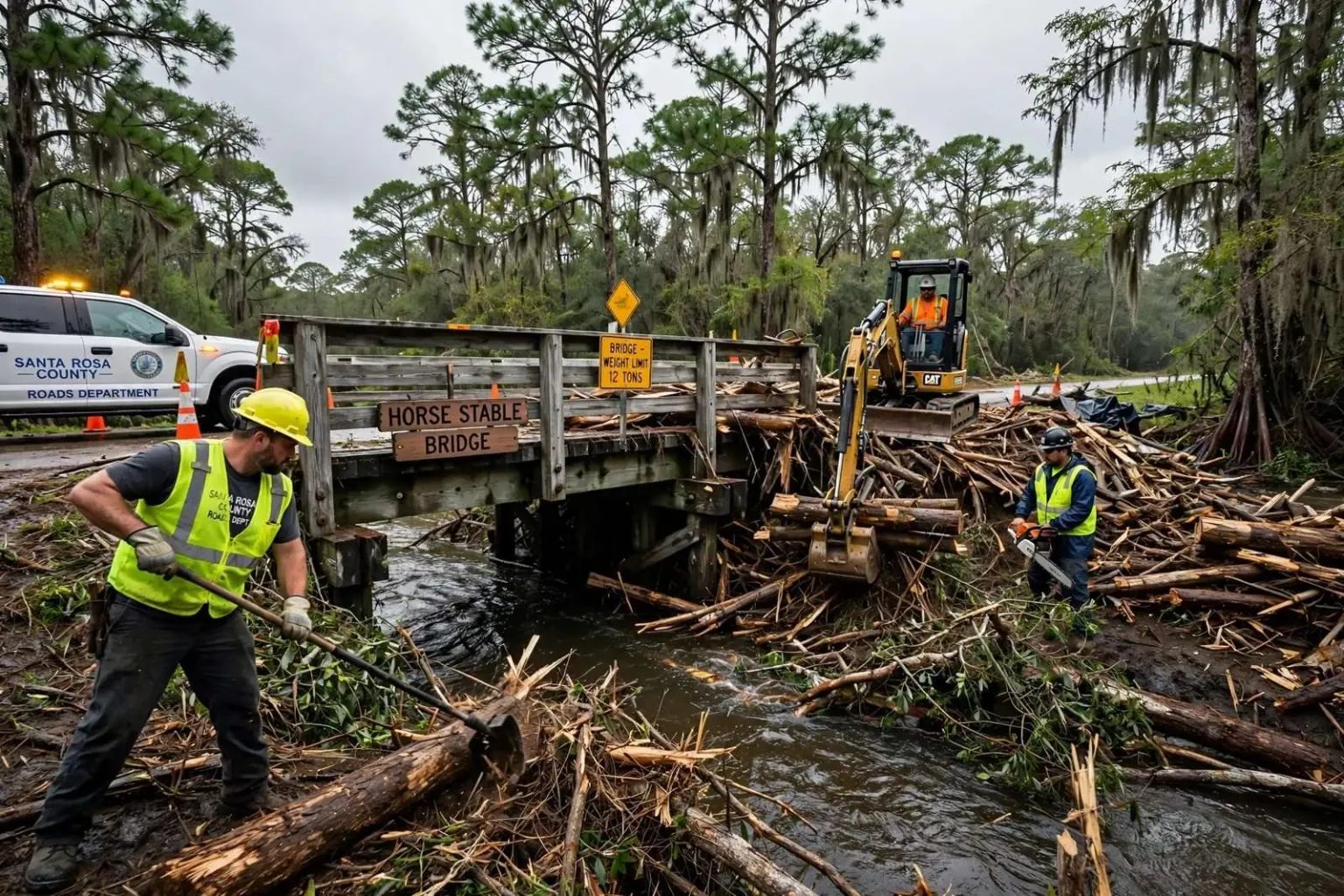
Santa Rosa County road crews have been working since dawn to clear storm debris from area bridges, racing to protect the structures before another round of rain moves in.
This weekend’s storms threw heavy debris into Coldwater Creek, and much of it piled up at the Horse Stable bridge near the state park. By Monday morning, debris covered the entire width of the creek and rose over the top of the bridge, and inspectors warned it could have damaged the pilings.
Stephen Furman with the Santa Rosa County Roads Department said crews monitor the bridges several times a day and work quickly to keep material from accumulating.
“We try to keep material off [the] bridge quickly and as much as we can so it doesn’t put too much pressure on [the] bridge,” Furman said. Crews reached as far upstream as they could, stockpiling debris before it could drift back down into the structure.
Furman explained the danger: when too much material catches on a bridge, both the force of the water and the sheer weight of the debris can cause the span to shift. So far, the Horse Stable bridge does not appear to have suffered major damage, but officials want the water low enough to test the pilings before more rain arrives.
The ground across the county is already saturated and some areas remain flooded. With the National Weather Service forecasting an additional three to four inches of rain, Furman cautioned that places that escaped the first round of flooding could see worse conditions in the days ahead.
The Engineering Behind Bridge Debris Loading
Coldwater Creek drains one of the wildest stretches of Santa Rosa County — a blackwater stream that rises in the longleaf pine flatwoods of the northern county and runs south through the swamps of what is now the Blackwater River State Forest toward the East Bay. The creek is beloved by paddlers for its white sand bars and swift, tea-colored current, and by the county’s emergency managers for a very different quality: it responds to rain faster than almost any waterway in the region. A narrow, sandy-bottomed channel with a broad watershed means a heavy rain event hundreds of feet of elevation upstream can send a wall of water and debris downstream within hours, and the same current that makes the creek a favorite of kayakers gives floating trees, fencing, and construction debris the momentum to do real damage when it meets a bridge.
The mechanics of debris accumulation on a bridge — what Furman’s crews spent the week fighting — are a recognized hazard in hydraulic engineering. A spanning log or floating mass that catches on a pier or the span’s underside collects more material at a rate that accelerates as the blockage grows: the accumulated raft slows the water flowing through the remaining opening, which backs water up, which raises the depth and force of flow against the bridge, which catches more debris. Engineers call the resulting force “debris loading,” and it is counted among the leading causes of bridge failure in flood events nationwide — not because the water overwhelms the structure alone, but because a waterway’s whole storm-load of timber can end up leaning on a single set of pilings.
The crews’ strategy — monitoring several times a day, clearing material as it arrives, and hauling debris upstream to stockpiles — reflects the practical playbook for managing that risk. Once a blockage matures, heavy equipment working from the bridge itself can be both ineffective and dangerous, since the accumulated mass becomes unstable and the current beneath it remains powerful. Clearing material early, before it consolidates, keeps each load small and each work session safe. The upstream stockpiling Furman described serves a second purpose: debris dumped on the bank below the flood line stays put, while debris left at the water’s edge simply rejoins the current on the next rise.
Inspecting the pilings for hidden damage is the step that will determine whether the Horse Stable bridge escapes the event unscathed. A bridge can look intact above the waterline while scour — the erosion of sediment around and beneath the pilings by fast, constricted flow — has undermined its footings below. Scour is the leading cause of bridge failure in the United States, and inspectors look for it whenever a bridge has carried a heavy debris load or sustained high water: the concern is not only the pile of logs visible above the surface but the holes the diverted current may have carved where no one can see. That is why officials want the creek to drop before certifying the structure, and why a bridge that has shrugged off one flood can still be closed if inspectors find the ground has been pulled out from under it.
Saturated Ground Raises the Flood Risk
The saturated ground across the county set the stage for everything the forecast promised. Soils that are already full of water cannot absorb the next rain, which means each new storm sends a larger share of its rainfall directly into creeks and rivers — faster runoff, higher crests, and flooding at lower rainfall totals than the same storm would produce on dry ground. That hydrology is why emergency managers watch not just the forecast but the memory of the ground: a system that would be unremarkable in August’s normal conditions can produce record flooding when it arrives on soils that are already soaked, and areas that stayed dry in the first round have no guarantee of doing so in the second.
The three to four additional inches the National Weather Service forecast for the county falls in the range that turns a flood event into a prolonged one. On the Blackwater and Coldwater systems, that kind of rain keeps creeks above bankfull for days, prolonging the debris threat to every bridge and culvert on the system and stretching the county’s road crews across a longer front. Low-water crossings and older culverts — the quiet workhorses of the county’s rural road network — are typically the first to fail, and the county’s practice during multi-round rain events is to close roads preemptively rather than risk drivers on structures whose condition is changing by the hour. Barricades that go up in a morning can stand for days, a disruption that residents of the county’s rural north know as the recurring price of living on a flood-prone landscape.
The work crews like Furman’s do during these events rarely makes news unless a bridge fails, and that is the point: the hours of monitoring, the backhoes working the banks at dawn, the logs winched off a span before they can consolidate — all of it is prevention, measured in bridges that stay open and creeks that flow through rather than over. For a county that sits on some of the fastest-responding waterways in the Florida Panhandle, the routine that followed this weekend’s storms is not an emergency response so much as the standing discipline of a roads department that knows its creeks: watch them closely, clear them early, and never let a flood decide what a bridge can carry.
Why the Creek Corridor Matters Beyond the Road
The Horse Stable bridge and its neighbors on the Coldwater system carry a meaning beyond their function on the road map. The creek’s corridor through the state park and the state forest is one of the county’s recreational centerpieces — the paddling trail, the sandbars, and the spring-fed swimming holes draw visitors from Pensacola and beyond throughout the warm months, and the bridges that cross the creek are the access points that make the corridor reachable. When a storm damages one, the loss registers twice: once for the residents who rely on the road, and again for the economy of outfitters, campgrounds, and day visitors whose season depends on the creek staying open to the public.
The storms that loaded the creek with debris are part of a pattern that Panhandle emergency managers have learned to plan around. The region’s late-spring and summer rain events — training thunderstorm complexes that park over the same watershed for hours — produce flood crests that arrive with little of the warning lead time that hurricanes provide. County emergency operations monitor the National Weather Service’s river gauges on the Blackwater system in real time during such events, and the gauges on Coldwater Creek itself give the first signals of how fast the water is rising. Crews like Furman’s work within that monitoring loop: the same rain forecasts that prompt residents to move vehicles and valuables prompt the roads department to stage equipment at the bridges most likely to catch debris.
Flooding’s Uneven Toll Across the County
Flooding’s uneven geography across the county shapes who floods first. The low-lying neighborhoods along the creeks and the East Bay shorelines take water first and hold it longest, while the higher ground of the central county and the fast-draining sands near the coast may see nothing worse than a swollen ditch. The result, in a multi-round rain event, is a rolling map of impact: areas flooded in the first round drain slowly through saturated ground while the second round re-fills the channels, and residents of neighborhoods that drained quickly can be caught out by water that arrives with no warning from their own experience. Furman’s caution — that places which escaped the first round could see worse conditions — is the standard message from county emergency management in exactly these situations, delivered in the hope that it moves cars and people before the water does.
Road departments along the Gulf Coast maintain standing debris contracts and mutual-aid arrangements for exactly this kind of event. Clearing a creek-wide debris raft requires heavy equipment, haul trucks, and disposal sites, and the volume generated by a single storm on a wooded watershed can overwhelm a county’s own crews. The stockpiling Furman described creates its own logistics: debris hauled from the water’s edge must be sorted — vegetation, construction material, household items — and taken to sites that can handle each stream. In events that qualify for state or federal assistance, that documentation becomes the basis for reimbursement, which is one more reason crews photograph and tally their work as they go, even while the rain is still falling.
The week’s work on Coldwater Creek will fade from the news long before the county forgets its lessons. Every flood leaves behind a revised map in the minds of the people who manage the county’s infrastructure: which bridges catch debris, which roads flood first, which culverts need upsizing before the next storm. Crews like Furman’s carry that memory in their routines — the bridges they check first when the forecast turns, the reaches of creek where a stockpile can be built, the equipment staged where it can reach a crossing before the water cuts it off. That accumulated knowledge is the county’s real flood defense, and it is renewed one storm at a time, one bridge at a time, by the people who show up at dawn after the rain to see what the creek has left behind.