University of South Alabama Bayou La Batre
Forecasters Told the Gulf Coast to Expect a Busier Than Normal Hurricane Season
A University of South Alabama meteorologist relayed word that the 2008 hurricane season would likely run above normal, with elevated odds of a major hurricane striking the Gulf Coast.
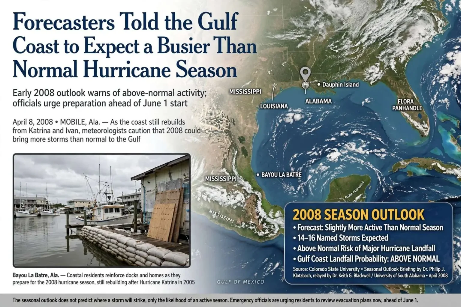
Two months before the start of the 2008 hurricane season, the early word reaching the Alabama coast was not reassuring: the year ahead looked busier than average, and the odds of a major hurricane coming ashore on the Gulf of Mexico were running above normal. The early outlook, arriving while the coast was still recovering from two catastrophic seasons, set the tone for a year in which preparation, not luck, would be the region’s best policy.
The assessment came from Dr. Keith G. Blackwell, associate professor of meteorology at the University of South Alabama, who reported that he had just been briefed by Dr. Philip J. Klotzbach — the researcher chosen by the veteran Colorado State University forecaster Dr. William M. Gray to carry on his seasonal hurricane prediction work. Blackwell, whose forecasts and storm analyses are followed along the northern Gulf coast, had long been the conduit through which the Colorado State outlooks reached Alabama’s emergency management community.
“Just got a briefing this past weekend from Dr. (Philip J.) Klotzbach,” Blackwell said. “He indicates that the 2008 season will likely be slightly more active than normal. Major hurricane landfall probabilities on the Gulf coast will also be above normal.” Klotzbach’s official forecast was expected in early June, at the opening of the season, when the April outlook’s numbers would be revised with the winter’s final atmospheric data.
Why the Gray forecasts mattered here
For decades, the Colorado State University seasonal outlooks — associated above all with William Gray, who pioneered the practice of forecasting an entire hurricane season months in advance — were among the first numbers that coastal Alabama looked at each spring. Gray’s forecasts, built on Atlantic sea-surface temperatures, wind patterns and the behavior of the El Nino cycle, launched a discipline that now includes government agencies and private firms, and his April and June outlooks became fixtures of coastal news coverage from Texas to Florida.
They do not predict where a storm will strike. What they estimate is activity: how many named storms, how many hurricanes, how many majors, and the statistical likelihood that at least one of them will reach a given stretch of coastline. A forecast can say the deck is stacked; it cannot say which card comes off the top. That distinction — between an active season and a struck one — is the first lesson every emergency manager learns about seasonal outlooks.
By April 2008, that abstraction carried a good deal of weight along Mobile Bay. Hurricane Ivan had come ashore near Gulf Shores in September 2004, and Hurricane Katrina had pushed a devastating surge into Bayou La Batre, Coden and Dauphin Island in August 2005. Communities in south Mobile County were still rebuilding when the 2008 outlooks began circulating — homes on pilings rising along the Bayou La Batre waterfront, a shrimping fleet slowly restored, and stretch of Dauphin Island’s west end that had been literally redrawn by Ivan and then battered again by Katrina.
In Bayou La Batre, the storm remained the dividing line in local conversation between before and after. The seafood town of roughly 2,300 people had lost boats, docks, homes and businesses to Katrina’s surge, and the federal recovery money that rebuilt its harbor and housing was still flowing three years later. Residents there did not need a statistician to explain what an above-normal season meant; their property lines and family albums carried the argument.
An above-normal year, in context
“Slightly more active than normal” is the kind of phrase that reads as mild until it is translated into practice. A normal Atlantic season produces roughly a dozen named storms; an active one produces more, and each additional storm is another chance that the steering currents will carry it into the northern Gulf. The Gulf’s geography concentrates the risk: its warm, shallow waters intensify storms rapidly, and its coastline curls around the entire storm track from Texas to Florida, leaving no landfall scenario that spares somebody on the shore.
The more consequential half of Blackwell’s report was the second sentence — that major hurricane landfall probabilities on the Gulf Coast were also expected to run above normal. Major hurricanes, meaning Category 3 and above, are the storms that produce the surge that reshapes a coastline. It is surge, not wind, that has historically killed the most people in Gulf storms, and it was surge — twenty feet of it in places in 1969’s Hurricane Camille, and up to twenty-five feet in Katrina — that had done the damage along the Mississippi Sound in 2005.
The distinction matters for planning on the Alabama coast. A Category 1 storm threatens mobile homes, low-lying roads and the utilities that serve the barrier island; a major hurricane threatens everything from Gulf Shores to downtown Mobile. Emergency planning is built around that gap: evacuation zones are drawn to move the people behind the surge line first, and the worst-case categories extend the line miles inland, up Mobile Bay and into the river deltas.
What the season required
The seasonal outlook was, in the end, an argument for preparation rather than alarm. Emergency managers in Mobile and Baldwin counties had spent the years since Katrina refining evacuation routes, shelter capacity and the mechanics of moving people off Dauphin Island and out of the low-lying communities along the Mississippi Sound. The single bridge onto Dauphin Island and the two-lane highways feeding the peninsula made the island’s evacuation among the most time-sensitive on the coast, and the state’s plans for reversing lanes on Interstate 65 — tested in the 2004 and 2005 evacuations — had become a template for moving hundreds of thousands of people inland at once.
Shelter planning had changed as well. Katrina had shown that shelters must be prepared to operate for days rather than hours, and that people who ride out a storm in a Mobile evacuation shelter may have nothing to return to. The years after 2005 brought new emphasis on re-entry procedures — how and when residents are allowed back onto the barrier islands — and on the recovery machinery that begins the moment the storm passes.
The forecasters were telling them, in early April, that 2008 would be a year to have those plans ready. The season would open June 1 and run through November 30, and Klotzbach’s formal numbers would arrive as it began. Between the April briefing and the June forecast lay the window in which the coast’s institutions — schools, hospitals, industries and the two counties’ emergency agencies — would restock and rehearse.
Coastal residents did not need a research meteorologist to tell them what a busy season could mean. But they did need a reason to check the batteries, the plywood and the evacuation plan in April instead of in August — and this year, they had one. The Colorado State outlooks had given the Gulf Coast the same gift every spring: a two-month head start on whatever the tropics would send.
The science behind the outlook
The Colorado State outlooks that Blackwell transmitted were built on measurable precursors. A weakening La Nina in the Pacific, warmer-than-normal sea-surface temperatures in the tropical Atlantic, and low wind shear across the main development region all pointed toward more storms than the 1950-2000 average, and Klotzbach’s April briefing distilled those signals into the numbers that Blackwell passed along the coast. The team would issue a June update and further revisions in August, each tightening the estimate as the season’s actual conditions came into view.
Gray’s career had established that seasonal forecasting was possible at all — a proposition that was contested when he began publishing in the 1980s and is now the backbone of every government and private seasonal outlook. The forecast’s most useful product for emergency managers is not the storm count but the landfall probability: the odds, however rough, that a major hurricane strikes a given 50-mile stretch of coast in a given year. Those numbers feed directly into stockpile decisions, staffing plans and the pre-season public messaging campaigns that counties run each May.
The season that followed
The 2008 season, as it turned out, delivered what the spring outlook promised. It produced sixteen named storms, eight hurricanes and five major hurricanes — numbers well above the long-term average — and the Gulf was struck twice in September: Hurricane Gustav came ashore in Louisiana and put coastal Alabama under evacuation orders and tropical-storm conditions, and Hurricane Ike sent a record surge up the bay that flooded homes around Mobile Bay and cut off Dauphin Island’s west end for a time.
Ike’s surge in particular vindicated the pre-season warnings. Communities that had rebuilt after Katrina above the surge line rode the September storm out; structures at the old elevations flooded again. The experience reinforced the lesson that Blackwell and the Colorado State team had been arguing all spring: the seasonal outlook cannot say which storm will come, but it can say with confidence when the coast should be ready.
April as a working month
For the counties’ emergency agencies, an early forecast converts April and May into working months: public-awareness campaigns, school and hospital drills, generator tests, and the inventory checks that make hurricane season a managed event rather than a surprise. Local media amplify the outlook every spring, and insurance and utility companies time their own preparation notices to it.
The routine was hard-won. The consecutive catastrophe seasons of 2004 and 2005 — Ivan, Dennis, Katrina — had exposed every weakness the coast had, from shelter capacity to the vulnerability of the causeways and bridges that carry evacuation traffic. By 2008 the region’s planning was the most developed it had ever been, and the early word that the year would be active simply gave that machinery its deadline: everything ready by June 1, because the odds said this year, of all years, was no year to be caught unprepared.