Coast Guard: Oil Washed Ashore Along Five Miles of Johnson Beach
The Coast Guard said oil washed ashore along about five miles of Johnson Beach on Perdido Key, with the beach closed as cleanup continued.
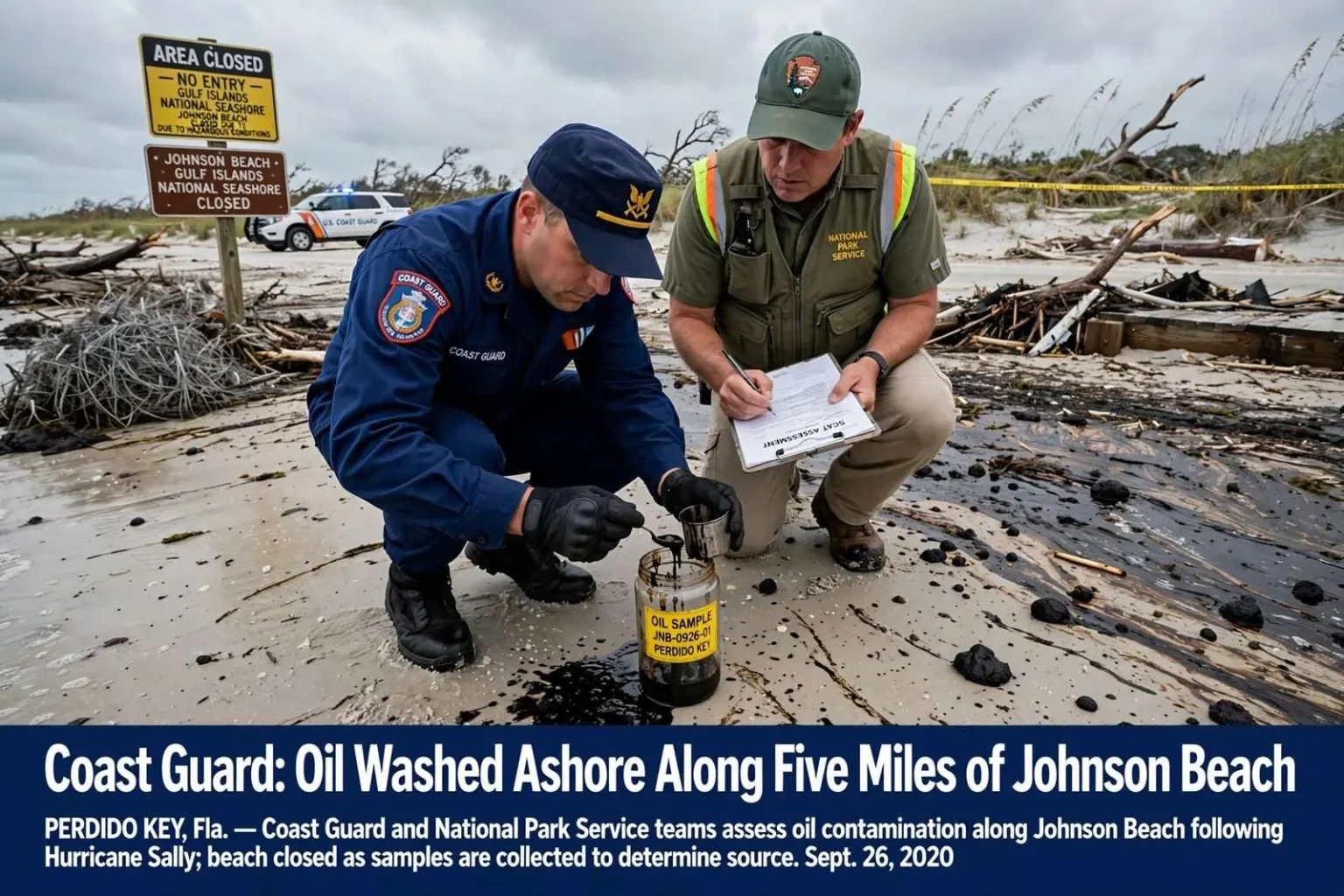
PERDIDO KEY, Fla. — The U.S. Coast Guard reported oil washed ashore along roughly five miles of Johnson Beach, part of Gulf Islands National Seashore, while Hurricane Sally cleanup continued. The origin of the oil was not immediately clear, and the beach remained closed to visitors.
Coast Guard spokesman Petty Officer 1st Class Dustin Williams said crews were on scene and had taken samples to help determine where the oil came from, and that the agency was working with the National Park Service on cleanup. Sampling is the standard first step in any mystery oil landing, because the composition of the material can point investigators toward a source, whether a vessel, a pipeline, a coastal facility, or oil stirred up from an old spill buried in the seafloor or shoreline.
The Park Service said the Coast Guard notified it of the slick along Perdido Key on Saturday, Sept. 26, and that the Coast Guard deployed a Shoreline Cleanup Assessment Technique team to evaluate the roughly five-mile slick. SCAT teams, as they are known, walk and document affected shoreline segment by segment, recording the type, volume, and distribution of oiling so responders can choose cleanup methods that remove the product without stripping away the beach itself.
NPS said the Perdido Key area of the national seashore would stay closed to all visitor access for safety and to speed recovery efforts while the assessment is underway. The closure added Johnson Beach to the list of Gulf Coast recreational areas shut down in Sally’s aftermath, when debris, damaged infrastructure, and hazardous conditions kept parks and beaches off limits well after the storm itself had passed.
For the barrier island communities at the Alabama-Florida line, the discovery was an unwelcome complication on top of an already daunting recovery. Sally had battered Perdido Key with days of onshore wind and surge, reshaping the beach profile and littering the shoreline with debris, and responders were still working through that damage when the reports of oil arrived from the same stretch of coast.
Where Mystery Oil Comes From After a Hurricane
When oil appears on Gulf beaches after a major storm with no obvious culprit, investigators generally work through a familiar list of possibilities. Hurricanes can rupture or dislodge pipes, damage vessels and sunken wrecks, overwhelm storage tanks and coastal facilities, and churn up tar and oil from historical spills that settled into the seabed decades ago and have been seeping back into the environment ever since. Storm surge can also push oiled material from one stretch of shoreline onto another, making the landing site a poor guide to the source.
The northern Gulf Coast carries a long history with petroleum, from offshore production to the tankers and barges that move through the region’s ports, and that history is one reason responders treat post-storm oil landings seriously even when the amounts look modest. The region also lived through the Deepwater Horizon disaster, which taught responders and coastal residents alike how oil behaves on barrier island beaches, how long it can linger in the sand, and how careful cleanup has to be to avoid doing more damage than the oil itself.
Sally’s path made such discoveries plausible across a wide area. The storm’s slow approach meant sustained winds and repeated surge cycles along the northern Gulf coastline, conditions strong enough to move substantial sand, destroy docks and vessels, and disturb anything settled in shallow nearshore waters. Responders across the affected zone were on the lookout for exactly the kind of pollution reports that surfaced at Johnson Beach.
Samples collected from the Perdido Key oiling would be analyzed to characterize the product, and the results guide both the investigation and the cleanup plan. Lighter products may evaporate and disperse with time and wave action, while heavier tar-like material persists and typically requires manual removal, which is more labor-intensive and raises the question of how much sand can responsibly be disturbed on a protected national seashore beach.
Johnson Beach and the Gulf Islands National Seashore
Johnson Beach sits at the western end of Perdido Key and is one of the signature recreation areas within Gulf Islands National Seashore, the National Park Service unit that strings together barrier islands along the Florida and Mississippi coasts. The beach is prized for its undeveloped dunes, its sea turtle nesting habitat, and the quiet stretch of Gulf shoreline it preserves just west of the condos and beach houses that line the rest of the key.
Because it is federal parkland, the beach is managed under conservation mandates that shape how any cleanup proceeds. Responders cannot simply grade or wash a national seashore beach the way a resort might treat its strand; dune vegetation, nesting shorebirds and sea turtles, and the underlying beach dynamics all constrain the tool kit. That is why the SCAT assessment matters so much in a park setting: the data determines which segments need aggressive cleanup and which can be left to natural processes that would remove light oiling without heavy equipment.
The full visitor closure of the Perdido Key area reflected both the hazard the oil posed and the practical demands of the work. Cleanup crews, assessment teams, and equipment need room to operate, and mixing the public into an active response site on a narrow barrier island risks injuries and delays. Park managers have repeatedly used full closures after storms for the same dual reason, and the Perdido Key unit had already been dealing with storm damage before the oil was reported.
The timing, days after Sally’s landfall in the region, meant the closure came while Gulf Coast residents were largely cut off from the beach anyway. Roads into the area were still being cleared, power was still out in parts of the coastal corridor, and the recreational season was effectively interrupted across the entire stretch of coast from Mobile Bay eastward through the Panhandle.
How an Oil Spill Response Unfolds
The response structure that takes over in a case like this follows a federal framework refined over decades of spills. The Coast Guard serves as the federal on-scene coordinator for coastal pollution incidents, working with the National Park Service when park resources are affected and with state environmental agencies in Florida. Identifying a responsible party matters for cost recovery, but the initial priority is always characterizing the oiling and stopping any ongoing release.
Shoreline Cleanup Assessment Technique teams are the eyes of that process. Composed of trained specialists from the Coast Guard, other agencies, and sometimes contracted scientists, they survey the coast in segments and classify the degree of oiling, from trace stains to heavy pooling. Their recommendations feed a shoreline cleanup plan that specifies tactics segment by segment: manual removal with rakes and bags in sensitive habitat, mechanical equipment on open sand where it can operate safely, and monitoring zones where natural recovery is judged the better option.
On a barrier island like Perdido Key, access is itself a logistical constraint. Heavy equipment has to come over a single road corridor, staging areas are scarce, and every vehicle that drives the beach or the dunes leaves its own mark. That is why assessments in national park units tend to be conservative, and why closures often last longer than the public expects: the park’s obligation is to the resource first.
Wildlife considerations add urgency. Oil on beaches and in nearshore waters can foul birds, sea turtles, and marine mammals, and responders watch for oiled animals throughout the operation. On Perdido Key, where sea turtles nest through the summer and into the fall, any cleanup work has to be coordinated with what remains of the nesting season, adding another layer to decisions about when and how crews move through the dunes.
Sally’s Lingering Footprint on the Coast
The oil report arrived as part of a longer list of environmental problems Sally left behind across the northern Gulf Coast. The storm’s slow passage had driven surge into communities around Mobile Bay and along the Panhandle, scoured portions of barrier islands, sunk and damaged boats, and spread debris across hundreds of miles of shoreline. State and federal agencies had been logging pollution reports of all kinds in the storm’s wake, from sheens around damaged vessels to displaced drums and tanks, and the Johnson Beach slick entered that running tally as one of the more visible items.
Barrier islands are the coast’s first line of defense and its most fragile geography at the same time. Perdido Key’s dunes took the brunt of Sally’s surge, overwashed in places and reshaped in others, and the same wave energy that moves sand also moves whatever contamination the storm disturbs. Residents and park visitors familiar with the key’s post-storm history know that changes to the island’s shape can persist for years, altering where sand accumulates, where turtles nest, and how the island absorbs the next storm.
For the National Park Service, the sequence of a major hurricane followed by a pollution response is a compound burden. Staff were already assessing damage to facilities, roads, and dune systems when the Coast Guard’s Saturday notification added an oil assessment to their workload. The agency’s decision to hold the Perdido Key area closed for the duration of the work was consistent with how it has managed the seashore after previous disasters, including the long closures that followed earlier Gulf oil disasters and hurricanes.
What Residents and Visitors Should Know
Officials’ guidance to the public during an oil landing is straightforward: stay off oiled beach, keep pets away from tarred material, and report any additional oiled areas or oiled wildlife to responders rather than attempting to clean or handle it themselves. Contact with petroleum products can irritate skin, and disturbing oiled sand can push contamination deeper into the beach or into the dune system where it is far harder to remove.
For the communities at the western end of the Panhandle and the eastern shore of Mobile County, the closure of Johnson Beach removed one of the area’s most accessible natural beaches at the height of the recovery period, when residents had few outlets. The park’s economic footprint in the region is real as well: the seashore draws visitors to the Perdido Key area in ordinary times, supporting the shops, rentals, and restaurants that were themselves digging out from the storm.
The investigation into the oil’s origin was continuing as responders worked the shoreline, and results of the sampling were expected to determine the direction of the case. If the material matched a known source, responders would pursue the responsible party for cleanup costs under federal oil pollution law; if the analysis pointed to old or unknown sources, the response would proceed as an orphan spill funded by the federal oil spill trust mechanisms that exist precisely for incidents with no identified owner.
Either way, the five-mile extent reported along Johnson Beach made this one of the more significant post-Sally pollution findings along the northern Gulf shoreline. The Coast Guard and the Park Service committed to coordinating through the assessment and cleanup, and the Perdido Key area of Gulf Islands National Seashore was to remain closed to all visitor access while that work continued, with the park’s standing guidance that reopening would follow when the beach was safe and the response effort no longer needed the ground to itself.
Updates on the assessment, the sampling results, and the status of the closure were expected through the Coast Guard and National Park Service as the response moved from evaluation into active cleanup along the affected stretch of Johnson Beach.