Gulf Coast Warms Into the 70s With Little Rain This Week, but High Rip Current Risk and Rough Seas Threaten Beaches
After a cool, cloudy Monday, sunshine returns and highs climb into the mid- to upper 70s with almost no rain for seven days, while a high rip current risk Tuesday through Thursday and a Small Craft Advisory with 5- to 8-foot seas make the Gulf dangerous.
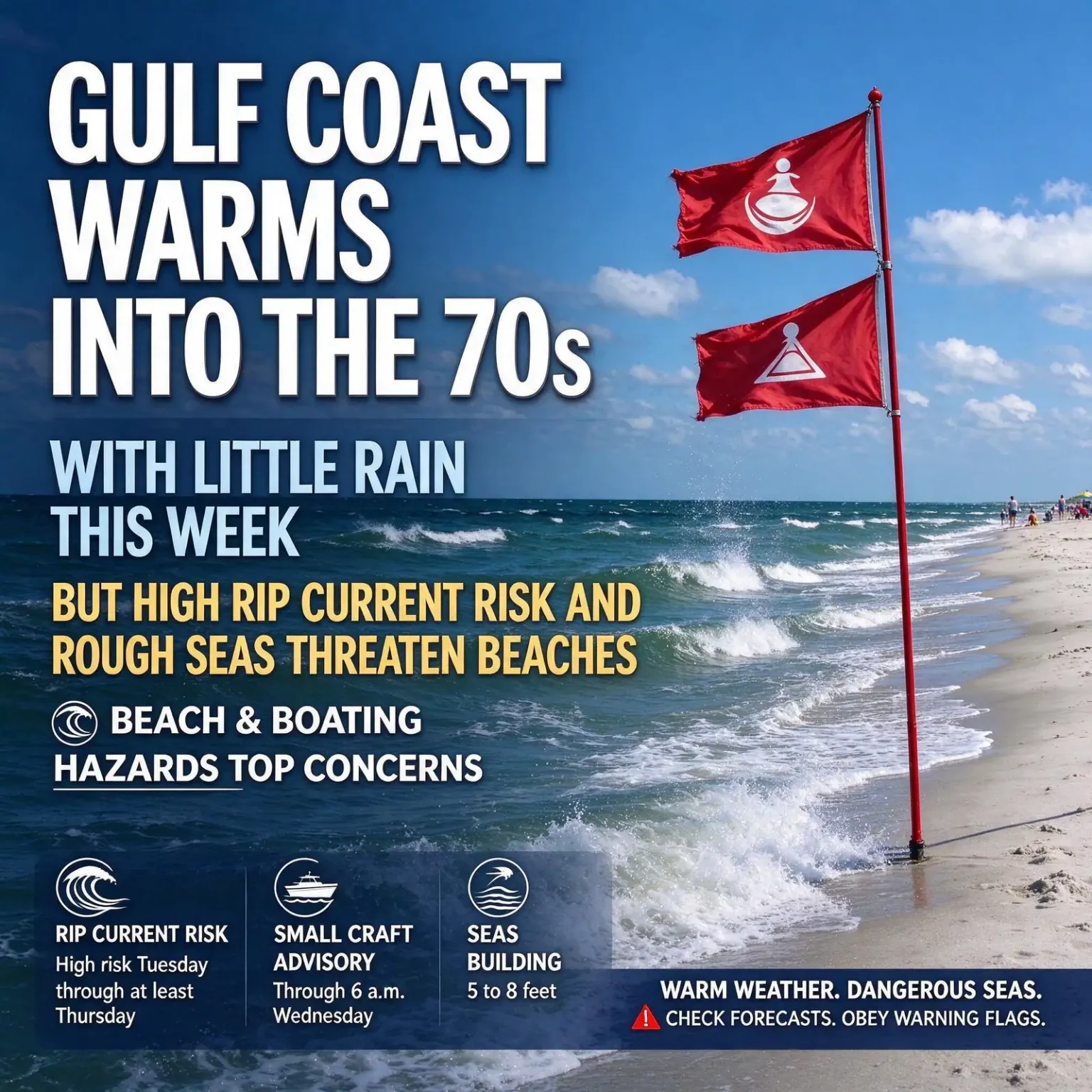
MOBILE, Ala. — Highs climbing into the mid- to upper 70s and almost no rain are in store for the Gulf Coast this week, but the calm weather on land masks a serious danger at the beach. A high risk of life-threatening rip currents is expected from Tuesday through at least Thursday, and a Small Craft Advisory covers Gulf waters into Wednesday as strong east-northeast winds churn up the seas.
Monday is the exception to the warming trend, with gray skies, a chilly breeze and temperatures held in the 50s and 60s before sunshine returns on Tuesday.
The Week at a Glance
| Day | Sky and Rain | Afternoon Highs | Morning Lows |
|---|---|---|---|
| Monday | Mostly cloudy; a few sprinkles possible near the coast | 50s to 60s | Mid-30s far inland, 40s farther south, low 50s at the immediate coast |
| Tuesday | Sunny | Near 70 | 30s inland, 40s and 50s south and along the coast |
| Wednesday | Mostly sunny | Mid-70s | Milder; 40s inland, 50s farther south |
| Thursday | Mostly sunny | Mid- to upper 70s | 40s inland, 50s south, near 60 at some beachfront spots |
| Friday into the weekend | A bit more cloud cover, mostly dry; a stray shower possible late in the weekend | Mid- to upper 70s | Mild |
Beach and Boating Hazards Top the Concerns
The most significant weather threat this week will be along the shoreline and offshore rather than inland. Increasing east to northeast winds over the Gulf will build waves and strengthen the currents that pull swimmers away from shore.
- Rip currents: The risk climbs on Monday, and a high risk of life-threatening rip currents is expected Tuesday through at least Thursday.
- Surf: Rough, hazardous surf is possible Tuesday into Wednesday, especially along Alabama’s beaches.
- Small Craft Advisory: In effect for nearshore and offshore Gulf waters from 6 a.m. Monday until 6 a.m. Wednesday.
- Seas: Building to 5 to 8 feet, with hazardous conditions for small boats possibly lasting beyond the end of the advisory.
Beachgoers should pay close attention to the flag system and avoid entering the water when conditions are dangerous. The warm afternoons may tempt visitors to wade in, but a high rip current risk means the surf zone can be deadly even for strong swimmers.
Understanding the beach flags
Gulf Shores, Orange Beach and other coastal communities use a color-coded warning flag system:
- Green: Low hazard, calm conditions; still exercise caution.
- Yellow: Medium hazard, moderate surf and currents.
- Red: High hazard, with high surf and strong currents.
- Double red: Water closed to the public.
- Purple: Dangerous marine life present.
If you are caught in a rip current
National water safety guidance offers several key steps:
- Stay calm and do not fight the current by swimming straight back to shore.
- Swim parallel to the shoreline until you are out of the current, then angle back toward the beach.
- If you cannot escape, float or tread water and wave or call for help.
- If you see someone in trouble, alert a lifeguard or call 911 rather than entering the water yourself, and throw them something that floats if possible.
Advice for boaters
A Small Craft Advisory signals winds and seas that can be hazardous for smaller vessels. Recreational boaters planning to head into the Gulf early this week should consider postponing their trips, and anyone who must go out should check the latest marine forecast, file a float plan, make sure life jackets are aboard for everyone and keep a working marine radio on hand. With seas of 5 to 8 feet expected, conditions may be too rough even for moderately sized boats.
Monday: A Cool, Cloudy Holdout
Cloud cover overnight is keeping temperatures from dropping as sharply as they did on recent nights, though inland areas will still start the day chilly. Early Monday lows range from the mid-30s in the far northern part of the region to the 40s farther south, with some spots right along the coast holding in the low 50s. Patchy frost is possible in the northernmost inland counties.
Skies are expected to stay mostly cloudy through Monday, with highs only reaching the 50s and 60s. A steady breeze out of the northeast will make it feel cooler, particularly near the water.
A weak upper-level disturbance moving across the area could squeeze out a few sprinkles, mainly close to the coast. Because the air near the ground is quite dry, much of that moisture is likely to evaporate before it reaches the surface, a phenomenon known as virga. Most communities will stay dry, and any rainfall will be too light to matter.
Tuesday Through Thursday: Sunshine and a Steady Warm-Up
Skies should clear Monday night, allowing temperatures to fall into the 30s again inland by early Tuesday, with 40s and 50s closer to the coast. Once the sun comes out, though, the warming trend will take hold.
High pressure will build over the region, bringing mostly sunny skies and afternoon highs near 70 on Tuesday, in the middle 70s on Wednesday and in the middle to upper 70s on Thursday. Overnight lows will moderate as the week goes on, generally settling in the 40s inland and the 50s farther south, with some beachfront communities staying close to 60 by late week.
Dry Pattern Continues Into the Weekend
Clouds may increase a bit toward the end of the workweek, but there is little sign of meaningful rain. Highs will stay in the middle to upper 70s into the weekend, which should be good news for outdoor events, high school playoff games and holiday shopping trips. A stray shower cannot be completely ruled out late in the weekend, but the vast majority of locations should remain dry over the next seven days.
Dry weather and outdoor burning
An extended dry stretch, combined with low humidity and breezy conditions, can raise the risk that outdoor fires will spread. Residents planning to burn yard debris should check local and state burn restrictions, avoid burning on windy days, keep a water source nearby and never leave a fire unattended.
Thanksgiving Outlook
Looking further ahead, the quiet pattern could continue until around Thanksgiving, which falls on Thursday, Nov. 26. Longer-range computer guidance suggests a more significant weather system could arrive after the holiday, but it is far too early to determine its timing or how it might affect the central Gulf Coast. Travelers and anyone planning outdoor holiday gatherings should keep an eye on updated forecasts as the date approaches.
Quick Takeaways
- Monday stays cool and cloudy, with highs in the 50s and 60s.
- Sunshine returns Tuesday, with highs warming into the mid- to upper 70s by Thursday.
- Little to no meaningful rain is expected for the next seven days.
- A high risk of rip currents is expected Tuesday through at least Thursday; stay out of the water when red flags fly.
- A Small Craft Advisory runs from 6 a.m. Monday to 6 a.m. Wednesday, with seas of 5 to 8 feet.
- The dry pattern may last until around Thanksgiving, with a possible system after the holiday.