A Hot, Quiet Midweek Gives Way to Storms Thursday Through the Weekend Across South Alabama
Rain chances climb to around 60 percent Thursday and stay elevated through the weekend across South Alabama, with locally heavy rain, frequent lightning and gusty winds possible. The tropics remain quiet during peak hurricane season.
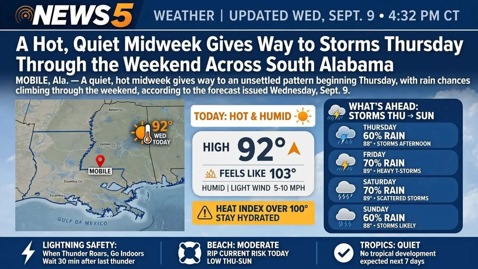
MOBILE, Ala. — A quiet, hot midweek across South Alabama gives way to an unsettled pattern beginning Thursday, with rain chances climbing through the weekend, according to the forecast issued Wednesday, Sept. 9.
Highs Wednesday surged into the lower 90s with heat index values above 100 degrees. Soggy conditions are in the forecast Thursday through Sunday as storm chances increase significantly across the region.
Scattered Storms Thursday
Rain chances jump to around 60 percent Thursday, meaning showers and thunderstorms will be more common than dry weather — particularly during the afternoon.
Anyone with outdoor plans Thursday should have a backup.
The forecast does not call for continuous rain. There will be dry windows between storms. The practical guidance is to stay flexible and check the forecast through the day rather than committing to a plan made in the morning.
A Wet Weekend
Scattered to numerous showers and thunderstorms are expected to develop Friday and Saturday, with the heaviest activity likely during afternoon and evening hours.
Some storms could produce locally heavy rainfall, frequent lightning and gusty winds — conditions that affect outdoor events, sports and recreation.
Temperatures will ease back into the upper 80s to around 90 degrees, cooler than midweek. Humidity will stay high, keeping conditions muggy between storms.
What Afternoon Storms Do on the Gulf Coast
The pattern described here is characteristic of September along the northern Gulf, and understanding the mechanism helps with planning around it.
Daytime heating over land drives convection. As the surface warms through the day, warm moist air rises, and when there is sufficient moisture and instability, that rising air produces thunderstorms. This is why the forecast concentrates activity in the afternoon and evening rather than spreading it evenly.
Sea breeze circulation adds to it. Land heats faster than water, producing an onshore breeze that pushes inland during the day. The leading edge of that breeze acts as a lifting mechanism, frequently triggering storms along a line that moves inland through the afternoon.
The practical implication for coastal residents is that mornings are the reliable window. Outdoor work, exercise and recreation scheduled before midday are far more likely to stay dry than the same activity scheduled for 3 p.m.
Lightning Is the Real Hazard
The forecast mentions frequent lightning, and it warrants more attention than it typically receives.
Lightning kills more people in the United States in a typical year than tornadoes or hurricanes. It also kills people who did not think they were in a storm, because lightning can strike well ahead of visible rain.
The guidance from the National Weather Service is simple and worth repeating: when thunder roars, go indoors. If thunder can be heard, lightning is close enough to strike. A substantial building or a hard-topped vehicle provides protection. A dugout, a picnic shelter, a tent or a tree does not.
The recommended wait is 30 minutes after the last thunder before resuming outdoor activity.
That guidance matters particularly for the youth sports and outdoor events the forecast specifically flags. September weekends on the Gulf Coast are full of both.
Beach Forecast
There is a moderate risk of rip currents Wednesday, with low risk through the remainder of the week.
For those planning water activities on the Gulf, Thursday through Saturday brings an increased threat of thunderstorms. Conditions can change quickly; check the marine forecast before heading out.
A word on rip currents, since the risk level changes daily and the flag system depends on people understanding what it means. A rip current is a narrow channel of water moving away from shore, and it does not pull a swimmer under — it pulls them out. The danger comes from exhaustion, as swimmers attempt to swim directly back toward the beach against a current faster than they can swim.
The standard guidance is to swim parallel to shore to exit the current, then angle back toward the beach. A swimmer unable to escape should float, tread water and signal for help rather than fighting it.
Alabama beaches use a colored flag system to communicate conditions, and the flags reflect current assessments rather than general guidance. Check them.
The Tropics Are Quiet
On this peak week of hurricane season, the tropics are quiet, with no tropical development expected over the next seven days.
That is genuinely notable. Mid-September falls at the statistical peak of the Atlantic hurricane season, the point at which conditions across the basin are historically most favorable for tropical development. Sea surface temperatures are near their annual maximum, and other atmospheric conditions typically align.
A quiet peak week is welcome. It is not, however, a reason to stand down. The season runs through Nov. 30, and the Gulf Coast has experienced significant late-season storms. A seven-day outlook is a seven-day outlook.
The quiet stretch is a reasonable time to check preparations: reviewing an evacuation plan, confirming insurance coverage, and restocking supplies. Those tasks are considerably easier now than they are with a storm in the Gulf.
Staying Informed
Keep phones charged for weather updates. Anyone caught outside when a storm develops should seek shelter immediately.
Reliable sources include the National Weather Service offices serving the region, NOAA Weather Radio, and local emergency management notification systems, which most Gulf Coast counties and municipalities operate.