Dauphin Island Braces for Hurricane Ida, Urges West-End Evacuation Before Sundown
Dauphin Island Mayor Jeff Collier urged west-end evacuation before sundown as Hurricane Ida approached with storm surge in August 2021.
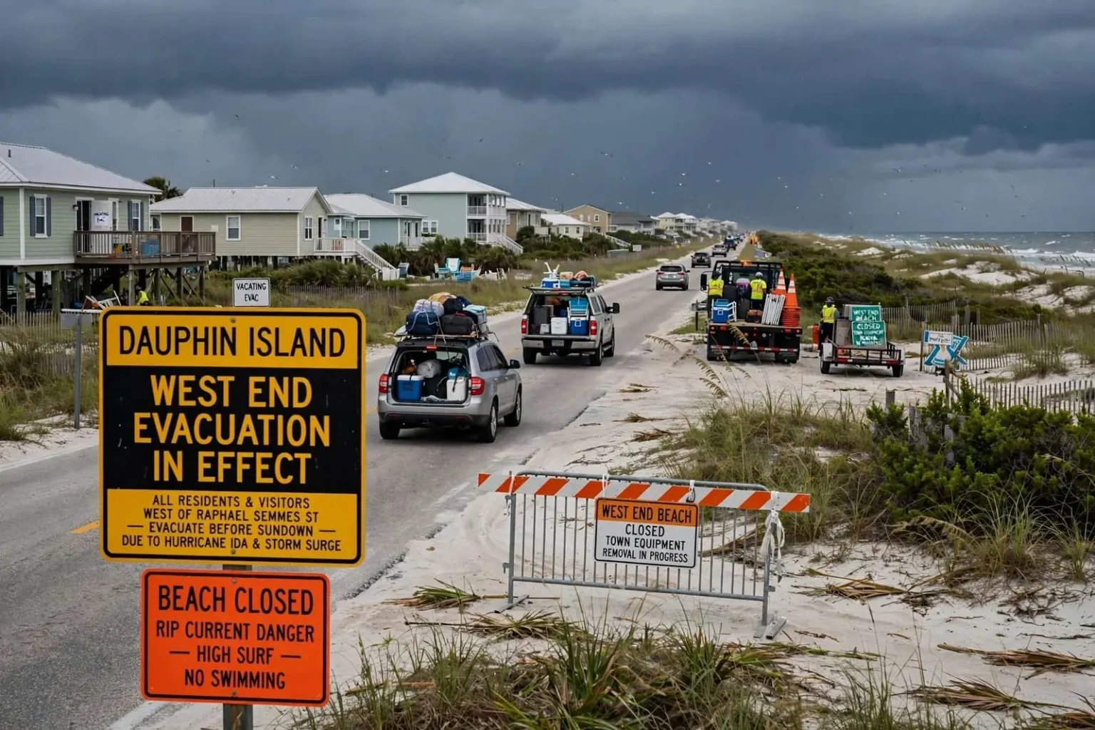
Dauphin Island braced for potential impacts from Hurricane Ida on Friday, with Mayor Jeff Collier urging everyone west of Raphael Semmes Street to evacuate before sundown because of the hurricane and expected storm surge. The voluntary order covered the island’s low-lying western arm, the section most vulnerable to Gulf water in any storm, and it gave residents and visitors a hard deadline — out before dark — that reflected how quickly conditions can deteriorate on a barrier island once the wind field from a large hurricane begins to arrive.
Ida was churning in the Gulf of Mexico on a path that threatened the north-central Gulf Coast, and while the storm’s center was forecast to come ashore west of Alabama, its size meant the entire northern Gulf shoreline faced surge, seas and deteriorating weather. Dauphin Island, sitting at the mouth of Mobile Bay directly exposed to the open Gulf, takes water from systems far to its west, and Ida’s approach put the town squarely inside the warning zone for coastal flooding. The evacuation request west of Raphael Semmes Street drew the line exactly where island officials customarily draw it: at the boundary of the west end’s most flood-prone streets.
Visitors were among those packing up and heading home. Sarah Hennebert, visiting from Tennessee, said she was supposed to be out by 5 p.m. Emily Hein, visiting from Missouri, said she was grateful her rental host thought to warn her — otherwise she might have stayed through the next day. The scene along the island’s western streets on Friday was a familiar one for late-summer weekends: cars loaded with beach gear, rentals being emptied a night early, and vacationers rearranging plans on the advice of hosts and town officials.
Why the West End Goes First
Collier emphasized that the west end is flood-prone and that many renters and tourists there are not accustomed to hurricane conditions. “Be proactive,” he said, noting that is where a large share of the island’s visitors are concentrated. The message bundled two concerns into one warning: the geography of the west end, which sits low and narrow and floods when the Gulf rises, and the population there, which swells with renters and tourists in summer and includes many visitors experiencing their first tropical threat.
The west end’s buildings are mostly elevated camps and rental homes, reached by a single road that floods early and drains late. When surge arrives, that road can become impassable before conditions look serious elsewhere on the island, trapping anyone who waits too long on the wrong side of the water. Evacuating before sundown ensures that residents and visitors leave in daylight, over still-dry roads, with time to spare — a margin that matters when the Gulf is rising faster than the forecast suggested.
Raphael Semmes Street marks the practical divide between the higher, older eastern portion of the island and the vulnerable western arm. West of that line, dune elevations drop, lots sit closer to sea level, and the island narrows toward the shoals at its western tip. Island officials have used the same dividing line in evacuation guidance through repeated Gulf storms, because storm history there is unambiguous: water crosses the west-end road in nearly every significant Gulf event, and the depth and duration scale with the storm’s size and track.
Rip Currents and Beach Closures
Rip current warnings were already flashing along Dauphin Island, and crews spent Friday afternoon moving equipment off the vulnerable West End Beach, which officials had already closed ahead of the storm. The beach closure came before the evacuation deadline, reflecting the sequence island officials follow as a storm approaches: secure the beach first, then clear the low-lying neighborhoods. Moving town equipment off the west end — vehicles, barricades, beach apparatus — protects the town’s assets from salt water and clears the way for the surge to pass through without striking public property.
The rip current risk that precedes a Gulf hurricane is a hazard in its own right. Long-period swells from a distant storm arrive days before the weather does, and they generate strong currents pulling away from the beaches that can catch swimmers on days that still look inviting. Officials pair those warnings with beach closures because the west end beach has no lifeguards and few crowds to summon help when a swimmer is pulled offshore. Visitors staying through the weekend were urged to stay out of the water entirely while the storm’s swells reached the coast.
For the island’s full-time residents west of Raphael Semmes Street, the evacuation request repeated a routine most have practiced before. The town’s guidance — leave before sundown, take what matters, and wait for official word that the road is safe — exists because the alternative has proven costly in past storms, when residents who stayed on the west end had to be rescued after floodwater cut the road.
The Friday afternoon rhythm of the island told the story of a community that knows the drill. Sand vehicles and town crews worked the west end while the beach remained closed, the causeway traffic thickened with cars heading north, and the streets west of the evacuation line grew steadily quieter as the deadline approached. Officials planned to hold the closure through the storm’s passage and reopen the west end only after crews could verify the road.
The Storm at Sea
Hurricane Ida entered the Gulf of Mexico after crossing western Cuba and began strengthening over the warm waters of the central Gulf, with forecasters projecting landfall along the Louisiana coast. For communities on the Alabama coast, the forecast geography mattered as much as the storm’s strength: a system coming ashore to the west pushes its worst surge east of the center only if the storm is enormous, but it reliably sends elevated water, dangerous seas and bands of heavy weather toward the Alabama coastline in the days before landfall. Dauphin Island’s evacuation decision reflected that reality — the island floods on Ida-type tracks even when the storm’s core stays hundreds of miles away.
Forecasters warned that Ida was likely to be a major hurricane at landfall, which raised the stakes for every community on the northern Gulf shore. The island’s exposure to a large storm’s peripheral effects is not theoretical: past hurricanes that struck Louisiana have flooded Dauphin Island streets, pushed water into homes on the west end, and cut the road in both directions. The town’s decision to request an early evacuation west of Raphael Semmes Street fit that history.
Rental Hosts and Visitor Safety
The experience of visitors like Hein — alerted by a rental host rather than by her own weather monitoring — illustrates a recurring challenge for Gulf Coast resort communities. Vacationers arrive for a beach weekend with limited awareness of tropical threats, and many do not follow local news or official social media while on vacation. Rental owners and property managers have become a de facto warning network, passing along evacuation requests and beach conditions to guests who might otherwise ride out a storm unaware of the risk.
On Dauphin Island, where rental homes dominate the west end, that network matters. The mayor’s “be proactive” message was aimed partly at hosts: warn your guests early, help them pack, and make sure the west end empties before the water rises. The visitors encountered on the island Friday — Hennebert loading up ahead of her 5 p.m. deadline, Hein grateful for the warning — were following through on that chain of communication, and town officials counted on hundreds more doing the same before sundown.
Summer weekends put the island’s visitor population at its annual peak in late August, and a Friday evacuation request therefore touches more people on Dauphin Island than the same request would in October. The town’s ability to reach those visitors through hosts, signage and media coverage determines how completely the west end empties, and Friday’s scenes of packed cars heading north across the bridge suggested the message was getting through.
What Happens After the Storm
Evacuation is only the first phase of the island’s storm routine. Once Ida passed, officials would assess the west end road for washouts and debris, check utilities, and determine when residents could return — a sequence that can take anywhere from hours to weeks depending on what the surge does to the western arm. The town’s public works crews and police concentrate on that assessment as soon as conditions allow, because reentry decisions affect hundreds of property owners waiting on the mainland.
For Friday night, though, the town’s focus was on the deadline. Collier’s request — everyone west of Raphael Semmes Street gone before sundown — was the last practical window the island would have before Ida’s effects reached the coast, and the crews moving equipment off West End Beach, the rip current warnings flashing at the beaches, and the visitors loading their cars were all parts of the same effort to put the island in the safest possible position before the Gulf rose.