Dauphin Island Closes West End as Water Floods Roadway Ahead of Tropical Storm Barry
Water flooded Dauphin Island's west end roadway ahead of Tropical Storm Barry, prompting officials to close the area for safety reasons.
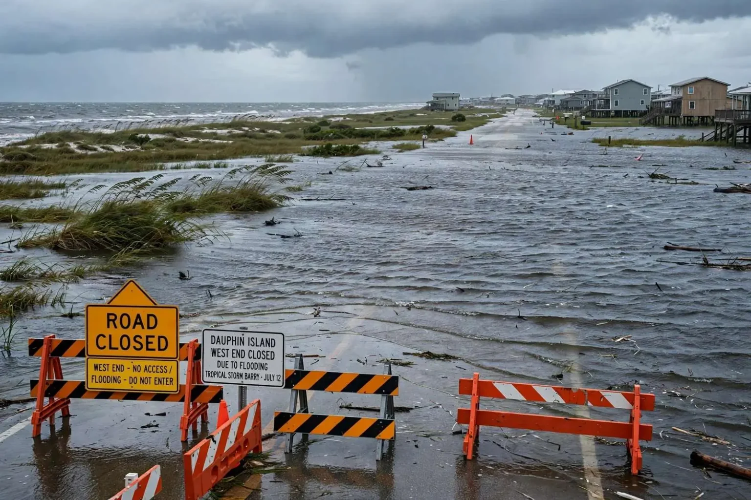
Dauphin Island officials shut down the west end of the barrier island Friday as water pushed ahead of Tropical Storm Barry began spilling onto the roadway. The closure came as the storm, still churning in the Gulf of Mexico, sent waves of Gulf water toward the Alabama coast on southerly winds, and it left one of the island’s most popular stretches cut off from traffic until conditions improve. Town leaders closed the area for safety reasons, cutting off access until conditions improve and water recedes from the low-lying road surface.
Flooding was already visible along the road serving the island’s west end on July 12, well before the storm’s arrival, as southerly winds off the Gulf piled water into low-lying stretches of the coast. That kind of pre-storm flooding is a well-known phenomenon on the island, where the road across the west end sits just above normal tide levels and rises only modestly even in dry weather. With the Gulf running higher ahead of a named system, water that stays within its banks on ordinary days spills across the pavement, forcing officials to decide between leaving the route open to drivers who may not understand the hazard or closing it outright.
Town leaders chose closure, cutting off vehicle access until conditions improve. The affected area serves the island’s west end, the sparsely developed western reach of the barrier island that extends toward the Little Dauphin Island and Sand Island shoals. Access matters for the property owners who keep homes there, but officials weighed that against the danger of vehicles stranded in floodwater, and the closure order reflected the judgment that safety took priority while the storm approached.
A Familiar Pattern on a Narrow Island
West-end flooding is a familiar pattern on the narrow barrier island whenever sustained onshore winds accompany a Gulf storm system. Dauphin Island sits at the mouth of Mobile Bay, exposed directly to the open Gulf on its south side, and its western arm is low, narrow and fronted by shallow water on both sides. When winds blow persistently from the south, they push Gulf water through the passes and across the flats, and the water has nowhere to go but over the road. Residents have watched the same sequence play out through decades of tropical systems, from minor setups that flood a few hundred feet of pavement to major hurricanes that rearrange the landscape entirely.
The west end’s vulnerability is a product of its geography. Unlike the eastern end of the island, which sits higher and shelters behind Fort Gaines and the eastern tip, the western arm is a thin ribbon of sand dotted with camps and houses on stilts. Storm surge from the Gulf sweeps across it, and even without a direct hit, days of onshore flow can submerge the roadway. Tropical Storm Barry was churning in the Gulf of Mexico at the time and drawing attention across coastal Alabama, where communities from Dauphin Island to Bayou La Batre kept a close watch on tides and rising water.
Bayou La Batre, the working waterfront community across the bay to the east, faces a parallel set of concerns in any Gulf event. Its shrimp fleet and low-lying streets sit on the western shore of Portersville Bay, and sustained southerly winds pile water into the bayou just as they do onto Dauphin Island’s west end. The two communities share the same essential calculus when a storm enters the Gulf: watch the tides, watch the wind direction, and assume that water will find the lowest ground well before the storm center ever arrives.
What the Closure Means for Residents and Visitors
Residents and visitors were urged to stay out of the closed area and avoid driving through standing water while the storm passes. The warning covers more than convenience: floodwater on a barrier island road hides washed-out pavement, debris and displaced pavement edges, and vehicles that push through standing water risk stalling in salt water or being swept by currents that look shallow but run strong. Emergency responders also face added risk when calls come from flooded areas, which is a further reason officials seal a roadway before conditions deteriorate rather than after.
The closure’s timing — Friday, before Barry’s center ever approached the coast — reflected the way barrier-island officials have learned to operate. Water arrives with the wind, not with the storm, and by the time a storm’s rain bands reach the coast the west end road may already be impassable. Closing early keeps residents from being caught on the wrong side of a flooded stretch, keeps sightseers away from a hazard, and gives the town a clear perimeter to manage while the Gulf runs high.
For the island’s west-end property owners, closures of this kind are a routine cost of barrier-island life. Access resumes when the water recedes and crews confirm the road surface is intact, a process that can take hours in a minor event and days or longer after a serious one. The town’s decision to close the area for safety reasons pending improved conditions follows the pattern residents know well, and it signaled that officials were treating Barry’s approach — whatever track the storm ultimately took — as a real test of the island’s defenses.
Barrier Island Geography and Storm Behavior
Dauphin Island’s situation at the mouth of Mobile Bay makes it the Gulf’s first stop for storm effects moving toward the Alabama coast. The island runs roughly east to west for about fourteen miles, but only the eastern portion is developed on high ground; the west end extends as a narrow spit where dune elevations are measured in a few feet. That geometry explains why the same storm can leave the east end mostly dry while water crosses the west-end road repeatedly through a single tidal cycle.
Southerly winds do the damage even at tropical storm strength. A persistent blow from the south pushes surface water northward across the shallow Gulf shelf, and because the water along the Alabama coast is shallow for miles offshore, the wind’s effect is amplified — the sea literally piles up against the coast. Forecasters call the result wind-driven flooding or precursor surge, and on Dauphin Island it routinely shows up a day or more before a system’s center crosses the coastline, exactly as it did on July 12 while Barry was still organizing in the Gulf.
The west end road is the island’s only link to that stretch of the community, which is why flooding there draws an immediate administrative response. When the road goes under, residents on the far side lose straightforward vehicle access, and the town must weigh rescue logistics, utility access and debris removal against the danger of letting traffic through. Closing the road formalizes what the water has already imposed, and it puts the burden on the town to reopen as soon as the surface is verified safe.
The Regional Watch Along Coastal Alabama
Tropical Storm Barry drew attention across coastal Alabama as it churned in the Gulf of Mexico, with communities from Dauphin Island to Bayou La Batre keeping a close watch on tides and rising water. Coastal residents in south Mobile County track these systems differently from inland neighbors: the first question is rarely wind but water, because tide anomalies of one to three feet — enough to flood low roads and waterfront property — can arrive from a storm hundreds of miles away. Barry’s approach fit that pattern, with effects on the coast preceding any landfall.
Mobile Bay adds its own dynamics to a southerly wind event. The bay runs north to south, and sustained winds from the Gulf drive water up the bay toward Mobile, raising water levels along the causeway and the western shore communities of Coden and Bayou La Batre. The same wind that drowns the Dauphin Island west-end road lifts water into the bay and its tributaries, which is why the island’s flooding and the mainland’s flood concerns so often arrive together. Emergency managers across the region watch the same wind forecasts and tide gauges when a system like Barry enters the Gulf.
For Dauphin Island, the calculation is sharpened by the island’s single road connection to the mainland. The Gordon Persons Bridge and the causeway across the Mississippi Sound link the island to the Alabama mainland, and when west-end flooding closes the island’s western reach, the community’s evacuation and response capacity narrows to that one corridor. Town officials have learned to act early — closing low areas, moving equipment, and warning residents — because the window between “water on the road” and “island effects” can be short.
Advice That Applies Every Storm Season
The town’s guidance during the Barry approach repeated the standing advice that coastal Alabama residents hear every hurricane season: stay out of closed areas, never drive through standing water, and let conditions improve before returning to flood-prone stretches. The warnings exist because the failures are familiar — vehicles stalled in salt water, drivers swept into channels, and responders placed at risk for rescues that early patience would have prevented. On a barrier island, where the flooded road may be the only road, the advice carries particular weight.
As Barry passed, the west end’s closure remained in effect until conditions improved and officials could assess the roadway. The episode added one more entry to the long record of Gulf systems that flooded the island’s western arm without ever making a direct strike there, and it served as the seasonal reminder that on Dauphin Island, the Gulf begins testing a town’s defenses days before any storm arrives.