A Decade After Hurricane Ivan, Baldwin County Beaches Build Tougher
Ten years after Hurricane Ivan devastated Baldwin County's coast, tougher building codes and emergency plans have reshaped Gulf Shores and Orange Beach.
More than a decade after Hurricane Ivan tore into Baldwin County’s coastline as a Category 3 storm, local officials say the beach communities it battered would likely weather a repeat performance far better today. Ivan came ashore in September 2004 with wind gusts topping 120 mph and a storm surge as high as 14 feet. Beachfront homes and condominiums bore the brunt of it — many structures were destroyed outright, and two condo buildings in Orange Beach partially collapsed.
The storm was a hinge point for coastal construction in Alabama. In the years since, building codes along the coast have been rewritten from the ground up, and the difference is visible in every row of new construction between the Perdido Pass and Fort Morgan.
Codes Rewritten After the Storm
Before Ivan, structures at the water’s edge in Gulf Shores and Orange Beach only had to withstand 100 mph wind gusts. Buildings constructed today must hold up to 140 mph gusts, and Gulf Shores went further this year, adopting the 2015 International Building Code that requires new construction to withstand 160 mph gusts with sustained winds of 124 mph — benchmarks tied to a Category 3 hurricane. The progression tracks the storm itself: what Ivan actually delivered to the coast was well beyond what the old code anticipated, and the new numbers were written to match that experience.
“On the beachfront, most of the older wood-framed structures were taken out by Ivan, and what has been built back is like night and day,” said Lannie Smith, Orange Beach’s building official and emergency management coordinator. “I would venture to guess we would have half as much damage as we did with Ivan today, just because we’re building stronger, we’re building higher, and we’ve got a beach that’s protecting those houses a lot better.”
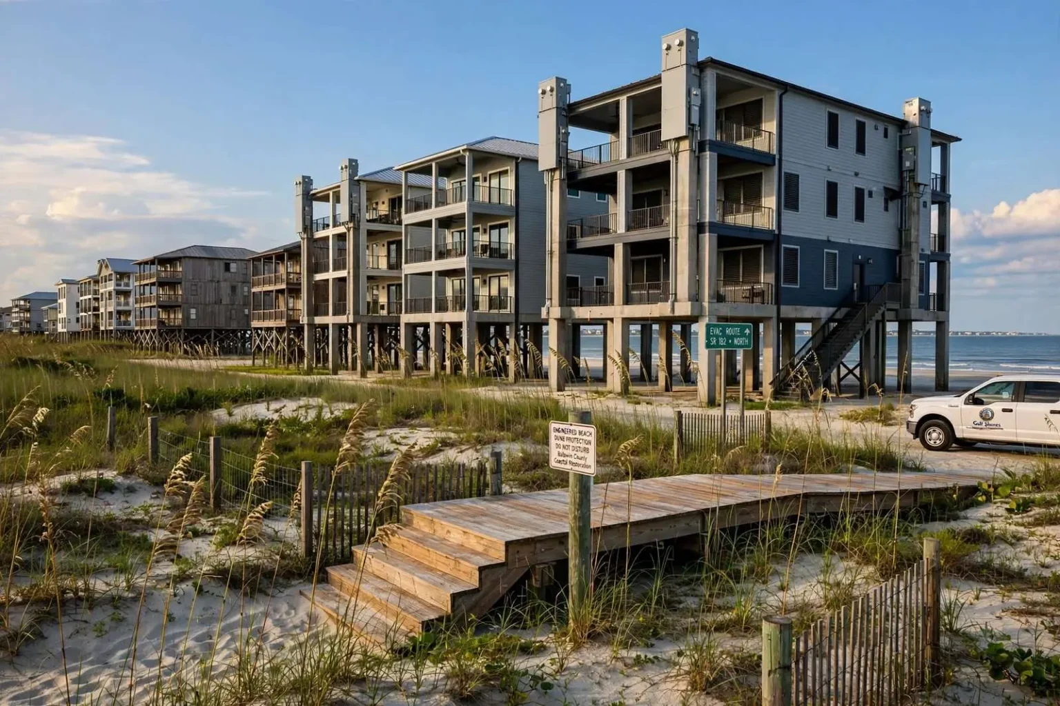
The rebuilding boom that followed the storm gave inspectors something rare: the chance to rebuild an entire beachfront under a modern code in the space of a few years. Properties that survived Ivan intact largely predated the stricter standards; nearly everything constructed after 2004 was subject to them. The result, more than a decade on, is a coastline in which the newest buildings — typically elevated on reinforced concrete piles, with impact-rated windows and engineered roof systems — sit beside the oldest stock that the storm somehow spared.
Building Higher, Building Stronger
Gulf Shores Mayor Robert Craft said the storm forced a rethink of construction from the ground up. New buildings sit on higher elevations with deeper foundations and reinforced concrete, he said, and critical infrastructure such as electrical boxes and sewer hookups has been moved off the ground floor entirely, aimed at getting residents and businesses back into their properties faster after future storms. The repositioning of utilities sounds like a small detail; after Ivan, it was the difference between a structure that could be reoccupied within weeks and one that waited months for systems to be rebuilt.
Elevation carries the same logic. Storm surge, not wind, destroys most beachfront property, and the flood maps adopted after the 2004 and 2005 hurricane seasons pushed minimum finished-floor elevations upward along the coast. A house raised several feet above its predecessor costs more to build and less to insure, and — as Craft noted — returns its owners to the tax rolls and the rental market dramatically sooner after a storm.
Orange Beach has required homes and condos to withstand 140 mph winds since 2004 and layers on additional requirements beyond the standard building code, including extra window protection, sealed roof decks and water-resistant barriers beneath shingles. “They’re not just allowed to build to code anymore — they have to build to what we call Code Plus,” Smith said, adding that reduced storm debris means faster road clearance and quicker recovery for everyone.
The debris point is more significant than it sounds. After Ivan, streets across the island city were choked with shattered lumber, roofing, insulation and household contents, and every ton of debris slowed emergency traffic and line-of-sight utility repair. A building that stays intact is not only a saved asset for its owner; it is one less obstruction for the crews reopening the single road — State Route 182, and Perdido Beach Boulevard before it — that ties the community together. Code Plus was written with that system-wide arithmetic in mind.
An Engineered Beach as a Buffer
Beach renourishment and dune construction have added another layer of protection, according to Orange Beach City Administrator Ken Grimes, who called the city’s maintained “engineered beach” a major storm buffer even as it also anchors the area’s tourism economy. The dune line rebuilt after Ivan absorbed surge and wave energy that would otherwise have reached the first row of structures, and the wide recreational beach that draws millions of visitors does double duty as the town’s first line of defense.
Renourishment is not a one-time project. Sand migrates along the coast with every storm and every season, and maintaining an engineered beach requires periodic re-nourishment, dredged from approved offshore borrow sites and pumped ashore. The expense is considerable, but Baldwin County’s leaders have repeatedly judged it cheaper than the alternative: every foot of beach in front of a seawall or a pilon foundation is a foot of storm energy dissipated before it reaches the built environment.
A New Way of Coordinating
The storm also reshaped how local governments coordinate. Following Ivan and Hurricane Katrina the next year, Gulf Shores and Orange Beach adopted National Incident Management System training, giving city employees clearly defined roles during storm response rather than improvising each morning during recovery, said Gulf Shores emergency management coordinator Brandan Franklin.
NIMS, adopted nationwide after the widely criticized responses to Katrina, standardizes terminology, command structure and interagency communication, so that police, public works, utilities and out-of-town responders arriving after a storm operate from a single playbook. For resort communities that double or triple in population during tourist season — and that absorb thousands of returning evacuees in the hours after a storm — the difference between improvised and structured response is measured in hours of recovery time.
Growth Makes Planning Harder
Population growth adds urgency to the planning. Census figures show Gulf Shores grew roughly 60 percent between 2004 and 2014, while Orange Beach grew about 20 percent, and annual visitor counts for the two cities climbed from about 4 million in 2003 to 5.7 million in 2014 — all factors that lengthen the time needed to safely evacuate the coast before a storm arrives.
Every new resident and every additional visitor represents a vehicle on the same limited evacuation network. Baldwin County’s beach communities funnel traffic onto State Route 59 and State Route 182, two-lane roads for much of their length that merge into the Interstate 10 corridor north of the bay. When local officials order an evacuation, they are effectively asking a swelling permanent population plus several million seasonal visitors to leave the same peninsula on the same roads, which is why inverse evacuation of hospital patients, tourists and special-needs residents now begins earlier in the storm timeline than it did in 2004.
The growth also changes what is exposed. A coastline that was lined with modest cottages in 2004 is now lined with multi-story homes and condominium towers worth several times as much, so even a storm that does proportionally less structural damage can produce greater absolute losses. Stronger construction and more property in harm’s way push in opposite directions, and only the annual hurricane season reveals which force wins.
The Gulf Coast’s Longer Memory
Ivan was not an isolated event for Baldwin County, and local officials plan with that history in mind. The 2004 and 2005 seasons — Ivan, then Dennis, then Katrina — gave the northern Gulf Coast a compressed education in what tropical systems can do at nearly every intensity, from a fast-moving Category 3 landfall to a hurricane whose surge devastated the coast west of Mobile Bay even as its center stayed offshore. Each storm left its own lessons in the region’s codes, maps and habits.
The consequences of that education now run through daily government. Insurance ratings, municipal bond disclosures, federal disaster mitigation grants and the price of coastal real estate all track how seriously a community has invested in resilience. Baldwin County’s post-Ivan generation of officials — many of whom directed recovery from the same Emergency Operations Centers they now train in — describe the investment in codes, beaches and coordination as the least glamorous and most valuable spending the cities have done.
What a Repeat Would Look Like
No official pretends a Category 3 strike today would be painless. A storm on Ivan’s track would still flood low-lying streets, still cut the island’s road links, still strand the infrastructure that no code can elevate. The claim the officials make is narrower and more measurable: fewer buildings destroyed, less debris blocking the roads, power and water restored faster, residents home sooner — roughly, by Smith’s estimate, half the damage of 2004.
That estimate rests on a decade of evidence that keeps accumulating with every named storm, and it will be tested again, as it always is on the Gulf Coast. The difference is that when the next Ivan arrives, it will meet a beach town built by the last one: taller, tighter, tied together by a plan, and standing on a dune line that was rebuilt on purpose.