Cell Phone Tracking Data Reveals Who Is Really Driving the Causeway and Bayway
New cell phone tracking data shows out-of-state drivers make up a growing share of summer traffic on Mobiles Causeway and Bayway.
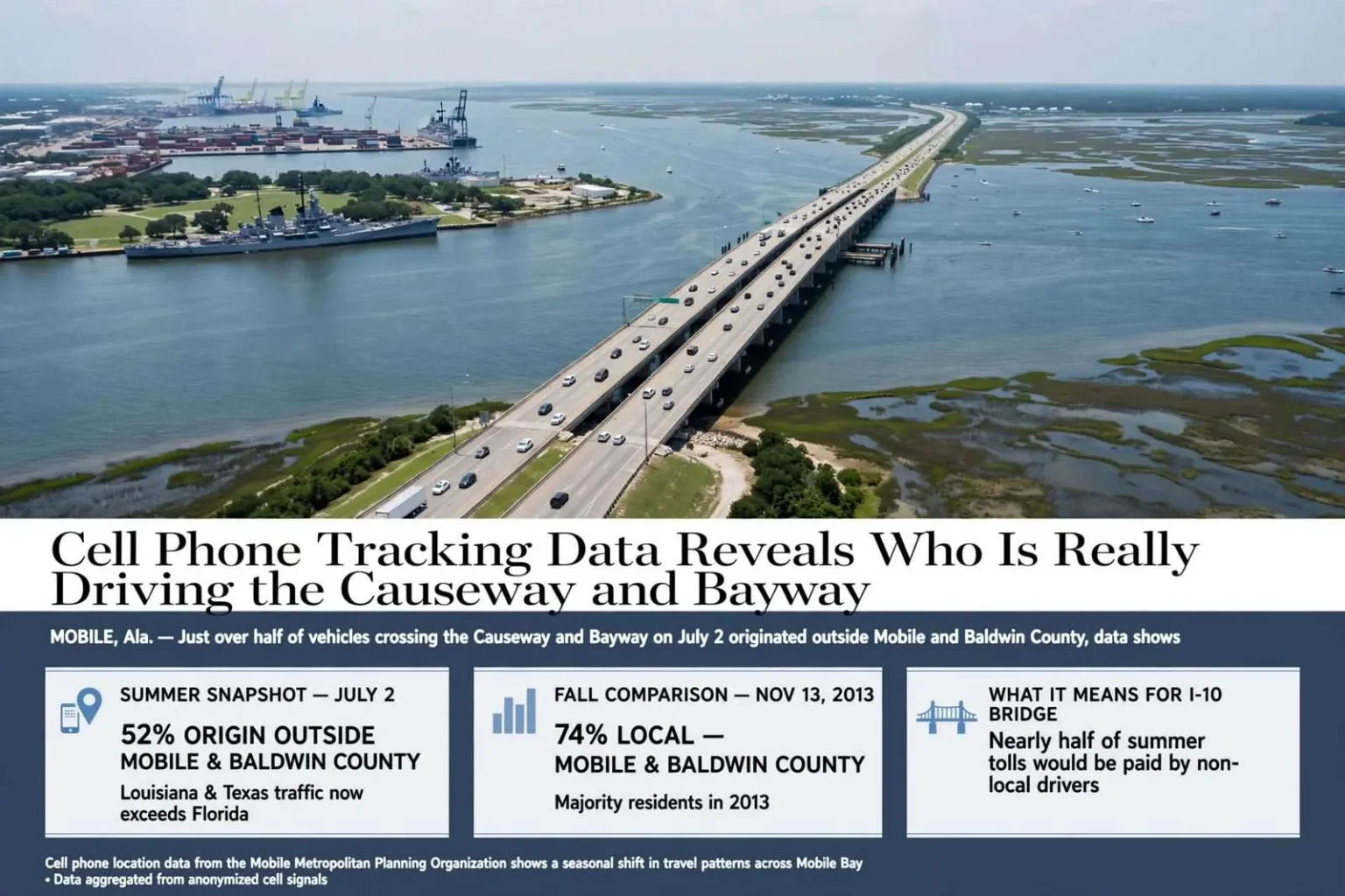
MOBILE, Ala. — Just over half of the vehicles crossing the Causeway and Bayway on a single day last month started their trip somewhere other than Mobile or Baldwin County, according to cell phone location data released by the Mobile Metropolitan Planning Organization. The figures, pulled from anonymized cell phone signals on July 2, show a sharp shift compared to a similar 24-hour snapshot taken on Nov. 13, 2013, when 74 percent of vehicles crossing Mobile Bay were driven by Baldwin and Mobile county residents. The comparison was designed to capture the difference between an average summer travel day and a typical fall Wednesday.
Kevin Harrison, director of transportation for the South Alabama Regional Planning Commission, which oversees the MPO, said he requested both data sets specifically to compare seasonal patterns. He acknowledged that the July date landed close to the Fourth of July holiday but said the numbers still offered a solid sample. According to Harrison, the results confirmed what transportation planners have long suspected — that during peak summer months, non-local traffic accounts for close to half of all trips across the bay.
For planners who spend their working days trying to model how the region moves, that kind of confirmation matters. Traffic counts alone can show how many vehicles cross the bay, but not where those vehicles began their trips or why. The cell phone data filled in that missing layer, separating the daily commuting patterns that dominate the fall calendar from the tourist and pass-through traffic that swells the corridor each summer.
What the numbers mean for the bridge debate
The data carries added significance for the long-discussed Interstate 10 Mobile River Bridge project, estimated at roughly $850 million, particularly as officials weigh whether tolls could help fund construction. U.S. Rep. Bradley Byrne has said tolls are unlikely to work as a primary funding mechanism, but Harrison said the tracking data gives planners a clearer picture of who would actually be paying if a toll system were adopted.
Any toll on a new span would fall on everyone who crosses the river, residents and visitors alike. If nearly half the summer traffic originates outside the two counties, a meaningful share of the toll burden in peak season would be borne by travelers who live elsewhere — a fact that changes the politics of tolling as much as the arithmetic. Tourist traffic that disperses the cost across Louisiana, Texas, Florida and beyond is a very different proposition from a toll paid almost entirely by Baldwin County commuters making the same crossing twice a day.
Interestingly, the summer data showed combined traffic from Louisiana and Texas outpacing traffic from Florida, challenging assumptions that beachbound Florida travelers dominate the corridor. The finding cuts against a comfortable local narrative. Planners and residents alike have tended to picture the summer crush as convoys of Florida-tagged vehicles funneling toward Gulf Shores and Orange Beach, but the tracking suggests a broader national draw, with long-haul visitors from the western Gulf crossing Mobile Bay on their way to and from the coast.
The findings also push back on criticism that a new bridge would primarily serve Baldwin County commuters: while Baldwin County residents make up the largest single share of Causeway and Bayway traffic, they still fall well short of a majority, accounting for about 37 percent of trips in the fall sample and roughly 31 percent in the summer sample.
Opponents of the bridge and its potential tolls have often framed the project as a subsidy extracted from Eastern Shore residents for the benefit of port and downtown interests, or conversely as a convenience built for Baldwin County at Mobile’s expense. The data complicates both framings. No single group of users comes close to a majority in either season, which means the corridor’s users are best understood as a shifting mix: local commuters in the fall, a genuinely national crowd of travelers in the summer, and freight and commercial traffic year-round.
How the tracking works
The tracking technology, provided by Atlanta-based AirSage, works by aggregating anonymous cell signal pings, generated by calls, texts and even automatic app updates, and estimating a device’s general location over time. Harrison emphasized that the data cannot identify individual users or their specific destinations, only broad location trends drawn from a massive pool of signals collected nationwide each day.
That anonymity is central to how the product works. Rather than following any one phone, AirSage’s system looks for statistical patterns across millions of devices, classifying trips by where they began and ended at the level of census tracts and counties. For a metropolitan planning organization charged with forecasting travel demand decades into the future, the method offers something traditional resources cannot: origin and destination data without the expense and sampling bias of household travel surveys or roadside interviews.
Cell-based estimates are not perfect. The approach depends on where phones are when they ping, and it must be calibrated against physical counts. But as a complement to the Alabama Department of Transportation’s counters, it gives planners a two-dimensional picture — how many vehicles crossed, and where they came from — that neither source provides alone.
The river crossings behind the numbers
Using average daily traffic counts from the Alabama Department of Transportation, the MPO estimated that more than 107,000 vehicles crossed the Mobile River via the Bankhead and Wallace tunnels and the Cochrane-Africatown USA Bridge on July 2, compared with about 96,500 vehicles on the November count date, though those totals include trips bound for Austal USA, BAE Systems and other river-adjacent employers not captured in the Causeway and Bayway analysis.
The distinction matters for anyone trying to model the bridge’s future traffic. The two tunnels and the bridge carry every kind of river crossing — workers heading to the shipyards, residents making local trips, and the long-distance travelers whose phones showed up in the Causeway and Bayway sample. Isolating the bay crossings gives planners a cleaner read on the trips a new span would actually serve, since the Causeway and the Bayway segment of Interstate 10 are the corridor a river bridge would parallel and relieve.
The roughly 10,000-vehicle difference between the summer and fall count dates also underlines the seasonal swing the cell data revealed. Nearly a tenth of the daily river-crossing volume appears or disappears depending on the time of year, and the trips most likely to vanish after Labor Day are precisely the non-local ones identified in the tracking sample.
A corridor under pressure
The George C. Wallace Tunnel and the older Bankhead Tunnel have carried Interstate 10 through downtown Mobile for decades, and both were built for a city and a travel market far smaller than today’s. On peak summer days the approach to the tunnels has become one of the region’s most reliable bottlenecks, backing up traffic from the Eastern Shore into downtown and sending Beach Express and Causeway-bound drivers hunting for alternates. The Causeway itself — the low, scenic Battleship Parkway crossing that predates the interstate — serves local traffic but cannot absorb overflow at interstate scale.
That is the backdrop against which the MPO’s study lands. The Mobile River Bridge has been discussed in one form or another for years as the long-term fix for the tunnels’ capacity problem, and the central questions have never been purely engineering ones. Where the money comes from, and who pays it, are the questions that have kept the project in the study phase rather than the construction phase, with tolling the most controversial of the options on the table.
By quantifying how much of the crossing traffic is non-local, the study gives both sides of that argument something concrete. Supporters of toll financing can point to the summer numbers as evidence that a large share of any toll would be paid by visitors rather than residents. Skeptics like Byrne, who have questioned whether tolls can carry the financing load, can point to the fall numbers, when local traffic dominates and the paying base shrinks back to the two counties.
What comes next
Harrison’s comparison of a single summer day and a single fall day is a snapshot, not a full-year model, and he has been careful to describe it that way. But snapshots are how regional transportation debates start to move. Origin-destination data of this kind feeds directly into the traffic and revenue studies that any major river crossing would need before state or federal money could be committed, and it gives local elected officials a defensible answer to the most common question constituents ask about the project: who, exactly, is going to use it.
For now, the numbers confirm the shape of the problem planners have long described. Mobile Bay is crossed every day by two distinct populations — a local one that commutes, shops and hauls freight between the counties, and a seasonal one that arrives from across the Gulf South each summer. Any solution that works for one but not the other will not survive contact with the data, and the MPO now has a far better idea of what both populations look like.