Foley Pedestrian Bridge Over Highway 59 Set to Go Out for Bid
Foley's long-planned pedestrian bridge over Alabama 59 near Heritage Park moved toward construction as the $1 million span went out for bid.
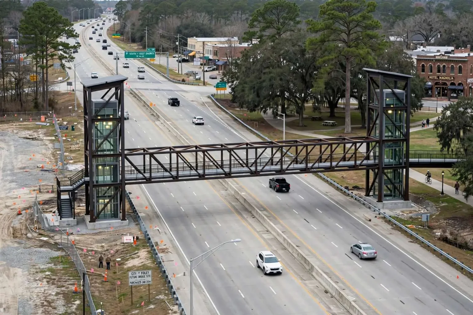
Four years in the making, the city of Foley moved a step closer to building a pedestrian bridge over Alabama 59 in January 2015, as the roughly $1 million span went out for bid to construction contractors.
City Engineer Chad Christian said the bridge, an 108-foot span supported by two 39-foot elevator-equipped towers, will cross Highway 59 about a block north of U.S. 98, connecting pedestrians and cyclists to Heritage Park near Jessamine Avenue and Hotel Magnolia.
The bridge’s western landing will sit on property the city purchased for $400,000 in early 2014 specifically to support the project.
Putting the project out for bid marked the transition from planning to procurement, the stage where designs become contract documents and contractors begin pricing the work. For a city that had spent four years assembling funding, land and engineering for the crossing, the bid solicitation represented the surest sign yet that construction was imminent.
The design itself reflects the demands of crossing one of Baldwin County’s busiest highways. Elevator-equipped towers rising 39 feet carry pedestrians and cyclists up and over the roadway, eliminating the need for long approach ramps that would consume land on both sides. The towers also make the bridge accessible to users who cannot manage stairs — a central consideration for a structure intended to serve the whole community, from schoolchildren to senior citizens.
The TIGER Grant Behind the Project
The bridge is part of a much larger $4.7 million federal Transportation Investment Generating Economic Recovery, or TIGER, grant awarded to Foley after the city applied for the competitive federal funding three years in a row.
As a condition of the grant, Foley is responsible for covering roughly 25 percent of the cost locally, an estimated $1.6 million match, bringing the total project cost associated with the grant to about $6.3 million.
TIGER grants are among the most competitive awards in federal transportation funding. Unlike formula programs that distribute money to states by statute, TIGER — administered by the U.S. Department of Transportation — puts projects from across the country into direct competition, judging them on criteria such as safety, economic competitiveness, livability and state of repair. Communities of Foley’s size compete against large metropolitan areas for the same pool, which is why the city’s persistence across three application cycles mattered.
The third attempt succeeded where the first two fell short, and the win validated the city’s argument that its plans represented exactly the kind of multi-modal investment the program was created to fund. Foley’s application tied the bridge and path network to downtown revitalization, tourism traffic and everyday safety — a package that fit the program’s livability goals.
The local match requirement is standard for major federal transportation awards, and Foley’s willingness to commit roughly 25 percent of the cost from local sources signaled the city’s own belief in the project. Matching funds of that scale, about $1.6 million, represent a significant investment for a city Foley’s size, financed through the kind of capital planning municipalities reserve for their highest-priority projects.
Foley TRIPS and the Path Network
The pedestrian bridge is the centerpiece of a broader five-year infrastructure initiative known as Foley TRIPS, short for Transportation Regional Infrastructure Pedestrian System.
The plan calls for adding 73 miles of new pedestrian and bicycle lanes and paths throughout the city over its life span.
Once complete, the TIGER-funded portion of the project alone is expected to expand the city’s pedestrian path network by 15 miles, bringing the total to 50 miles, while increasing bike paths, bike lanes, shared-use paths and greenways from roughly 3 miles to 17.5 miles.
Those numbers describe a fundamental reshaping of how people move around Foley. A city where walking and cycling accounted for only a handful of miles of dedicated infrastructure is building a network designed to make foot and bike travel a realistic option for daily trips — to school, to shops, to parks and to work.
The distinction among the path types matters for how the network functions. Shared-use paths and greenways carry pedestrians and cyclists together on routes separated from vehicle traffic, typically along parks, streams and utility corridors. Bike lanes stripe out space on existing streets, connecting the separated paths into a complete network. Together, the two approaches let the city extend its reach without buying land for every mile.
Heritage Park sits at the heart of the system, and the bridge’s connection to it is deliberate. The park — with its trails, fountain, amphitheater and event grounds — serves as Foley’s central gathering place, hosting concerts, festivals and community events throughout the year. Linking the park to neighborhoods west of Highway 59 through a dedicated crossing extends its reach to residents who currently face the highway barrier on foot.
The Hotel Magnolia, a restored landmark near the park in Foley’s historic downtown district, anchors the eastern side of the crossing. The city’s downtown revitalization effort, which has restored historic buildings and drawn shops and restaurants into the blocks around the railroad corridor, depends on foot traffic — and the bridge adds a population of walkers arriving from the west side of town.
Why Highway 59 Needed a Solution
City officials have framed the pedestrian bridge and the broader TRIPS network as an effort to make Foley more walkable and bike-friendly as the city continues to grow, connecting neighborhoods, parks and commercial areas without requiring residents to cross busy roadways like Highway 59 at grade.
The Highway 59 corridor through Foley has long been one of Baldwin County’s busiest commercial strips, particularly during the summer tourist season when traffic swells with visitors headed to the Gulf beaches.
The highway functions simultaneously as Foley’s main street and as a segment of the primary route from Interstate 10 to the coast, a combination that produces exactly the kind of traffic pedestrians are advised to avoid. Four- and six-lane traffic, frequent commercial driveways and turning vehicles make at-grade crossings hazardous even for experienced cyclists, and effectively impossible for children or elderly residents during peak season.
Foley’s summer traffic surge is a defining feature of the city. Positioned along the route beach-bound travelers take from the interstate, the city absorbs waves of visitors whose numbers swell restaurant seats, store lines and highway lanes alike. A pedestrian crossing that depends on traffic lights yields to that pressure; an elevated bridge does not, which is why city engineers chose to carry foot traffic over the highway rather than across it.
The safety case for the bridge rests on that arithmetic. Every crossing made on the bridge is a crossing that does not put a pedestrian or cyclist into the path of through traffic on a four-lane highway. For a city investing in a walkable future, removing the highway barrier was the precondition — no path network could function with its east and west halves severed by the busiest road in the county.
What Happens Next
With the bid solicitation set to open in early February 2015, city officials anticipated construction could begin later in the year, giving Foley residents and visitors a dedicated, elevated crossing over one of the city’s most heavily traveled roads within Heritage Park’s growing recreational footprint.
The bidding process will determine the contractor and, ultimately, the final construction cost. Municipal bids for a project of this scale typically draw regional contractors experienced in bridge and pedestrian infrastructure, and the city’s engineers will evaluate submissions on both price and qualifications before awarding the contract.
Construction of an elevated pedestrian span involves significant site work on both sides of the highway: foundations for the two 39-foot towers, the approach paths that feed them, and the placement of the 108-foot span itself. Work along an active highway corridor requires coordination with state transportation authorities, traffic control plans and phasing designed to keep vehicles moving while crews operate overhead.
For Foley, the timeline means the bridge could open while the larger TRIPS program is still in mid-course, delivering the initiative’s signature project ahead of the miles of paths that will eventually connect to it. Each new path segment added under the program extends the bridge’s reach, drawing users from farther neighborhoods into the network.
The project’s four-year journey — from the first grant application, through two rejections, to a successful $4.7 million award, a $400,000 land purchase and a January 2015 bid solicitation — illustrates the pace of infrastructure work in communities that fund it carefully. Every stage required patience: federal applications written and rewritten, local match money set aside, land acquired, designs drawn and finally, contractors invited to bid.
When the span is complete, the crossing will carry a nameless daily traffic of its own — joggers, families bound for the park, tourists walking from downtown hotels and cyclists threading between path segments. For a city that has spent four years and millions of dollars getting to this point, that ordinary stream of people on foot will be the measure of whether the project delivered what it promised.