
Storm Chances Fade This Week as Dangerous, Near-Triple-Digit Heat Builds Along the Gulf Coast
Storm chances fade later this week as high pressure builds over the Gulf Coast, pushing heat index values toward 110 degrees by Thursday and Friday.
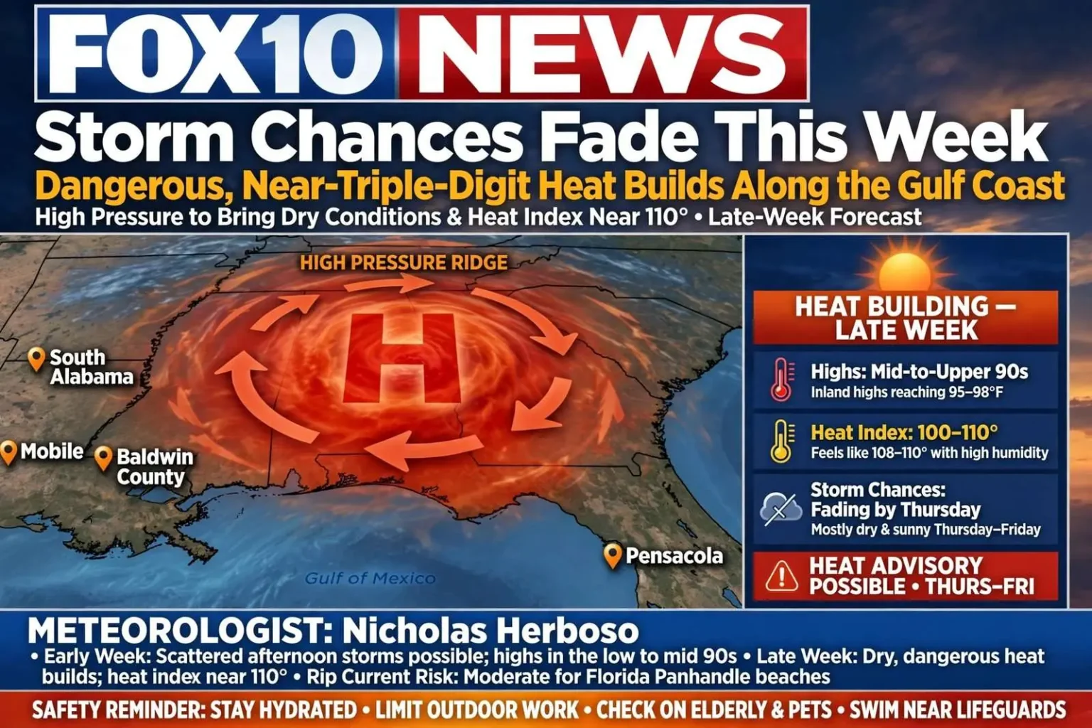
The Gulf Coast’s weather pattern is shifting from typical summer storminess to a stretch of dangerous heat, according to FOX10 News meteorologist Nicholas Herboso.
Early in the week, conditions remain fairly typical for South Alabama, with isolated afternoon storms possible and highs in the low to mid 90s. Heat index values are still expected to climb to between 100 and 108 degrees, a level meteorologists say is already a concern for anyone spending extended time outdoors.
That kind of summer start is familiar across the central Gulf Coast, where afternoon sea breezes collide with inland heat to fire off pop-up storms that drench one neighborhood and miss the next. But the familiar rhythm is about to change, and the change is toward something more hazardous than a passing downpour.
High Pressure Takes Over by Late Week
By late week, high pressure is forecast to strengthen and push storm chances down significantly. Thursday and Friday should turn mostly sunny and largely dry, with inland highs reaching the mid-to-upper 90s. Combined with the region’s characteristic humidity, heat index values could approach or exceed 110 degrees at times, a range that can trigger heat advisories or excessive heat warnings.
The mechanism is one forecasters see every summer: a strengthening ridge of high pressure aloft acts like a lid over the region, sinking air suppresses cloud and storm formation, and the sun’s energy accumulates day after day without the afternoon showers to knock temperatures back. What begins as a quiet stretch of weather becomes a dangerous one, because the heat that builds has no outlet — and humidity from the Gulf keeps the effective temperatures even higher than the thermometer shows.
Forecasters are urging residents to plan around the heat rather than push through it: take frequent breaks, stay hydrated and avoid peak afternoon hours for outdoor work, athletic practices and school events during the extended hot stretch.
The advice carries particular weight for the groups whose schedules don’t bend easily. Construction crews, roofers, landscapers and agricultural workers have no choice but to be outside, which makes the timing of their shifts critical during a heat event. High school and youth athletic programs across South Alabama, many of them opening fall practice during the hottest weeks of the year, follow state heat guidelines that govern practice times, equipment and hydration breaks — guidelines that exist precisely because exertion in 108-degree heat indexes can turn deadly.
Heat illness follows a predictable progression that everyone should know: cramps and heavy sweating give way to dizziness, nausea and headache, and those symptoms can escalate toward heat stroke, a medical emergency in which the body loses its ability to cool itself. Checking on elderly neighbors, keeping children and pets out of parked cars, and moving strenuous errands to early morning are the standard defenses — boring advice that saves lives every summer.
Rip Current Risk for Beachgoers
Along Florida Panhandle beaches, a moderate risk of rip currents is expected later in the week, and swimmers are advised to stay near lifeguards.
Rip currents are the Gulf Coast’s most persistent beach hazard, narrow channels of water flowing away from shore that can pull even strong swimmers into deep water. The safety guidance is consistent: swim where lifeguards can see you, don’t fight the current if caught — swim parallel to shore until free — and pay attention to the warning flags posted at public beaches. Clear skies and calm-looking surf can still hide dangerous currents, which is why the risk forecast matters even on days when the water looks inviting.
Tropics Stay Quiet — For Now
Tropically, the outlook stays quiet for now. Several systems in the Atlantic warrant routine monitoring but remain well away from the U.S., while the Gulf and Caribbean are expected to stay calm with no development anticipated in the near term.
The quiet Gulf is its own piece of good news for coastal residents from Mobile Bay to Pensacola. August sits at the doorstep of the season’s historical peak, when sea surface temperatures across the basin reach their warmest and the ingredients for rapid intensification are most often in place. Routine vigilance — reviewing supply kits, confirming insurance documentation, knowing evacuation zones — costs little during calm weeks and pays for itself the moment the map changes.
For now, forecasters say, the Atlantic disturbances pose no threat, and the basin that matters most to Gulf Coast residents is forecast to stay uneventful. The same high pressure that parks heat over South Alabama also tends to suppress tropical development nearby, a silver lining of the pattern that residents will take while it lasts.
The Week Ahead
The bottom line for the coming days: a brief window of scattered storm chances early in the week gives way to a longer run of dangerously hot, drier conditions as the week progresses — a pattern that tends to linger into the following weekend along the Gulf Coast.
The persistence is the part that wears people down. A single hot day is an inconvenience; five or six consecutive days above 100 degrees on the heat index strain power grids as air conditioners run nonstop, stress outdoor workers and athletes, and leave no overnight relief, because Gulf Coast humidity keeps nighttime temperatures elevated and prevents bodies and buildings from cooling.
Residents planning the week should treat the forecast in two halves. Early week offers the last comfortable window for yard work, outdoor projects and rescheduled activities, along with the chance of an afternoon storm to water the lawn. From Thursday onward, the smart plan shifts indoors: morning hours for anything that must be done outside, hydration planned as deliberately as the work itself, and a weather radio or reliable forecast app checked daily in case the heat pattern shifts or the tropical picture changes. The Gulf Coast’s summer has arrived in force — and this week, it plans to stay.
Herboso’s outlook gave South Alabama a rare luxury: several days of lead time before the worst of the heat arrives. Heat events are quieter than hurricanes and less photogenic than tornadoes, but they consistently rank among the deadliest weather hazards, precisely because their danger accumulates gradually and their victims are often working, practicing or simply living outdoors when the cumulative strain becomes too much. The forecasting office’s early and explicit warnings — with specific numbers and specific days — are designed to break that pattern before it starts.
For Mobile and Baldwin County residents, the forecast also reshapes everyday logistics in ways worth planning for. Vehicle interiors become dangerous within minutes in this kind of heat, groceries melt on the drive home, and afternoon errands are best saved for the evening or the following morning. Pool schedules, boat ramps and fishing piers shift toward dawn, and the pavement itself — asphalt in full sun can run far hotter than the air temperature — becomes a hazard for pets’ paws and bare feet alike.
Utility customers can expect demand to climb with the temperature, and the familiar advice applies with extra urgency during a multi-day event: set thermostats sensibly rather than frigidly, run major appliances in the cooler overnight and early morning hours, and close blinds against the afternoon sun. Small habits compound across a five-day heat wave, both on the bill and on the grid that every neighbor’s air conditioner depends on.
The early-week storms, meanwhile, come with their own standard Gulf Coast caveats. Summertime cells here can turn violent briefly — frequent lightning, gusty outflow winds and localized downpours that flood low-lying streets — before dissolving as quickly as they formed. Boaters and beach visitors should treat any approaching dark cloud with respect, since lightning can strike well ahead of the rain core, and the same trip to the water that beats the heat can put you directly under the day’s most dangerous weather.
School administrators across the region watch forecasts like this one closely, since the heat stretch coincides with a period when band camps, fall sports conditioning and outdoor orientations fill the calendar. Decisions about moving practices to morning hours, adding hydration breaks and monitoring athletes for heat illness are made with the forecast’s specific numbers in hand — and with the knowledge that heat indexes near 110 leave little margin for error in uniforms and pads.
The extended outlook offers hope beyond the weekend, but no promises. Summer heat ridges over the Gulf Coast typically break down as disturbances eventually undercut them, restoring the daily storm cycle, though the timing of that shift remains uncertain this far out. Until the pattern changes, the forecast’s message stays the same: respect the heat, plan around it, and let the quiet tropics stay quiet.
One more reminder bears repeating for the weekend boaters and beach crowds who will be out in force: sunscreen, shade and water are not optional accessories in this pattern. The same sunshine that drives heat indexes past 110 delivers sunburn that accelerates dehydration and heat exhaustion, and the combination of a few sensible precautions is what turns a dangerous week into a merely hot one.