MOBILE, Ala. — Evening thunderstorms are expected to weaken across the central Gulf Coast, but the oppressive heat and humidity that have defined recent days show no sign of easing. The forecast delivers a familiar August trade-off: fewer storms to dodge, but heat that remains hazardous for anyone spending long stretches outdoors.
After showers and storms clear out overnight, forecasters expect a quieter but muggy night. Overnight lows will settle in the upper 70s, keeping conditions feeling sticky well after sunset. For residents without reliable air conditioning, and for those working outdoors into the evening hours, the warm nights offer little chance for the body to recover from daytime heat.
Thursday: Dangerous Heat With Afternoon Storms Possible
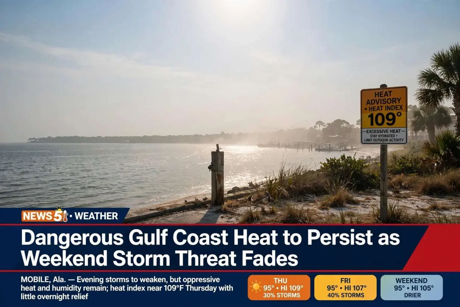
Thursday brings more of the same combination of heat and humidity. Highs are expected to reach the mid-90s, but the bigger concern is the heat index, which could climb to around 109 degrees. That level of heat can be dangerous for anyone spending extended time outdoors, and health officials typically urge limiting strenuous activity to early morning or evening when heat indices climb past the mid-100s.
There is also a 30% chance of scattered showers and thunderstorms during the day. While most of the area is likely to stay dry, any storms that do form could be strong. The typical August pattern puts storm development in the afternoon and early evening, as daytime heating fuels cells over the land and pushes them toward the coast.
When heat indices approach 110 degrees, the combination becomes a genuine health concern rather than a comfort issue. Heat exhaustion can set in quickly during outdoor work or exercise, and the region’s road crews, construction workers, roofers and agricultural workers face the greatest exposure. Residents are encouraged to check on elderly neighbors and to never leave children or pets inside parked vehicles, where temperatures can climb to lethal levels within minutes.
Friday: Slightly Higher Rain Chances
Friday looks similar to Thursday, with temperatures in the mid-90s and a 40% chance of showers and thunderstorms as a front approaches the region. The heat index will remain elevated, though slightly lower than the day before.
The approaching front is the key to the weekend forecast. As it slides toward the Gulf Coast, it raises the chance of afternoon storms while setting up drier and slightly less humid air behind it. Friday’s storm coverage, in other words, is the transition point between the sweltering pattern of recent days and the modest relief that follows.
Schools and athletic programs across the central Gulf Coast typically adjust outdoor practice schedules when heat indices reach these levels, shifting workouts to mornings or moving activities indoors. The first weeks of fall sports season overlap with the hottest stretch of the year, making heat safety a routine part of August planning for coaches and athletic trainers throughout Mobile, Baldwin and surrounding counties.
Weekend: Drier With a Bit of Relief
The weekend brings welcome news: a break from the daily storm threat. Saturday and Sunday should see very low rain chances, giving the area a reprieve from the scattered evening storms that have been popping up recently. Highs will still reach the mid-90s, but slightly lower humidity should make the heat index more manageable, dropping to around 105 degrees — still hot, but an improvement over earlier in the week.
The drier air makes a noticeable difference in how the heat feels. At 105 degrees on the heat index, outdoor activity remains demanding, but the reduced humidity allows sweat to evaporate more effectively, easing the strain on the body compared with days when the index climbed near 109. Weekend plans such as fishing trips, yard work and youth sports are safer to schedule, though shade, hydration and frequent breaks remain important.
Boaters and beachgoers will also appreciate the calmer pattern. With storm coverage nearly absent, the weekend offers some of the most reliable conditions of the month for excursions on the bay and Gulf, provided visitors continue to observe heat precautions.
Early Next Week: Above-Normal Heat Continues
Typical August conditions are expected to continue into early next week, with above-normal temperatures and spotty showers and storms returning to the forecast. The brief weekend reprieve, in other words, does not signal the end of summer’s pattern — it simply interrupts it.
August along the central Gulf Coast historically delivers some of the year’s hottest heat indices, and this pattern fits squarely within that seasonal norm. Relief of a more permanent kind usually waits on the first substantial cold fronts of autumn, which rarely reach the Gulf Coast before late September or October.
Beach Conditions and Rip Currents
Rip current chances have been moderate in recent days due to westerly winds, but those chances are expected to decrease, especially by Friday and through the weekend. Even along the coast, the improving wind pattern should make for calmer surf conditions as the week progresses.
Rip currents remain the most significant weather-related hazard on the Gulf Coast, accounting for more rescues and fatalities each year than storms themselves. The channels of fast-moving water pull swimmers away from shore, and the standard advice stays the same regardless of the forecast: swim near a lifeguard where one is posted, and if caught in a rip current, do not fight it directly — swim parallel to shore until free of the pull, then angle back toward the beach.
Westerly winds, which have driven the elevated risk in recent days, push water along the shoreline and can strengthen the currents near passes and sandbars. As winds relax into the weekend, the flag conditions on local beaches should improve, but conditions can change quickly, and swimmers should check the day’s beach flags before entering the water.
What the Pattern Means for Residents
The week ahead is a study in August trade-offs along the central Gulf Coast. Storm chances rise slightly through Friday as a front approaches, then collapse for the weekend, while the heat index eases only modestly from near 109 to around 105 before settling into an above-normal early-week pattern.
For most residents the practical guidance changes little from day to day: limit outdoor exertion during peak afternoon hours, hydrate steadily, keep pets and children out of parked vehicles, and monitor the afternoon sky for the storms that do develop, since even a 30% or 40% storm chance in August can produce a strong cell with little warning at any given location.
Utility demand also tends to run high during stretches like this one, as air conditioners labor around the clock against the upper-70s overnight lows and mid-90s afternoon highs. With the hot pattern extending at least into early next week, the region’s summer electric bills will continue to reflect the relentless demand.
Staying Safe Through the Stretch
Emergency managers across the central Gulf Coast emphasize the same fundamentals whenever heat indices push past 105 degrees. Drink water before thirst sets in, wear light-colored loose clothing, and take shade breaks every 30 minutes or so during outdoor work. Early signs of heat illness — dizziness, nausea, headache and cramping — should prompt an immediate move to a cooler environment.
Vehicles deserve particular attention during this pattern. A car parked in the August sun can become dangerous within minutes, and the upper-70s overnight lows mean that even evening hours offer limited cooling for interiors left in the sun.
Pet owners should plan walks for the early morning or after sunset, both to spare animals the heat index and to protect their paws from pavement that stays hot well into the evening. Asphalt and concrete surfaces absorb the afternoon heat and release it slowly, and on days when air temperatures reach the mid-90s, pavement surface temperatures can run far higher.
Local marinas and charter operators track these patterns closely as well, since weekend conditions determine how much of the fleet gets out. With very low rain chances and improving surf, the upcoming weekend shapes up as one of the better windows of the month for bay and nearshore trips, and the reduced rip current risk extends that improvement to swimmers and surf anglers along the beaches.
The Week at a Glance
To summarize the forecast: a quieter, muggy night with lows in the upper 70s; Thursday with mid-90s highs, a heat index near 109 and a 30% storm chance; Friday similar with a 40% storm chance as a front approaches; a dry weekend with lower humidity and heat indices around 105; and above-normal heat with spotty storms returning early next week. Rip current chances, moderate in recent days under westerly winds, should ease by Friday and through the weekend.
The message from the pattern is simple. Storms will take a break, but the heat will not, and residents of the central Gulf Coast should plan their outdoor time around the most dangerous hours of the day until a more substantial shift in the weather arrives.