Jackson County storm debris could become airborne in high winds
Storm debris in Jackson County, Mississippi could be thrown by high winds as another round of severe weather approaches.
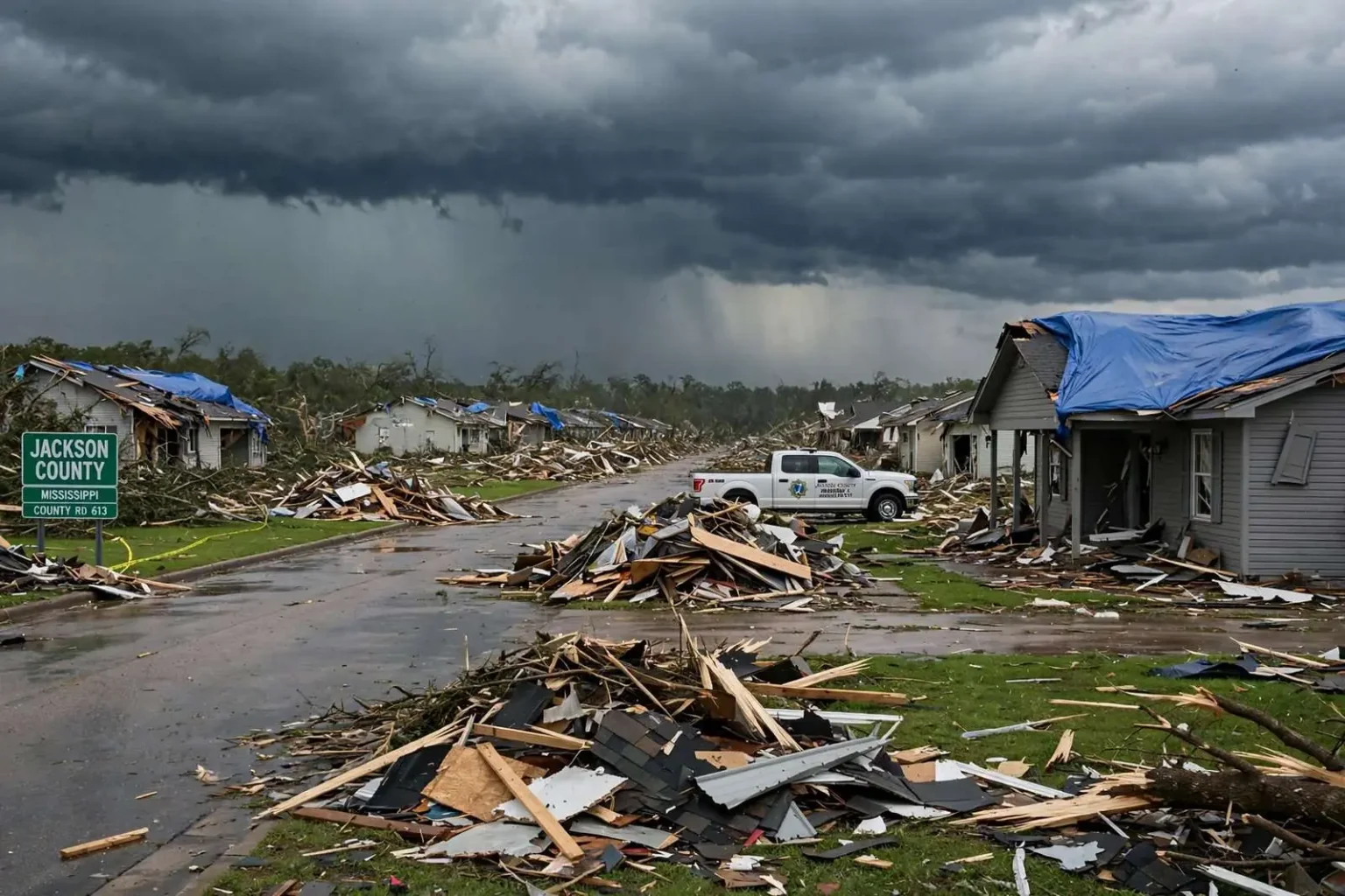
Storm debris still littering parts of Jackson County, Mississippi, after a tornado struck last week is raising new dangers as more severe weather bears down on the area. Pieces of trees and homes damaged in last week’s tornado could easily be picked up by high winds and hurled at high speed toward other homes, cars and even people, according to local reporting. Emergency officials point out that debris fields left by a tornado are not just a cleanup problem — in the right conditions, they become a supply of airborne projectiles that can turn a secondary storm into a second disaster.
The concern is not theoretical. Meteorologists have long warned that the most common source of injury in any tornado or severe thunderstorm is flying debris, and neighborhoods still buried in broken limbs, splintered lumber and shredded roofing material have far more of it on hand than they would after an ordinary storm. What was shrapnel’s raw material last week is ready-made ammunition this week, and winds strong enough to move it can arrive with very little notice in fast-moving squall lines.
A second problem is that several homes still have tarps covering holes in their roofs. With heavy rain on the way, that could mean further damage to those homes. Tarps are designed as a temporary stopgap, buying homeowners time until permanent repairs can be made, and they are never meant to withstand repeated rounds of wind-driven rain. A tarp that pulls loose or shifts in high winds can expose a damaged roof deck within minutes, letting water pour into attics, insulation and living spaces that were already compromised.
For families still putting their lives back together, the forecast adds a psychological weight that is easy to overlook. Residents who have spent the week dragging debris to the curb, filing insurance claims and deciding what can be salvaged now have to consider whether the work they have done will be undone. Recovery workers and volunteers face the same math, since piles meant for pickup sit exposed in yards, and cleanup schedules can be thrown off entirely when a new round of weather moves through before the debris is hauled away.
Officials urge residents in storm-damaged areas to take the incoming weather seriously: secure or anchor loose material where possible, move vehicles away from large limbs and damaged trees, keep phones charged and weather alerts turned on, and be ready to move to a safe interior room if a warning is issued. In neighborhoods where damage has already occurred, those basic steps matter even more than usual, because the hazards that come with the next storm are already lying in every yard.
Why debris becomes the danger
Damage surveys after tornadoes consistently find that it is rarely the wind itself that injures people — it is what the wind picks up. Studies of tornado and hurricane damage have shown that ordinary objects become lethal at surprisingly low wind speeds, and structurally failed building materials are among the worst offenders. A piece of roof decking or a large limb can travel a block or more in a strong thunderstorm’s gusts, striking with enough force to break windows, punch through siding or injure anyone caught outside.
Jackson County, which stretches along Mississippi’s Gulf Coast from the Alabama line west toward the Biloxi area, knows this cycle well. The county sits in one of the most tornado-prone corridors of the United States — the swath of the Deep South that sees dangerous storms in every season, but especially in the fall and spring. Gulf Coast communities face a long list of storms in their history, and the county’s recovery from past hurricanes and tornadoes has made debris management a familiar, if unwelcome, part of the local playbook.
Debris removal after a tornado is a staged operation. Crews typically separate vegetative material, construction and demolition debris, white goods and household hazardous waste into different streams so each can be processed or disposed of properly. Contractors with grapple trucks and hauling fleets work street by street, and the sheer volume a single tornado can generate — often measured in thousands of cubic yards per mile of damage — means the process takes weeks even under the best conditions. Storms that interrupt the work add volume, scatter collected piles and reset parts of the schedule.
The tarp problem
The blue tarps stretched over damaged roofs across the county are a visible sign of how much repair work remains. Roofing contractors across the Gulf Coast stay booked for months after a damaging tornado, and homeowners who cannot get a crew scheduled quickly rely on tarps to keep water out of the house. Insurance policies generally require homeowners to make reasonable temporary repairs to prevent further damage, so the tarps serve both a practical and a paperwork purpose — but they are a bridge, not a solution.
Wind is the tarp’s enemy. A properly installed tarp is anchored by strapping or wrapped boards on the roof, but sustained gusts and airborne debris can loosen even a careful installation. Once a corner peels back, wind gets underneath and the covering can be torn away entirely, along with any shingles still holding at the damaged edge. Rain then reaches the interior through the original hole and any new ones the tear creates, turning a covered claim into a larger one and forcing families who have already been through one disruption to face repairs all over again.
Getting ready for the next round
Residents in the damaged areas can take several practical steps before the next storm arrives. Loose debris that can be safely moved — small limbs, metal roofing fragments, yard items — should be secured or brought inside if a pickup has not yet reached the street. Vehicles should be parked away from trees and damaged structures where possible. Tarps should be checked for loose edges and re-secured if wind has started to lift them, though no one should be climbing onto a damaged roof in dangerous weather. Trash cans, grills and furniture that can become projectiles in their own right belong inside or anchored down.
Communication is the other half of the preparation. A NOAA weather radio remains the most reliable way to receive warnings in the middle of the night, particularly in areas where cell coverage can be spotty, and the wireless emergency alerts built into modern phones provide another layer. Families in storm-damaged neighborhoods should know where they will go if a warning is issued — a windowless interior room on the lowest floor is the standard guidance — and should keep shoes, flashlights and helmets near that space, since navigating debris-strewn homes in the dark after a storm is itself a hazard.
Emergency management officials in the county have emphasized that the community’s recovery is progressing, but that progress and preparedness are not alternatives. The same streets where crews are working are the streets where residents need to stay alert, and a community that has just been hit is, by definition, a community with less margin for error when the sky darkens again.
Looking past the storm
Once the current threat passes, the work of recovery resumes, and the county’s experience with Gulf Coast disasters suggests the path forward. Insurance adjusters, roofing crews, tree services and debris haulers will remain busy for weeks, and homeowners are encouraged to document damage thoroughly — with photos and written records — before and after any repairs, both for claims and for any state or federal assistance that becomes available. Local officials typically coordinate with state emergency management to assess whether damage totals qualify for additional aid programs.
The lesson of back-to-back storms is one Gulf Coast residents have learned before: recovery is not a straight line. A tornado damages a neighborhood, the community mobilizes, and then the weather tests the work before it is finished. Jackson County has done this before, and the coming days will demand the same mix of caution, patience and persistence that every recovery along the Gulf requires — starting with getting through the next round of severe weather safely.
The fall tornado season on the Gulf Coast
Much of the public’s attention to tornadoes focuses on spring, but the Gulf South’s second severe weather season arrives in late fall, when clashing air masses and strengthening jet streams over the region produce some of the year’s most dangerous storms. Meteorologists have documented that the corridor from east Texas through Mississippi and Alabama sees a pronounced peak of tornado activity in November and December, and fast-moving squall lines that develop over the Gulf can push warnings on communities with only minutes of lead time.
That timing collides directly with recovery operations in places like Jackson County. Crews clearing debris, adjusters inspecting roofs and contractors ordering materials all become part of the storm-day landscape, and residents who have been focused on paperwork and repairs can be caught without the weather awareness they would have had in a quieter season. Emergency managers use every channel available — social media, sirens where they exist, and local media — to remind residents that a damaged community cannot let its guard down.
For now, the priorities in Jackson County remain straightforward: finish the cleanup as quickly and safely as the weather allows, keep the tarped roofs holding until permanent repairs can be made, and get through the approaching round of storms without adding to last week’s toll. The debris that lines the county’s streets is a reminder of what the last storm did — and, in high winds, a warning about what the next one could do unless it is hauled away in time.