Severe Weather Damage Reports Across the Gulf Coast Region
A line of severe thunderstorms prompted tornado warnings and left damage across the Gulf Coast, from Florida to Mississippi.
A strong line of severe thunderstorms pushed across the Gulf Coast region in the early Sunday morning hours, setting off tornado warnings in multiple states and leaving a trail of downed trees, damaged power lines and flooded roads by daybreak. Damage reports streamed into the National Weather Service from communities across south Alabama, the western Florida Panhandle and south Mississippi as the squall line marched inland off the Gulf of Mexico.
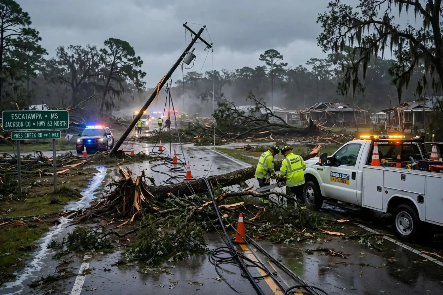
Hardest hit in the overnight hours were communities along and near the Alabama-Mississippi line, where radar showed rotation within the storm line and forecasters issued repeated tornado warnings. Law enforcement reported multiple homes damaged near Escatawpa, Mississippi, and emergency crews in south Alabama spent the morning cutting fallen trees out of roads and restoring electricity to darkened neighborhoods.
Damage reports across south Alabama
In Brewton, trees and powerlines were down on Sowell Road and Douglas Lane around 6:30 a.m., leaving parts of the Escambia County city without power as the storm line cleared the area. Farther west in Riverview, multiple trees were down and power outages were reported around the same early morning hour. In Berrydale, just across the state line in Florida, crews reported multiple trees down and power outages around 6:45 a.m., a sign that the same band of storms was raking both sides of the border as it moved northeast.
The Mobile Bay area saw its own share of overnight trouble. Spanish Fort Police reported a tree down across Highway 31 at Ember Lane around 4:14 a.m., blocking one of the Eastern Shore’s main thoroughfares during the pre-dawn hours. In Saraland, a tree and power lines were down on Leon Street around 3:55 a.m., according to the National Weather Service, adding to a growing list of wind damage reports logged across Mobile County as the line passed through.
Flooding on roads and campus
Heavy rain accompanied the wind. Roadway flooding was reported on Alabama 5 in both directions at milepost 11 near Alabama 10 in Pine Hill, with moderate delays expected as water stood across the pavement in rural Wilcox County. Drivers were urged to avoid the stretch until the water receded, and the report served as a reminder that flash flooding often lingers well after the storms that cause it have moved on.
In Mobile, minor flooding was reported on the University of South Alabama’s campus around 4:13 a.m., with running water pooling in parking lots as the storms passed over the midtown district. The area received almost 2 inches of rain in about an hour, a rate that quickly overwhelmed storm drains and turned low-lying pavement into shallow ponds. No injuries were reported in connection with the campus flooding.
The burst of overnight rain was consistent with the way Gulf Coast squall lines typically behave, training heavy bands over the same communities in a short window and dropping rainfall totals that can approach monthly averages in a single night. Forecasters noted that saturated ground from the downpours makes trees more vulnerable to toppling in strong winds, which helps explain the sheer number of tree reports across the region.
Radar-indicated tornadoes in Mississippi
In Mississippi, the storm line turned more dangerous. Law enforcement reported trees down blocking roads at Prescott Drive and Riverlodge Drive near Escatawpa around 3:44 a.m., in connection with a radar-indicated tornado at 2:52 a.m. Minutes later, around 2:55 a.m., radar indicated a likely tornado near the crossroads of Wildwood Road and Highway 63 north of Escatawpa, and law enforcement reported multiple homes damaged in that area as well.
Radar-indicated tornadoes are those where meteorologists see strong rotation and debris signatures on Doppler radar but lack confirmed visual sightings in the dark overnight hours. Morning light and damage surveys are what turn those warnings into confirmed tornado ratings, and crews in Jackson County were expected to assess the home damage once conditions allowed.
How the warnings unfolded
The overnight sequence followed a pattern Gulf Coast residents know well. The National Weather Service office responsible for south Alabama and the western Florida Panhandle issues tornado watches when conditions favor rotating storms, then individual warnings as rotation is detected or reported. Tornado warnings that arrive between midnight and sunrise are among the most dangerous, because most people are asleep and few storms are visible until they are already on top of a community.
That is why emergency managers across the region repeatedly urge residents to have multiple ways to receive warnings — a NOAA weather radio, phone alerts and local media — and to know where they will shelter before a warning is issued. A mobile home or a vehicle is a poor shelter in a tornado, and officials recommend moving to a interior room on the lowest floor of a sturdy building until the warning expires.
The timing of this event, with warnings and damage reports clustered between roughly 2:50 a.m. and 6:45 a.m., underscores how quickly a squall line can traverse the region. Storms that form over the Gulf can cross coastal counties in a couple of hours, meaning communities from Escatawpa to Brewton faced threats within a single overnight window even though they are separated by more than a hundred miles of highway.
A familiar Gulf Coast pattern
Severe weather outbreaks of this kind are a fixture of late winter and spring along the northern Gulf Coast, when warm, humid air flowing north from the Gulf collides with stronger systems moving in from the west. The region sits at the northern edge of what climatologists sometimes call Dixie Alley, a stretch of the Southeast that experiences a significant share of its tornadoes at night and in the cool season, when warning lead times tend to be shorter and populations less prepared than in the Plains.
Wind damage from squall lines, like the tree and powerline reports logged across the Gulf Coast this Sunday, is actually far more common than tornado damage in most events. Straight-line winds from a fast-moving line of thunderstorms can exceed 60 or 70 miles per hour, snapping pines and oaks whose shallow roots sit in saturated soil. Distinguishing between straight-line wind damage and tornado damage is a core job of National Weather Service damage survey teams, which look at the direction trees fell, the width and continuity of the damage path, and debris patterns on the ground.
Utilities and crews working to restore power
Power outages scattered across the affected counties kept utility crews busy through the morning. Fallen trees and limbs are the leading cause of storm outages along the Gulf Coast, often dragging power lines down with them when they fall. Residents are reminded that any downed line should be treated as energized, kept clear of and reported to the utility rather than approached, since lines can remain dangerous even when they appear dead.
Local road departments also spent the morning clearing blocked roads like those in Escatawpa, where trees blocked residential streets, and along rural highways such as Alabama 5, where standing water and downed debris narrowed travel. Officials asked drivers to give crews room to work and to avoid driving through flooded stretches, where just a foot of moving water can float a vehicle.
What comes next
The National Weather Service was expected to review radar data and ground reports in the coming days to determine which cells produced confirmed tornadoes and which produced straight-line wind damage. Surveys of the damaged homes north of Escatawpa will determine whether the radar-indicated rotations there are upgraded to confirmed tornadoes and assigned ratings on the Enhanced Fujita scale.
Residents with storm damage were encouraged to report it to local emergency management or the weather service, since public reports help forecasters confirm warnings, document the event and improve future warnings for the region. As the cleanup proceeded, no serious injuries had been reported across the affected areas, a result officials attributed in part to the overnight warnings that gave residents time to take shelter before the worst of the line arrived.
Sunday’s storms also served as an early-season tune-up for the region’s emergency response network. County emergency management agencies coordinated with fire, police and public works departments to clear roads and check on damage, while schools and churches in affected communities used social media to relay road closures and power restoration updates. Experience from past Gulf Coast outbreaks has shown that the hours right after a storm line passes are when most secondary injuries occur, typically from downed lines, chainsaw accidents and drivers striking debris, which is why officials continued asking residents to stay off damaged roads until crews finished clearing them.
For a region that measures its spring by how many nights the weather radio sounds, the event was a reminder of both the risk and the routine. The Gulf Coast’s severe weather season runs through the spring, and forecasters caution that the same ingredients — Gulf moisture, strong winds aloft and a lifting weather system — will come together again before the season ends. Sunday’s quick-moving line left broken limbs and dark traffic signals in its wake, but the overnight warnings, the early damage reports and the morning cleanup all followed the script that has kept the region’s tornado death toll low in recent years despite its exposure.