2011 Offshore Earthquake Was Felt Along the Alabama Coast
A 3.5-magnitude earthquake struck about 10 miles off Baldwin County in February 2011, with residents from Orange Beach to Dauphin Island reporting light shaking.
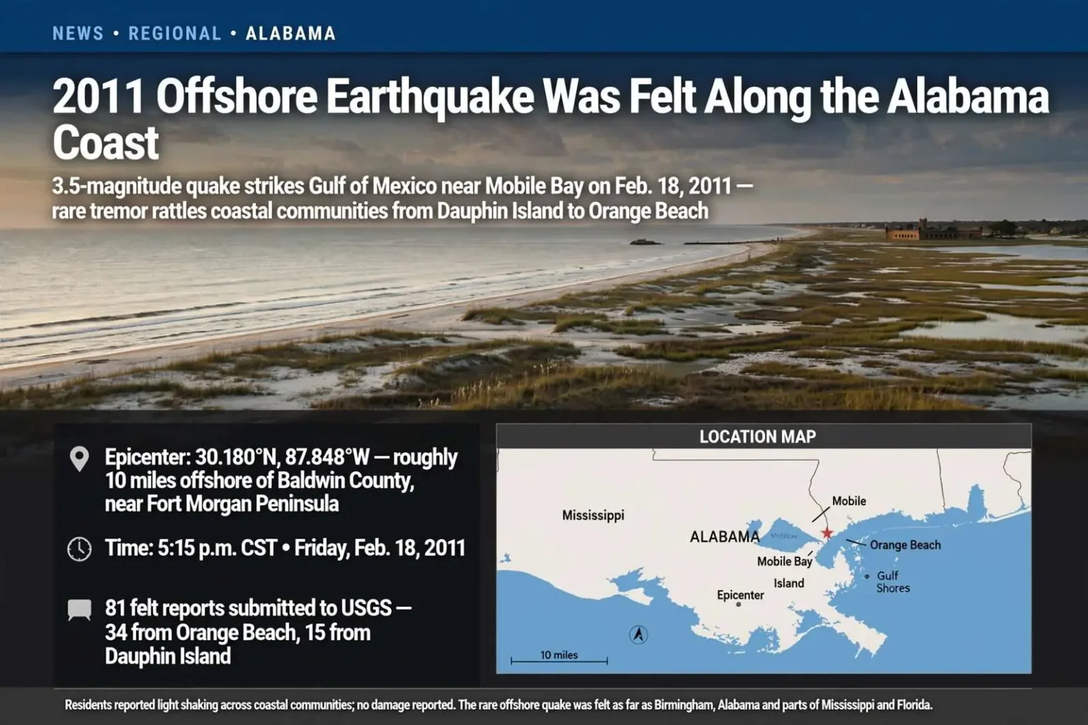
Residents along the Alabama coast reported light shaking after a 3.5-magnitude earthquake struck in the Gulf of Mexico on Feb. 18, 2011. The U.S. Geological Survey placed the 5:15 p.m. earthquake at approximately 30.180 degrees north latitude and 87.848 degrees west longitude. Its epicenter was less than 10 miles off the Baldwin County coast, near the end of the Fort Morgan Peninsula and the entrance to Mobile Bay.
The quake, modest by the standards of the world’s seismic hotspots, was nonetheless an unusual event for the Alabama Gulf Coast, where earthquakes are rare enough that many residents had never felt one. The late-afternoon timing — 5:15 p.m., with people at home or heading home for the evening — meant thousands of coastal residents were settled into kitchens and living rooms when the ground began to move, and reports of light shaking quickly followed from communities on both sides of Mobile Bay.
The epicenter’s location put it just offshore of one of Baldwin County’s most recognizable landmarks: the Fort Morgan Peninsula, the narrow strip of sand and marsh that extends west from Gulf Shores toward the historic fort at its tip, guarding the eastern approach to Mobile Bay. An epicenter in those waters placed the quake within easy feeling range of communities along both the Gulf front and the bay shores, from Fort Morgan and Gulf Shores across the bay to Dauphin Island and up into the populated corridors of Baldwin and Mobile counties.
Reports from coastal communities
People in several coastal communities said they felt the movement. A Dauphin Island resident described a home on pilings swaying for several seconds, while a resident of Orange Beach reported feeling shaking in a second-floor condominium. The U.S. Geological Survey received 81 reports of light shaking. Orange Beach accounted for 34 of those reports and Dauphin Island for 15.
The descriptions matched the way offshore earthquakes typically manifest in coastal buildings. Homes on Dauphin Island are commonly built on pilings to ride out storm surge and tides, and elevated structures amplify even mild ground motion into a noticeable sway — the sensation the island resident described. Multi-story condominiums in Orange Beach respond the same way, with upper floors moving more than ground-level rooms, which is why the beach city’s high-rise dwellers reported the shaking so consistently.
The report tallies told their own geographic story. Orange Beach, at the eastern end of the Alabama coast, and Dauphin Island, the barrier island guarding the bay’s western edge, together produced nearly half of all reports filed with the USGS, suggesting the strongest felt effects clustered in the coastal communities nearest the epicenter. The USGS “Did You Feel It?” system, which collects public reports through its website and maps their intensity, has become the agency’s primary tool for gauging how earthquakes affect populated areas, often capturing community-level detail that sparse seismometer coverage cannot provide.
Reports extended beyond the immediate coast, with people saying they felt the quake in locations as distant as Birmingham, Port Richey in Florida and Saucier in Mississippi.
That spread — reaching north to Alabama’s largest city, east to Florida’s Gulf Coast, and west into southern Mississippi — illustrated how efficiently the Gulf’s geology can transmit even a small quake’s energy. Earthquake waves travel through rock and sediment with little attenuation over long distances, and the sediments of the Gulf Coastal Plain are particularly good at carrying low-frequency shaking far from the source. A 3.5-magnitude quake that most Alabamians slept through in terms of damage was still distinct enough to be noticed by residents hundreds of miles apart.
What experts expected
Gene Longenecker, the Southeast Earthquake Program Manager for FEMA and a Mobile native, said small offshore earthquakes in the region generally produced light shaking rather than major damage. The event served as a reminder that the Gulf Coast can experience seismic activity even though large earthquakes are uncommon there.
Longenecker’s position put him at the center of federal earthquake preparedness work across the Southeast, a region that sits far from the Pacific Ring of Fire but is not without its own seismic character. As a Mobile native monitoring an earthquake just off his hometown’s shore, he was also well placed to translate the science for local audiences: the Gulf’s quakes are typically small, the damage minimal, and the appropriate response awareness rather than alarm.
The Gulf of Mexico’s seismic activity stems from ancient faults buried deep beneath layers of sediment, some related to the rifting that separated North America from other landmasses hundreds of millions of years ago, others tied to the slow settling and compaction of the enormous sediment loads deposited by rivers like the Mobile. Most of the region’s quakes register at magnitudes too small to be felt. When one does break into public awareness, it is almost always as a curiosity — a rattling of windows, a swaying chandelier, a rush of calls to radio stations — rather than a disaster.
That said, seismologists caution that rarity is not the same as impossibility. The Gulf Coast’s most consequential historical seismic connection lies to the north: the New Madrid seismic zone, centered near the intersection of Missouri, Kentucky, Tennessee and Arkansas, produced some of the largest earthquakes in American history in 1811 and 1812 and remains capable of damaging quakes that would be felt deep into Alabama. The southern Appalachians and the South Carolina Lowcountry, site of the destructive 1886 Charleston earthquake, also contribute to the Southeast’s seismic map. Against that backdrop, a 3.5-magnitude Gulf quake is a small event — but a reminder that the ground beneath the coast does move.
Not the first local quake
Reports at the time noted that the previous earthquake in the area had occurred on March 22, 2005. That earlier event measured 3.3 in magnitude and had an epicenter in Coffeeville.
The Coffeeville reference pointed inland rather than offshore. Coffeeville sits in Clarke County, north of Mobile along the Tombigbee River, and its 2005 quake was part of a cluster of small earthquakes that drew attention to the rural area in the middle of the last decade. The comparison between the two events — one inland, one in the open waters near Mobile Bay’s mouth, both in the mid-3s — gave seismologists and emergency managers a useful data point: small earthquakes were occurring on both sides of the coastal plain within a six-year span, even if none caused damage.
The 2005 quake’s Coffeeville epicenter became a talking point among regional geologists, who noted that southwestern Alabama’s sedimentary layers can amplify shaking and make even modest events noticeable across a wide area. The 2011 offshore event reinforced the same lesson from the other direction, arriving from beneath the Gulf and making itself felt from the barrier islands to Birmingham.
A reminder from beneath the Gulf
The 2011 offshore quake did not produce reports of major damage, but it gave many coastal residents an unusual firsthand experience of a geological event more often associated with other parts of the country.
For emergency managers along the Alabama coast, events like the February 2011 quake serve a practical purpose beyond the headlines. They test communication channels, give residents a reason to think about their preparedness, and remind officials that natural hazards in the Gulf come in more varieties than hurricanes. The overwhelming majority of the region’s emergency planning is rightly devoted to tropical weather — the coast’s defining hazard — but earthquakes, however rare, appear on the same all-hazards map.
For the residents who felt it, the quake was memorable precisely because it was out of place. A home on pilings swaying on Dauphin Island, a condominium moving in Orange Beach, reports trickling in from Birmingham and beyond — none of it amounted to damage, and all of it amounted to a story. Six years after Coffeeville, the Gulf Coast had another small earthquake to talk about, and a fresh reminder that even the most familiar ground can surprise the people standing on it.
Not the first local quake
Reports at the time noted that the previous earthquake in the area had occurred on March 22, 2005. That earlier event measured 3.3 in magnitude and had an epicenter in Coffeeville.
The Coffeeville reference pointed inland rather than offshore. Coffeeville sits in Clarke County, north of Mobile along the Tombigbee River, and its 2005 quake was part of a cluster of small earthquakes that drew attention to the rural area in the middle of the last decade. The comparison between the two events — one inland, one in the open waters near Mobile Bay’s mouth, both in the mid-3s — gave seismologists and emergency managers a useful data point: small earthquakes were occurring on both sides of the coastal plain within a six-year span, even if none caused damage.
The 2005 quake’s Coffeeville epicenter became a talking point among regional geologists, who noted that southwestern Alabama’s sedimentary layers can amplify shaking and make even modest events noticeable across a wide area. The 2011 offshore event reinforced the same lesson from the other direction, arriving from beneath the Gulf and making itself felt from the barrier islands to Birmingham.
A reminder from beneath the Gulf
The 2011 offshore quake did not produce reports of major damage, but it gave many coastal residents an unusual firsthand experience of a geological event more often associated with other parts of the country.
For emergency managers along the Alabama coast, events like the February 2011 quake serve a practical purpose beyond the headlines. They test communication channels, give residents a reason to think about their preparedness, and remind officials that natural hazards in the Gulf come in more varieties than hurricanes. The overwhelming majority of the region’s emergency planning is rightly devoted to tropical weather — the coast’s defining hazard — but earthquakes, however rare, appear on the same all-hazards map.
For the residents who felt it, the quake was memorable precisely because it was out of place. A home on pilings swaying on Dauphin Island, a condominium moving in Orange Beach, reports trickling in from Birmingham and beyond — none of it amounted to damage, and all of it amounted to a story. Six years after Coffeeville, the Gulf Coast had another small earthquake to talk about, and a fresh reminder that even the most familiar ground can surprise the people standing on it.