Baldwin County Examined Toll Road Option for I-65-to-I-10 Connector
Baldwin County officials explored a toll-road option in 2009 for a proposed $300 million connector between Interstate 65 and Interstate 10.
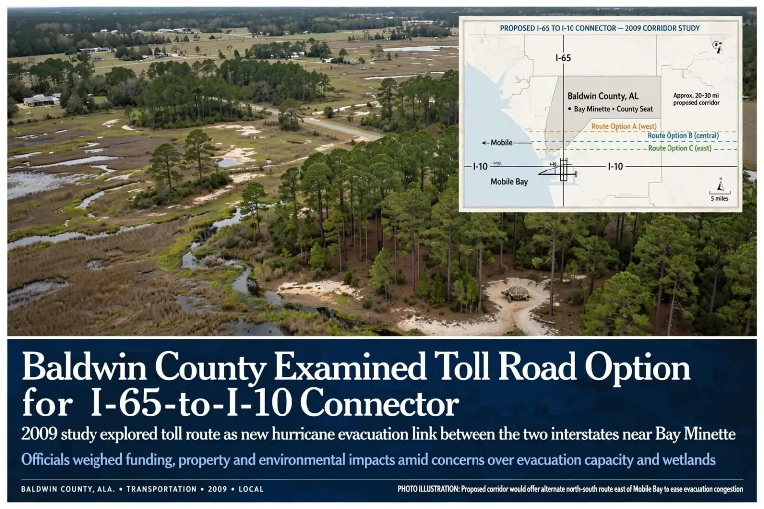
BALDWIN COUNTY, Ala. — Baldwin County transportation officials explored a potential toll road in 2009 as one option for building a new north-south connector between Interstate 65 and Interstate 10.
The proposed highway was intended to provide another hurricane evacuation route for Baldwin County. Officials were considering three possible routes near Bay Minette, and residents living near those corridors raised concerns about traffic, property impacts and environmental effects.
The idea reflected a long-standing vulnerability. Baldwin County sits wedged between Mobile Bay and the Gulf, with Interstate 10 carrying evacuation traffic west toward Mobile — across the George Wallace and Jubilee Parkway tunnels and bridges — in every serious hurricane threat. Planners had warned for years that the county’s limited number of north-south arteries could strand residents during a mass evacuation, and a direct link between I-65 and I-10 east of Mobile Bay was promoted as a way to give evacuees a second way out that bypasses the Mobile River crossings entirely.
Funding a Major Connector
The proposed 20- to 30-mile route was estimated to cost nearly $300 million. Baldwin County sought federal funding, but officials said a toll road was among the alternatives being studied if that funding did not materialize.
Cal Markert of the Baldwin County Highway Department said the county was investigating several approaches to pay for the project.
The discussion reflected the scale of the proposed connection and the difficulty of funding new transportation capacity during a period of limited state and local resources.
A $300 million price tag dwarfed what a county with Baldwin’s road budget could fund on its own, which is why the funding conversation ranged so widely. Federal earmarks, state highway dollars, toll-backed bonds and public-private partnerships were all on the table in that era of transportation planning, and toll roads in particular were drawing renewed attention nationwide as fuel-tax revenues stagnated and construction costs climbed. A toll connector, its supporters argued, could be built faster because the people who used it would finance it — while critics countered that a toll on an evacuation route would discourage precisely the residents it was meant to serve.
Property and Environmental Concerns
Residents near the proposed routes said the highway could run close to homes and through private land. One landowner raised concerns about wetlands and protected gopher tortoises on property that could be affected by a route.
Those concerns were not incidental to the planning; they were central to it. Northern Baldwin County is laced with wetlands, creeks and longleaf pine habitat, and the gopher tortoise — a species protected under Alabama law — burrows in the sandy uplands that happen to be the easiest ground for a highway right-of-way. Any route chosen would require environmental review, wetland permits and mitigation, each of which adds time and money to a project already straining for funding.
Property owners along the three candidate corridors faced the classic dilemma of a proposed highway: years of uncertainty over whether their land would be taken, depressed sale prospects in the affected zone, and the prospect of eminent domain proceedings if the project advanced. Highway departments typically hold public meetings at this stage precisely to surface those conflicts early, and the comments gathered — about traffic, noise, drainage, wildlife and family land — become part of the record that shapes the final alignment or kills the project outright.
The competing priorities were clear: officials wanted an additional evacuation link and better connectivity between the two interstates, while nearby residents wanted the county to account for the effects on land, traffic and wildlife.
Why Baldwin County Wanted the Connection
The geography explains the urgency. Baldwin County’s population had been climbing for decades, with growth radiating from the Eastern Shore communities of Fairhope, Daphne and Spanish Fort and from the beach towns along the coast. Most of that growth funnels daily traffic onto I-10 and U.S. 98, both of which choke at rush hour and both of which converge on the same few Mobile Bay crossings. A new north-south road near Bay Minette — the county seat, sitting between I-65 and the county’s growing southern population centers — would give drivers an alternative and give planners a second evacuation spine.
Hurricane history framed the debate. Hurricanes Ivan in 2004 and Katrina in 2005 had tested the region’s evacuation capacity within a single year, and Ivan in particular had hammered Baldwin County directly. Emergency managers had long identified the bottleneck at Mobile Bay as the region’s weakest link, and the connector idea circulated among county and state planners for years precisely because of it.
The toll-road study of 2009 captured all of these threads at once: a genuine transportation need, a financing problem with no easy answer, and a set of local objections that any alignment would have to answer. It was a snapshot of the region’s transportation debate in miniature.
The Broader Transportation Context
In 2009, transportation agencies everywhere were rethinking how large projects get paid for. The federal stimulus program was directing new money toward “shovel-ready” infrastructure, and states were increasingly open to tolling and partnerships with private concessionaires after decades of relying almost exclusively on fuel taxes. Alabama, with one of the lowest gasoline tax rates in the nation at the time, had limited capacity to fund major new corridors from its own road fund, which made external funding or toll-backed financing practically a requirement for any project on the scale of the Baldwin connector.
Toll roads also carried a proven track record nearby. Alabama had already built toll facilities on the Foley Beach Express, the privately operated toll bridge that carried beach traffic across the Intracoastal Waterway in southern Baldwin County, demonstrating that residents of the county would pay tolls when the alternative was congestion. That example was frequently cited in debates over whether a new connector could support its own financing through tolls.
At the same time, the recession was suppressing traffic growth and travel nationwide, and skeptics questioned whether any new toll road in the region could attract enough paying drivers to service construction debt — a question that had soured public-private toll projects in other fast-growing Sun Belt metros. For a county commission weighing endorsements and study dollars, the risk analysis cut both ways.
How Connector Studies Typically Proceed
A corridor study of the kind Baldwin County was conducting in 2009 generally moves through defined stages: defining the need, screening broad corridors, narrowing to specific alternatives, evaluating environmental impacts, and only then pursuing design, right-of-way acquisition and construction. Each stage can take years, and most proposed connectors never reach construction; they die in the funding gap between a completed study and a financed project.
The three routes near Bay Minette under discussion in 2009 would each have had to clear that full gauntlet — public hearings, environmental documentation, property acquisition and a funding plan — before a single mile of pavement could be laid. That reality is why the county’s 2009 exploration, like similar studies across the state, emphasized financing options: a corridor without a funding mechanism is a map, not a road.
This article records the 2009 proposal and funding discussion. It does not state whether a particular route was ultimately chosen or whether the toll-road option advanced beyond the early planning stage.
For residents of northern Baldwin County, the episode left a durable mark regardless of outcome: property owners along the studied corridors spent years uncertain about their land, and the community gained a detailed preview of the trade-offs any future connector — toll or otherwise — would have to resolve between mobility, financing and the environment.
Emergency planners describe evacuation capacity in terms of clearance time — how long it takes to move the population of a threatened area out of harm’s way. For Baldwin County, clearance time has always been hostage to the same geography: virtually every evacuation route to the west crosses Mobile Bay on I-10, while routes to the north are limited to a handful of two-lane and four-lane state highways that were never designed to carry a county’s worth of traffic plus the trans-Gulf evacuees from Florida’s panhandle funneled up the same roads. A connector between the two interstates would, in principle, split that load and give north-bound evacuees a direct path to I-65 without doubling back through congested interchanges.
The study years also coincided with rising awareness of how evacuation behavior actually works. Research after Gulf Coast hurricanes showed that many residents leave late, that household evacuation decisions are made car by car rather than region by region, and that clearance estimates rise sharply when evacuees from multiple counties share the same corridors. Those findings strengthened the case for redundancy — more routes, in more directions — and kept projects like the Baldwin connector alive in planning documents even when funding remained out of reach.
Local officials framing the 2009 discussion were careful to describe the toll road as an option rather than a plan. That distinction mattered: corridor studies exist to keep alternatives open and to qualify projects for future funding windows, and being able to show a completed need study and route analysis is often what makes a project eligible when federal or state money becomes available. County officials were, in effect, buying the county a place in line.