Spanish Fort Hosts Final Public Forum on Proposed I-10 Mobile River Bridge
Spanish Fort's 5 Rivers Delta Resource Center hosted the final public hearing on the proposed $850 million I-10 Mobile River Bridge project this week.
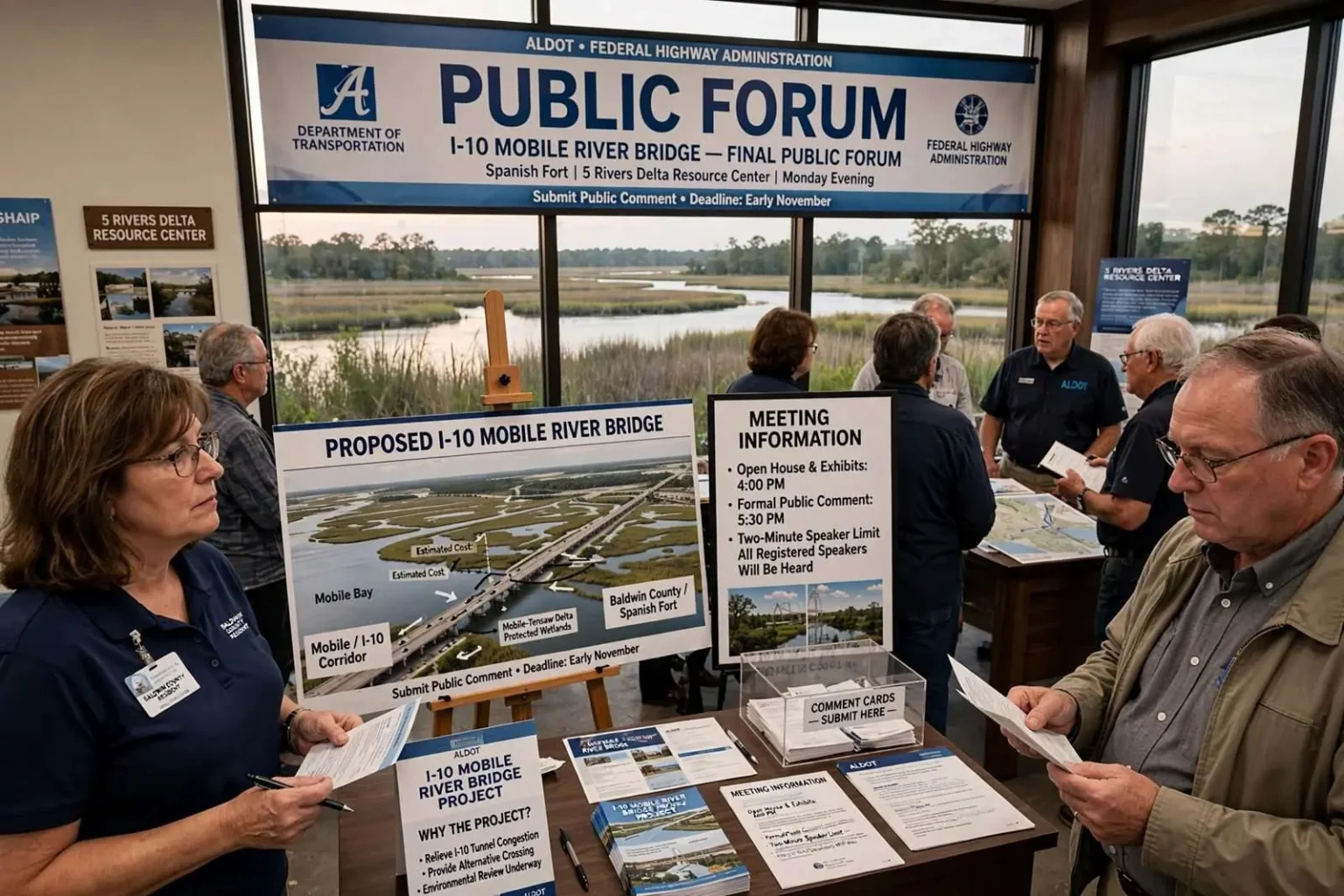
Residents who want to speak in person before state and federal transportation officials about the proposed bridge over the Mobile River had one last opportunity Monday evening in Spanish Fort. The Alabama Department of Transportation, working alongside the Federal Highway Administration, held its second and final public forum on the long-discussed I-10 bridge project at the 5 Rivers Delta Resource Center. The venue sits along the eastern shore of Mobile Bay in Baldwin County, giving residents on that side of the bay a convenient chance to weigh in on a project that would ultimately connect to the existing interstate corridor across the Mobile River.
The meeting capped a two-part public process that had already drawn hundreds of participants on the Mobile side of the bay, and it gave Baldwin County residents a session of their own before the record of public comment closed. For a project that has been discussed in the region for decades, the evening represented the moment when the conversation moved from planning offices into the open, with ordinary commuters, business owners and waterfront interests all invited to speak on the record.
How the Meeting Was Run
An ALDOT spokeswoman said the Spanish Fort session would follow the same format used at an earlier meeting held at the Alabama Cruise Terminal in Mobile, which lasted about an hour and a half and attracted more than 300 attendees. Exhibits illustrating what the proposed span — estimated to cost roughly $850 million — might ultimately look like were on display starting at 4 p.m., with the formal comment period beginning at 5:30 p.m. Officials said the forum would continue for as long as necessary to let every registered speaker have a turn, with each speaker given a two-minute window.
The open-house format with exhibits before formal comments has become standard practice for major highway projects, allowing attendees to study maps and renderings and question project staff one-on-one before speaking publicly. The two-minute limit keeps meetings manageable when speaker lists run long, while the commitment to stay until every registered speaker has been heard signals that officials intend to capture the full range of opinion rather than cut off debate at a set hour.
The 5 Rivers Delta Resource Center, on the Causeway at the mouth of the Mobile-Tensaw Delta, is itself a reminder of what the project touches. The center showcases the delta’s wetlands and waterways, the same environment that any new crossing of the Mobile River must be designed to protect. Choosing the venue put Baldwin County attendees minutes from home — and put the project’s environmental context literally in the room.
A Project Decades in the Discussion
The proposed bridge has been one of the most closely watched infrastructure projects along the Interstate 10 corridor connecting Mobile and Baldwin counties, with area residents, business owners and commuters voicing a range of opinions on everything from the bridge’s footprint to its potential effect on local traffic patterns and the surrounding waterfront. The estimated price tag of roughly $850 million makes it one of the largest single transportation investments ever contemplated in south Alabama. The numbers behind it explain the urgency: I-10 funnels interstate commerce and daily commuters alike through the narrow bank of tunnels beneath the Mobile River, where congestion is a daily fact of life.
Trucking companies, port interests and coastal commuters all have stakes in the outcome. A new crossing would give through-traffic an alternative to the tunnels, freeing capacity for local trips — or, critics caution, shifting noise and traffic toward new neighborhoods. The waterfront questions are equally weighty: a high-level bridge rising over the Mobile River would alter a skyline shaped by its low riverfront profile, and businesses downtown and along the Causeway have pressed for details about how construction and operation would affect access.
The Spanish Fort meeting gave Eastern Shore residents in particular a chance to raise concerns specific to their side of the bay before the formal comment period closes and the project moves into its next phase. Baldwin County’s explosive growth in recent decades has made the eastern approach to the bay one of the busiest corridors in the state, and Eastern Shore communities stand to feel the bridge’s traffic effects first.
What Happens After the Comment Period
Although Monday’s session marked the last scheduled in-person hearing, the public comment window on the bridge project remained open for several more weeks, with a final deadline in early November. After that point, responsibility shifts to state and federal planners, who must weigh the public input alongside engineering and environmental findings before settling on a preferred corridor and beginning detailed design work. Officials noted that no final design could move forward until an environmental impact study addressing the public’s concerns was completed, with that study expected to wrap up by the end of the year.
The environmental impact statement is the federal government’s central tool for evaluating major infrastructure projects. Under the National Environmental Policy Act, an EIS must document a project’s effects on everything from wetlands and water quality to historic resources, air quality and community impacts, and it must consider reasonable alternatives — including, in many cases, the alternative of building nothing. The document becomes the legal foundation for federal approvals, and public comments submitted during the review period must be addressed in the final statement.
That structure gives the November deadline real weight. Comments received before the cutoff become part of the administrative record that planners and federal reviewers must work through; comments that arrive later carry no formal standing. Once the EIS is finalized and a preferred corridor is selected, the project advances into detailed design, right-of-way acquisition and, ultimately, construction — stages at which the broad public influence of the comment period gives way to engineering decisions.
How to Submit Comments Without Attending
For residents who could not attend in person, ALDOT outlined several other ways to weigh in. Comment sheets could be filled out at the meeting itself or submitted through a dedicated project website expected to go live later in September. Comments could also be faxed to ALDOT’s Southwest Region office, emailed directly to project staff, or mailed to the region engineer’s office in Mobile ahead of the November deadline.
The range of channels reflected a deliberate effort to reach commuters and residents who work evenings, lack internet access, or simply prefer paper. Written comments carry the same formal weight as spoken ones — each becomes part of the project record for the environmental review — so officials encouraged anyone with a view on the bridge to submit it in writing even though both hearings had passed.
Project staff suggested that specific, detailed comments are the most useful to planners. A note identifying a particular neighborhood, waterway, intersection or business concern gives the study team something concrete to analyze and respond to, whereas general support or opposition is recorded but harder to act upon. Residents weighing what to write had the exhibits and renderings from the two public meetings as common reference points.
Anyone who missed both public forums but still wants a voice in the process was encouraged to submit written comments through any of the available channels before the November cutoff, after which the public comment period tied to the environmental review will formally close.
Why the Crossing Matters to the Region
The bottleneck at the Mobile River is more than a local inconvenience. Interstate 10 is the principal east-west artery of the Gulf Coast, linking Florida’s Panhandle, south Alabama, Mississippi and Louisiana, and every through-vehicle between those markets must cross the Mobile River at Mobile. The existing tunnel crossings, built generations ago for a far smaller region, now constrain both commuters and freight, and backups routinely stretch for miles in both directions during peak hours and hurricane evacuations.
Mobile and Baldwin counties together anchor one of the fastest-growing regions on the Gulf. Baldwin County’s population growth has outpaced nearly every county in Alabama for years, filling the Eastern Shore communities of Daphne, Spanish Fort and Fairhope with commuters who cross the bay daily. Mobile’s port, aerospace operations and industrial riverfront put heavy trucks on the same corridor. The proposed bridge is the state’s answer to the arithmetic of that growth — and the public forums are where residents get to interrogate it.
The stakes reach beyond transportation, too. A new crossing shapes future development patterns on both sides of the bay, influences downtown Mobile’s connection to its riverfront, and determines how the region handles the evacuation traffic that every hurricane season raises. Those are the kinds of questions the environmental study is designed to address, and the ones residents raised Monday evening at the delta resource center.
From Comment Cards to Concrete
For ALDOT and the Federal Highway Administration, the two forums and the written comment period serve a dual purpose: they satisfy the legal requirements of the environmental process, and they give planners the local knowledge that maps and models miss. Residents know which neighborhoods already flood, which intersections fail on school mornings, and which waterfront views define the city’s identity — details that surface most reliably in public meetings.
The timeline laid out at the meeting sets the course for the project’s next year: comments through early November, an environmental impact study complete by year’s end, a preferred corridor selection, and then detailed design work. Each stage narrows the project from concept toward construction, and each stage is harder to revisit than the last. That is why officials pressed attendees — and every resident who could not attend — to participate while the record was still open.
Monday’s meeting at 5 Rivers marked the end of the in-person chapter of a process that has been years in the making, but not the end of the public’s role. The written comment window gives the region one more chance to shape a crossing that will stand over the Mobile River for generations, and the early-November deadline is the last door before the engineers and planners take over. Residents of Mobile, Baldwin County and beyond who want a say in what rises over the river were urged to use it.