University of South Alabama Mobile County
Five Years Later, Mobile Bay Still Feels the Weight of the BP Oil Spill
Five years after the Deepwater Horizon disaster, coastal Alabama scientists and residents reflect on how the oil spill changed Mobile Bay's waters.
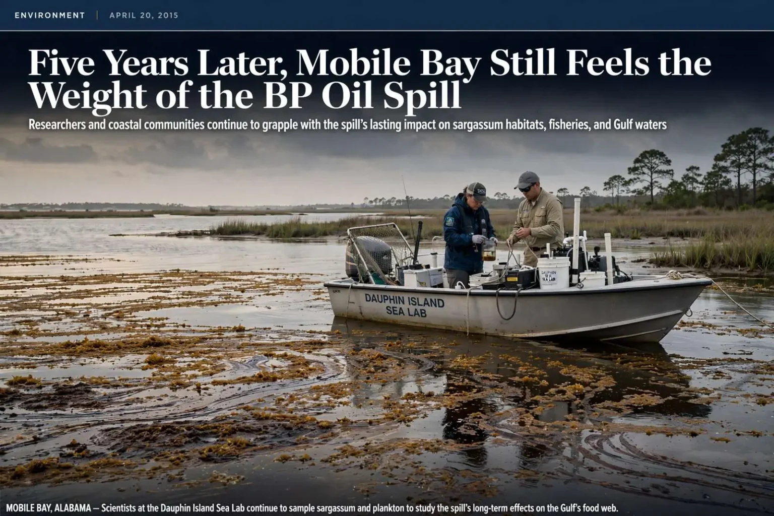
Five years after an offshore drilling rig exploded and unleashed the largest marine oil spill in U.S. history, longtime Gulf Coast residents and scientists are still piecing together what the disaster meant for the waters off South Alabama. The April 2010 explosion aboard the Deepwater Horizon rig killed 11 workers and triggered a blowout that pumped crude into the Gulf of Mexico for months before the well was finally capped. For coastal Alabama, the disaster began as a distant column of smoke on the horizon and gradually became an economic, ecological and emotional presence that shaped daily life from Dauphin Island to the Florida line.
In the spill’s early weeks, Alabama’s beaches saw little visible oil beyond scattered tarballs, even as neighboring Louisiana’s coastline absorbed thick mats and long ribbons of crude. The contrast had more to do with wind and current than with luck. Prevailing winds and loop-current eddies steered much of the floating oil west and toward the Mississippi River delta, sparing Alabama’s beaches the worst of the early impact while leaving the state’s offshore waters directly in the slick’s path. Tourism officials along the Gulf still watched booking cancellations pile up as national coverage of the spill kept visitors away, whether or not oil had reached a given stretch of sand.
But the calm was deceptive. Residents reported headaches and rashes they attributed to airborne chemicals, even as the visible slick remained offshore, driven by winds and currents that determined which coastlines would be hit hardest and when. Health questions lingered long after the visible signs of the spill faded, with cleanup workers and coastal residents alike raising concerns about the effects of prolonged exposure to crude oil and the dispersants sprayed over the water. Air monitoring stations along the coast recorded elevated readings at various points during the summer of 2010, fueling anxiety in communities downwind of the response effort.
Local boat captains and outdoor writers who traveled offshore to see the spill firsthand described eerie, glass-calm seas broken by rafts of dead fish and birds, with acres of rust-colored oil spreading across the water’s surface as the slick crept closer to Alabama’s shoreline throughout the summer of 2010. Charter fishermen who had worked the Gulf for decades reported that areas which had always held fish suddenly did not, and that dolphin and seabirds were gathering in strange places, apparently pushed around by the oil and the response activity. For a coastal economy built on access to the water, the images from offshore were a warning of what was at stake.
Sargassum: A Nursery in the Crosshairs
Much of the concern centered on sargassum, the floating seaweed that serves as a nursery for young marine life throughout the Gulf. The golden-brown mats drift with the currents and provide food and shelter in an otherwise open ocean, making them one of the most productive habitats in the region. Marine scientists at the University of South Alabama warned early on that oil moving into sargassum fields could devastate a habitat supporting everything from larval crabs and shrimp to young yellowfin tuna, effectively threatening an entire generation of Gulf species before they had a chance to mature.
The worry was not just that oil would coat the seaweed, but that the spill had arrived at precisely the time of year when Gulf species were spawning. Spring and early summer are peak spawning months for many of the commercial and recreational species that define the region’s fisheries, meaning eggs, larvae and juvenile fish were concentrated in surface waters exactly where the oil was spreading. A single bad season could echo through a fishery for years, as one weak year class works its way through the population of a species that takes years to reach harvestable size.
Researchers from the Dauphin Island Sea Lab spent the spill season pulling plankton trawls through affected waters, documenting the tiny, easily overlooked marine life caught in the crosshairs of the disaster. The Sea Lab, based on the eastern end of Dauphin Island, has long served as the region’s hub for marine science education and research, and its faculty and graduate students were among the first to systematically sample the spill’s impact on the base of the food web. Their trawl surveys captured larval fish, crabs and shrimp drifting through oiled waters, building a record that would otherwise not exist for a life stage of Gulf species few people ever see.
That kind of baseline science mattered enormously in the years that followed. Under the Natural Resource Damage Assessment process, the trustees charged with making the public whole for environmental injuries had to document what was harmed and by how much, and the early sampling done by university and Sea Lab researchers fed into that record. The work also helped shape years of subsequent restoration funding aimed at rebuilding coastal habitat around Mobile Bay and the barrier islands, money that flowed from settlements and penalty funds tied to the spill.
Restoration Money Flows to Coastal Alabama
Today, much of that restoration money continues to fund oyster reef rebuilding, marsh restoration and water quality monitoring across coastal Alabama, work tied directly to settlement funds tied to the spill. Federal legislation passed in the years after the disaster directed the bulk of the civil penalties paid by the responsible party back to the Gulf states, giving Alabama a multi-year stream of dedicated money for ecological and economic recovery. County panels, state agencies and the federal trustees responsible for natural resource damages have each steered portions of that funding toward projects in Mobile and Baldwin counties.
On the ground, the results include restored oyster reefs in Mobile Bay, rebuilt marsh shorelines along the bay’s tidal fringes, and expanded monitoring that tracks water quality from the Mobile-Tensaw Delta to the barrier islands. Oyster reef restoration has been a particular priority, both because reefs provide habitat for fish and because a living reef buffers shorelines from waves and erosion. Marsh and seagrass projects aim to rebuild the nursery grounds that sustain blue crabs, shrimp and the forage fish that larger species depend on, directly addressing the kind of damage scientists feared during the spill itself.
The five-year mark also arrived as the legal and financial aftermath of the spill was still being resolved. A record settlement covering federal and state claims was reached in the summer of 2015, locking in the largest environmental damage award in U.S. history and giving Gulf states certainty about the money available for restoration in the decades ahead. For coastal Alabama, the guarantee meant that projects planned in the chaotic years immediately after the spill could finally move from concept to construction, with local governments and conservation groups competing for a share of the funding.
What Scientists Still Do Not Know
Scientists caution that some effects, particularly on deep-water habitats and long-lived species, may not be fully understood for decades. A cold-water coral community miles below the surface near the wellhead showed damage that researchers are still tracking, and the slow reproduction cycles of species such as red snapper and marine mammals mean population-level effects can take years to reveal themselves. Sediments on the deep seafloor around the well site still carry chemical fingerprints of the spill, making the Gulf floor a long-term study site for oceanographers studying how deep-water ecosystems recover from a disaster of this scale.
Near shore, the picture is more encouraging but still incomplete. Fish populations that scientists feared would collapse largely held on, and landing records for many Gulf fisheries have rebounded to levels that surprised researchers. Yet biologists note that recovery on paper does not answer every question, particularly for species whose young depend on surface habitats like sargassum or whose migrations carry them repeatedly through waters affected by the spill. Long-term monitoring, funded in part by the settlement money, is designed to catch delayed effects that short studies would miss.
How the Spill Changed the Coast
The disaster also changed how the Gulf Coast prepares for the next one. The response exposed gaps in spill planning, from the availability of boom and skimming equipment to the science available to decision-makers in real time, and both industry and government have since invested in new response capacity and research. A decade-long science program funded as part of the spill’s aftermath put hundreds of millions of dollars into oceanographic research and built a body of knowledge about oil transport, dispersants and ecosystem effects that simply did not exist before 2010.
The spill left its mark on the region’s economy as well as its ecology. Charter boats sat idle during the worst months, seafood was tested before it could be sold, and businesses from Dauphin Island to Gulf Shores spent a summer fielding cancellation calls from customers who assumed the entire coast was coated in oil. Claims funds and tourism grants tied to the spill helped plug the gaps, but the season demonstrated how quickly a perception problem could do as much economic damage as the oil itself.
For many who lived through that summer along Mobile Bay, the anniversary remains a reminder of how quickly an environmental disaster hundreds of miles offshore can reshape daily life, local economies and the long-term health of the Gulf’s coastal waters. Five years later, the water looks normal and the restaurants serve local oysters again, but the memory of that summer — and the restoration work it set in motion — remains part of the fabric of coastal Alabama.