

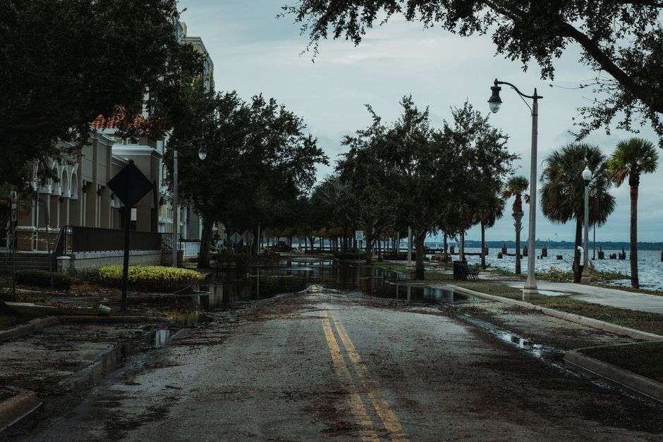
Tropical Storm Bertha is causing road and facility closures across South Alabama as the system moves through the area, with floodwater overtaking well-traveled routes in Mobile County and forcing officials to shut down key connections into the city. This list reflects the impacts reported so far and will be updated as additional closures are announced.
The Alabama Department of Transportation says all lanes of Dauphin Island Parkway are shut down at Dog River because of flooding on the roadway. The closure cuts one of the area’s principal routes to the island communities and leaves commuters and residents searching for detours as water covers the pavement near the river crossing.
ALDOT has also closed the ramp connecting the eastbound lanes of the Causeway to the I-10 Bayway, cutting off that route for drivers heading into Mobile. The ramp closure pushes traffic back onto alternate paths at a moment when heavy rain is already slowing movement across the region, and drivers who rely on the Bayway for their daily commute are being urged to plan for significant delays.
Flooded Roads on Dauphin Island
On Dauphin Island itself, Seahoy Road was covered by floodwater for much of Wednesday, forcing drivers to turn around as conditions worsened. The island’s low elevation makes it among the most flood-prone spots in Mobile County whenever a tropical system pushes water and rain into the area, and streets that sit just a few feet above normal tide levels can disappear under water in a matter of hours.
Town leaders said preparation efforts helped limit problems and continued to urge people to stay off flooded roads. Island officials typically move quickly during tropical events — pre-positioning equipment, alerting residents and monitoring the causeway connections that are the community’s lifeline to the mainland — and the town’s message during Bertha’s passage was consistent: the water on the roadways is deeper than it looks, and no errand is worth the risk.
That warning carries particular force on barrier islands, where flooded roads can hide washed-out pavement, displaced debris and currents strong enough to float a vehicle. Emergency responders across the Gulf Coast repeat the guidance every season — turn around, don’t drown — because most hurricane and tropical storm deaths in inland and coastal areas alike come from vehicles entering floodwater, not from wind.
Cedar Point Pier Closed
In Mobile County, officials closed Cedar Point Pier on Wednesday, July 22, and said it will stay shut down until conditions improve, according to a county news release. The pier, which extends into the waters at the county’s southern edge near the mouth of Mobile Bay, is a popular fishing spot that sits squarely in the path of storm-driven waves and surges.
Closing the pier before conditions peak is standard practice for coastal facilities. Storm surge and wind-driven waves can tear decking loose, damage pilings and scatter debris across access points, and a structure that juts out over open water is no place for the public once conditions build. County officials said the reopening will follow improvements in the weather and an assessment of the facility’s condition.
The closure list that accumulates during a tropical event like Bertha gives residents a snapshot of how the region absorbs a storm’s impacts. Road departments shut flood-prone segments, municipalities secure piers and parks, and each closure signals where the water has won — at least temporarily — against the infrastructure that ties the coast together.
What Tropical Storms Do to the Gulf Coast
Tropical storms often get less respect than hurricanes, but along the northern Gulf their rain and surge are what residents actually experience most. A system does not need Category 3 winds to flood streets, strand drivers and close schools; it needs only to park over the region and rotate bands of heavy rain onshore for hours at a time. Storm-track forecasts get the headlines, but the flood gauge readings are what close the roads.
The geography of the Mobile area makes it especially exposed. The city sits at the head of Mobile Bay, ringed by rivers and delta channels that drain a vast watershed, and every tropical system that drops rain on the region raises the level of the waterways that thread through the county. Dog River, which flows into the bay’s western shore, is one of the tidal streams whose flooding repeatedly cuts Dauphin Island Parkway during coastal events.
The Causeway, the low-lying U.S. 90 route across the top of the bay, has its own long history with storm water. Running just feet above the water at its highest points, the parkway and its connecting ramps are routinely affected when the bay rises, which is why closures like the one ALDOT announced come as little surprise to drivers who have watched previous storms push water across the route.
Baldwin County faces parallel risks on the eastern shore, where low-lying communities around the bay and the delta contend with rising water as the storm passes. The advisory to drivers in both counties — seek alternate routes and watch for standing water — reflects how broadly a tropical storm’s rain bands can spread impacts, well beyond the shoreline.
Driving Safely During the Storm
Local officials and safety agencies emphasize a short list of rules during tropical events. Do not drive through standing water of any depth; it takes surprisingly little moving water to lift a car and sweep it downstream. Watch for road-closed barriers and treat them as final. Slow down in rain — standing water causes hydroplaning long before it looks dangerous. And report flooded roadways rather than attempting to cross them, so crews can mark the hazard before someone else finds it the hard way.
Residents along the affected corridors are also encouraged to monitor official channels rather than relying on word of mouth. Closures during a storm evolve by the hour: a route that is passable at dawn may be underwater by afternoon, and a closure announced in the morning can be lifted once water recedes. The list of impacts in this report will be updated as conditions change and new closures are announced.
For people who live along the closed segments, the closures are more than an inconvenience. Dauphin Island Parkway communities rely on the route for access to schools, work and services, and when it floods at Dog River, drivers head north and around, adding time to every trip and load to the detour routes. The Causeway ramp closure has similar ripple effects, pushing Bayway-bound traffic onto remaining approaches at rush-hour volumes.
Preparation Pays Off
Dauphin Island leaders’ assessment that preparation limited problems is the quieter story inside every storm report. Sandbags staged in advance, drain ditches cleared, boats secured and residents informed — those steps do not make the news the way a flooded road does, but they determine how quickly a community recovers. The town’s message pairing that progress with a renewed warning to stay out of the water reflects the balance every coastal government strikes during an event: acknowledging what went right while insisting the danger has not passed.
County and state crews will keep working through the storm’s aftermath as well. Once Bertha moves on, the same roads that closed for flooding will need to be checked for washouts and debris, the pier will need an inspection before it reopens, and standing water will linger in low spots long after the rain ends. The region’s routine with tropical systems is familiar: hunker down, report the water, and wait for the roads to surface again.
Drivers in the Mobile and Baldwin County area are urged to seek alternate routes around the affected areas and to watch for standing water on area roadways as the storm continues to move through the region. Updates on the closures listed here will follow as officials announce them.
Tracking the System
Bertha’s passage is being monitored by the National Weather Service office serving the Gulf Coast, which issues flood warnings, wind advisories and tornado possibilities for the region’s counties as bands move through. Tropical systems in the Gulf frequently spin up brief tornadoes in their rain bands, adding one more reason officials want residents indoors and off the roads while the storm is overhead.
Tide gauges along Mobile Bay and the coastal waterways provide much of the real-time picture during events like this one. When winds pile water into the bay and its tributaries, the gauges show how high the water has climbed and whether it is still rising, information that feeds directly into decisions about when closed roads can be reopened and when evacuated areas are safe again.
The pattern of closures reported during Bertha follows the map that long-time residents know by heart. Dauphin Island Parkway at Dog River, the Causeway approaches, low roads on the island itself and waterfront facilities like Cedar Point Pier — the same geography surfaces in nearly every coastal flood event, which is precisely why the closures come quickly and why officials treat them as routine rather than alarming.
After the Water Recedes
The days after a tropical storm bring their own cautions. Floodwater that covers a road can leave silt, oil and hidden damage behind; utilities restore power to neighborhoods where downed lines may have been submerged; and standing water becomes a breeding ground for mosquitoes within a week. Health officials routinely advise residents to avoid contact with floodwater, which carries whatever the streets and ditches have washed into it.
Insurance questions surface quickly, too. Residents with flood damage are encouraged to document everything with photographs before cleanup begins, and those without flood insurance learn — as coastal residents are reminded after every event — that standard homeowner policies exclude flood loss and that coverage through the National Flood Insurance Program carries a waiting period before it takes effect.
For now, the guidance in both counties remains unchanged as Bertha works through the region: avoid the closed routes, stay out of the water, and check for updates as the list of impacts grows or shrinks with the storm’s movement. South Alabama has handled this kind of weather many times before, and the systems that manage it — from ALDOT’s road crews to the county departments watching the pier — will log this event alongside all the others that come with life on the northern Gulf Coast.