Inside the City’s Annexation Sales Pitch: Response Times, Free Garbage and $10 Million in Sales Tax
Mobile's PowerPoint case for annexing four west Mobile areas leaned on slow police and fire response times, free city services and more than $10 million a year in new sales tax revenue.
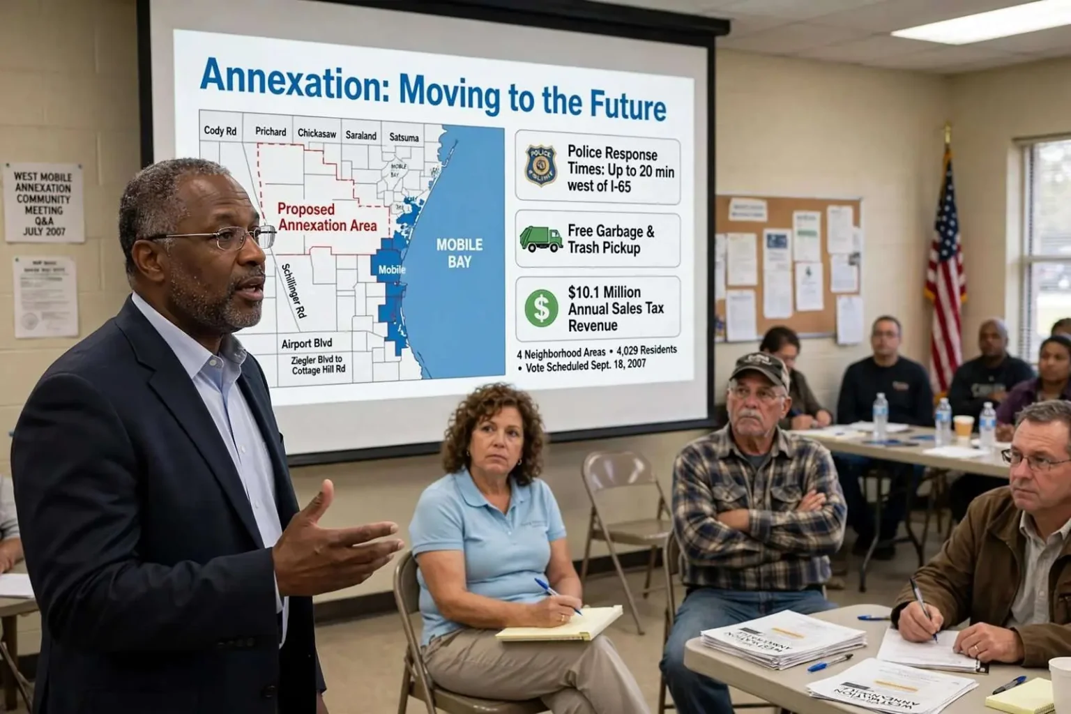
As four west Mobile neighborhoods prepared to vote on whether to join the city, Mobile Mayor Sam Jones took his case door to door and hall to hall with a PowerPoint presentation titled “Annexation: Moving to the Future.” Its 29 slides amounted to the clearest public statement of what the city believed it was offering — and what it stood to gain.
The presentation was unusual in its candor. Municipal annexation campaigns often rely on generalities — better services, civic pride — while leaving the arithmetic unspoken. Jones’s slides put the numbers on the table in both directions: what residents would pay, what the city would spend, and what the city expected to collect. That transparency became the framework for a debate that would run through the summer of 2007.
Hemmed in on three sides
The presentation opened with the Mobile skyline, then moved to an overhead map of Mobile County’s municipalities. The image made the city’s geography plain: blocked to the east by Mobile Bay and to the north by a chain of smaller municipalities, Mobile could grow only west and south.
That constraint is fundamental to how Mobile has grown for decades. The bay fixes the city’s eastern edge, and to the north, incorporated neighbors such as Prichard, Chickasaw, Saraland and Satsuma have long since claimed the territory between the city and the county line. Growth, when it comes, comes from the pineywoods and farmland to the west and southwest — which is why the map in question stretched along the city’s western flank.
The next slide showed Jefferson County, where Birmingham sits ringed by as many as 20 separate municipalities — a cautionary picture of a city that had run out of room. The comparison was aimed squarely at the annexation debate’s skeptics: a central city that stops growing becomes surrounded by suburbs that capture the growth — the shopping centers, the tax base, the jobs — and the central city is left to carry aging infrastructure with a shrinking share of the revenue that once paid for it.
The service argument
The heart of the pitch was public safety. One slide mapped average police response times across the city: strong downtown, good in midtown and north Mobile, and progressively worse west of Interstate 65, where response to incidents in the northwest and southwest approached 20 minutes.
That pattern is common in American cities: the areas farthest from station houses and patrol beats wait longest. But it also carried a particular sting in the annexation debate, because the neighborhoods being asked to vote were precisely the ones — outside the city, in unincorporated Mobile County — served by the county Sheriff’s Office rather than Mobile police. The city’s implicit argument was that the twenty-minute response times on the map showed what stretched coverage looked like, and that annexation would bring west Mobile inside a denser service grid.
Another highlighted four fire stations stretching north to south through west Mobile — Freeman, Tapia, Edwards and Cypress Shores. Against a department goal of arriving within four minutes on 90 percent of calls, the success rates cited were 39 percent at Freeman, 38 percent at Tapia, 32 percent at Edwards and 25 percent at Cypress Shores.
The numbers were presented not as a boast but as a confession of the gap between the standard and the reality. Fire response times matter in a way residents grasp intuitively — in a house fire, the difference between four minutes and ten can decide whether a family loses a kitchen or a home. The four-minute benchmark is a widely used national standard for first-due engine companies, and falling short of it on three of every four calls in the southernmost stations was the city’s strongest evidence that west Mobile needed more resources, not fewer.
The city said it had three goals in drawing the plan: neighborhood voting, a unified commercial corridor and success.
How the map was drawn
Four original study areas were laid out between Cody and Schillinger roads: Ziegler Boulevard south to Airport Boulevard; Airport south to Hitt Road; Hitt south to Grelot Road; and Grelot to Cottage Hill. A later slide showed the four voting areas as finally configured, pairing the Mobile Terrace residential area with the commercial activity along Schillinger Road and Airport Boulevard — the pairing that would become the central grievance of the plan’s opponents.
The corridor geography mattered to both sides. Cody Road, Schillinger Road and Airport Boulevard frame one of west Mobile’s principal commercial corridors, and the retail along it was the prize in the city’s revenue projections. Grouping a residential neighborhood with a commercial strip in the same voting area meant residents of the neighborhood would vote on annexation alongside businesses that stood to gain — or lose — from the switch, and opponents argued the configuration was engineered to deliver the commercial votes the city needed.
The money slide put estimated sales tax revenue from the proposed annexed areas at $10,145,140, based on 2006 collections, with business license revenue projected at another $100,000.
Those figures were the engine of the city’s argument that annexation could pay for itself. The nearly $10 million in annual sales tax from the corridor’s businesses — captured under the city’s higher combined rate once the areas joined the city — was projected to cover a large share of the service expansion’s cost. The city’s math rested on the assumption that shoppers would keep coming to Schillinger Road and Airport Boulevard after annexation rather than shifting their spending to businesses just outside the new lines.
What it would cost
The city acknowledged substantial expense. Initial capital costs were put at nearly $16 million: $2.55 million for police, almost $6 million for public works, $2.35 million for fire, and $5 million for a police and fire building and fuel depot. New recurring annual costs approached $7.5 million — nearly $3.1 million for police, including 70 new employees; $1.75 million for public works; and $2.77 million for fire, including 51 new firefighters and medics.
The staffing figures deserve attention because they represent the human scale of the expansion. Seventy new police employees and 51 new firefighters and medics are not line items that appear overnight; they require recruiting, training academies and years of payroll growth. The capital side — buildings, a fuel depot, public works equipment — reflected the physical footprint a city must build when it absorbs territory already several miles from its existing stations and yards.
Property taxes were addressed directly. The city would collect none in the annexed areas for five years. After that, a 7-mill tax would apply, meaning $21 a year on a $30,000 home, $35 on a $50,000 home and $70 on a $100,000 home.
The five-year exemption was the city’s principal concession to homeowners, and the slide translated the millage into kitchen-table arithmetic. In Alabama, a mill is one-tenth of a cent of tax per dollar of assessed value, and assessed value for owner-occupied homes is a fraction of market value — which is why the dollar figures on the slide were so modest. The pitch was that a homeowner’s added cost would be small, and deferred for years while the new services arrived.
To sharpen the comparison, one slide listed the annual cost of private garbage service then paid by residents: Waste Management, $264; Allied Waste, $297; McClure, $240; and Disposall, $252. The slide noted there was no private residential trash pickup at all — meaning brush, bulk items and junk went uncollected or depended on county programs.
The garbage comparison did the heaviest lifting in the presentation’s economics. Residents of unincorporated Mobile County paid private haulers several hundred dollars a year for basic collection; city residents received garbage, trash and debris pickup as part of municipal service. Even against the future 7-mill tax, the city’s math showed most homeowners coming out ahead — the garbage savings alone exceeding the tax bill on an average house.
The list of benefits
The city’s promised package included: free garbage and trash pickup; free street lighting and street sweeping; zoning to address junk and blighted property, with current property uses grandfathered in; a new police precinct; a new fire station staffed by 51 new firefighters and medics; paving of dirt streets and improved drainage; and improvements at the Brewer Center and a new neighborhood park.
Each item mapped to a specific complaint long associated with unincorporated west Mobile. Without zoning, junked cars and unpermitted uses sit next door to family homes with little recourse; the grandfathering clause was meant to reassure rural residents that horses, gardens and existing businesses would be protected. Dirt roads and poor drainage are chronic issues at the edge of any growing Southern city, and the Brewer Center — a west Mobile community center — anchored the neighborhood-services element of the package.
The final benefit listed was less tangible: the chance to “participate as a citizen on one of America’s great cities.” The phrasing — a small grammatical stumble preserved on the slide — captured the civic-pride argument that ran beneath the fiscal one: that the region’s identity still runs through the central city, and that residents a few miles west were invited to take part in it.
If all four areas approved, the city would gain 4,029 residents and 1,891 voters. The presentation closed as it began, on the Mobile skyline, with a single word: “Questions.”
Voters in the four areas were scheduled to decide separately on Sept. 18, 2007 — a structure that supporters called neighborhood self-determination and critics called a map drawn to guarantee the outcome the city wanted.
Annexation, Alabama-style
The September vote structure reflected how annexation works in Alabama, where state law requires approval by the residents of the territory itself rather than a decision imposed by the city council. That framework makes every annexation a genuine referendum — and makes the drawing of voting areas, and the grouping of voters within them, a matter of real strategic consequence. A city cannot simply extend its boundaries; it must persuade the households and businesses inside the proposed lines that the trade is worth making.
That is what made the 29-slide deck more than campaign material. It was, in effect, the city’s contract offer: these services for these costs, this revenue for this expense. Voters in the four areas could weigh the arithmetic for themselves — the garbage bills they paid against the taxes they would owe, the response times they lived with against the precinct and station they were promised — and the presentation’s transparency gave the debate a shared factual baseline that annexation fights rarely enjoy.
The split vote itself was the design’s most contested feature. By letting each area decide separately, the city ensured that no single area’s rejection could sink the plan — a neighborhood could decline and the rest could join. Critics read the same structure as strategic: the residential area paired with the commercial corridor was the linchpin, and the city needed the corridor’s sales tax more than it needed any individual neighborhood’s residents. Supporters countered that the structure was the only honest one available under Alabama’s referendum-based system — residents deciding for themselves, area by area, rather than being swept in or kept out by a larger block vote.
What the episode left behind was a template. The deck’s structure — geography, service gaps, revenue, cost, benefits, then the question — has defined how Mobile and cities like it present annexation proposals since: lead with the map, show the service math, put the money on both sides of the ledger, and let the neighborhoods vote. The 2007 west Mobile campaign remains a case study in how much an annexation fight is really about: not just boundaries, but who pays for fire stations, who gets a twenty-minute response and who gets to call the region’s largest city their own.