Severe thunderstorm threat continues east of I-65
A severe thunderstorm threat continued east of I-65 with damaging winds, hail and a possible brief tornado.
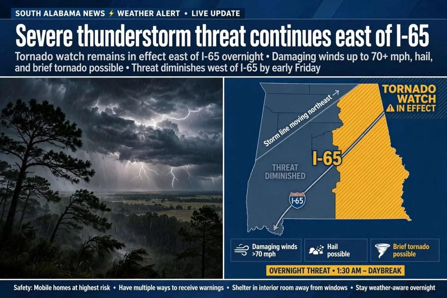
The tornado threat had ended for the area by early Friday, but strong thunderstorms continued with some severe weather still possible east of Interstate 65. The line of storms that had kept South Alabama watching the sky through the previous day was pushing out of the region, and forecasters described a diminishing but not yet finished threat for communities on the eastern side of the interstate.
A tornado watch remained in effect east of I-65, while the threat was lower west of the interstate. The storms were expected to move through overnight and be gone by daybreak, a timeline that meant the final hours of the event would unfold in darkness — the conditions under which severe weather is most dangerous, because warnings arrive while families are asleep and visual confirmation of a storm is impossible.
Forecasters warned that a severe thunderstorm could still produce damaging winds in excess of 70 mph, hail and a brief tornado. They urged residents, especially those in mobile homes, to have a safety plan with multiple ways to receive warnings and to take shelter in an interior room away from windows.
The I-65 line as a weather divide
Interstate 65 runs diagonally across South Alabama, and it frequently functions as a rough dividing line in severe weather events. Storm systems tracking northeastward out of the Gulf often carry their greatest energy east of the interstate, where instability from Gulf moisture lingers longest, while areas west of the line cool and stabilize earlier as the system departs. Meteorologists with the National Weather Service office serving the region use that geography in their briefings, and residents who live along the corridor learn to pay attention when a watch or warning map splits the area along the interstate.
The pattern in this event — the tornado threat ended to the west, watch still active to the east — is a familiar late-stage configuration for Gulf Coast storms. As the squall line exits, the atmosphere west of the track loses the warm, unstable air that feeds severe storms, while communities east of I-65 remain under the gun for another few hours. That does not mean the western side is entirely safe; damaging straight-line winds can occur behind the main line. It means the concentrated tornado risk has shifted and narrowed.
Watches, warnings, and what each requires
The distinction between a tornado watch and a tornado warning shapes what residents should do, and forecasters repeat it in every event. A watch means conditions are favorable for tornado development over a broad area and a window of hours — the time to review a plan, charge phones, and know where to shelter. A warning means a tornado has been detected by radar or spotted on the ground, and it demands immediate action in the specific areas in its path. This event’s configuration, with a watch in effect east of I-65 and the tornado threat otherwise ended, placed residents in the watch category: stay informed, be ready, and act instantly if warnings follow.
Damaging winds in excess of 70 mph, which forecasters flagged as the primary remaining threat, are capable of the kind of destruction many residents underestimate. Straight-line winds at that speed can snap shallow-rooted pines — abundant across South Alabama — peel roofs, and topple trees onto homes and vehicles. Wind damage from a squall line often covers a far wider area than tornado damage, which is why severe thunderstorm warnings deserve the same urgency as tornado warnings, not a lower grade of attention.
The mobile home risk
The emphasis on mobile home residents reflects one of the most consistent findings in severe weather safety research. Mobile and manufactured homes perform poorly in extreme winds, and a disproportionate share of Alabama’s tornado and severe wind fatalities over the decades have occurred in them. South Alabama has one of the highest concentrations of manufactured housing in the state, particularly in the rural communities east of Mobile, which makes this warning segment a recurring priority for emergency managers in the region’s counties.
The advice to those residents is specific: identify a sturdier shelter option before the storm arrives — a site-built home of a family member or neighbor, a community shelter, or a public building — and leave the mobile home when a warning is issued for the area. Sheltering in the interior room of a mobile home offers little protection against winds of the magnitude forecasters described. Emergency managers recommend making that arrangement part of the plan in advance, since the decision must be executed in minutes when a warning drops.
Forecasters urged residents to maintain multiple ways to receive warnings — a phrase that carries hard lessons from past events. Cell phones deliver Wireless Emergency Alerts and app-based notifications, but cellular networks fail in storms, batteries die, and a phone on silent mode is easily slept through. A NOAA Weather Radio with battery backup and a tone alert remains the standard recommendation because it operates independently of the cellular network and wakes its owner when a warning is issued for the county. Television and radio coverage, social media feeds from the National Weather Service office, and outdoor sirens each cover part of the picture, which is the point: no single channel is reliable enough on its own during an overnight event.
Overnight storms and the shelter plan
The timing of this event — storms clearing by daybreak but active through the night — is the scenario emergency managers dread most. Overnight tornadoes are disproportionately deadly across the South, partly because residents are asleep and partly because the region’s housing stock and storm climatology combine badly: storms that strike at night in communities with many site-built homes without basements and many manufactured homes. The National Weather Service office in Mobile and county emergency management agencies have invested in repeated public education on this exact scenario, urging families to decide tonight where they will go before a warning sounds.
The interior room guidance — lowest floor, fewest walls, no windows — applies to most homes in the region, since basements are rare in South Alabama construction. Closets, bathrooms, and hallways at the center of a house are the standard refuges, ideally with shoes, helmets, and a way to communicate after the storm passes. Families with children should rehearse the route in daylight; the middle of a warning is the wrong time to explain where the safe room is. For residents west of I-65, where the tornado threat had already ended, the same plan applies to the lingering severe wind risk, which can arrive with little visual warning of its own.
Hail and the edge cases
The hail mention in forecasters’ warnings covers a threat that ranges from nuisance to destructive in a single storm. Small hail damages gardens and awnings; large hail — the kind severe thunderstorms can produce in a Gulf Coast squall line — shatters windshields, dents vehicles, and strips roofs, generating insurance claims that linger long after the sky clears. Residents were advised to move vehicles under cover where possible before the line arrived and to stay away from skylights and windows during the storm itself.
The phrase “brief tornado” in the forecast reflects the spinning storms that form along a squall line’s leading edge. These are typically fast-moving, lower-end tornadoes compared to the long-track violent tornadoes of spring outbreak events, but brief does not mean harmless — a small tornado crossing a mobile home park or a highway at highway speed does catastrophic local damage. Radar detects the rotation, but the warning-to-impact interval can be minutes, which is why the watch-stage preparation forecasters emphasized matters more for these storms than for any other.
What the morning brings
By daybreak, forecasters expected the system to be gone from the area entirely, leaving behind the usual post-storm assessment: downed trees and power lines, scattered outages, and local reports of wind damage that crews would work through the morning. Residents emerging after an overnight event are advised to treat downed lines as energized, report outages rather than approaching damaged equipment, and photograph damage for insurance before temporary repairs begin.
Events like this one follow a rhythm Gulf Coast residents know well: days of forecast discussion, a watch as the line organizes, warnings as it moves through, and a morning of cleanup once it exits. The margin between a routine wind event and a deadly one is usually measured in the preparations made before dark — the charged phone, the weather radio, the plan for the mobile home household, the shoes by the closet door. Forecasters’ final advice as the storms moved east of I-65 was to hold those preparations through the night and let the warnings, not the hour, decide when it was safe to sleep soundly again.