
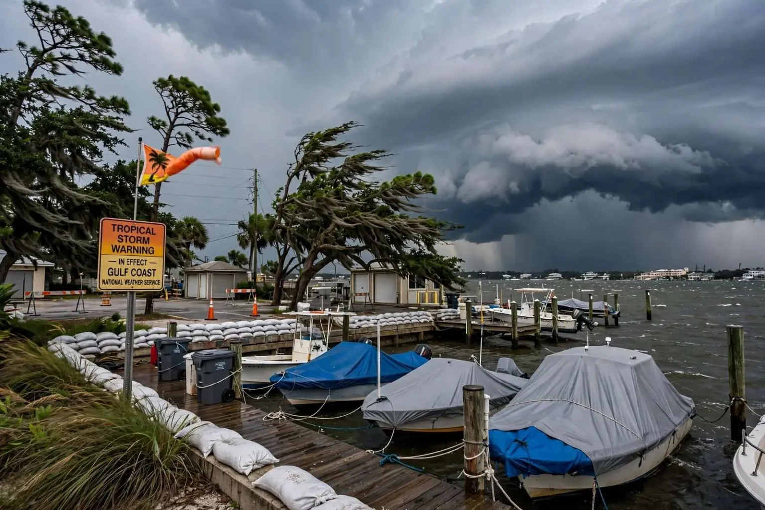
Tropical Storm Warning Covers the Gulf Coast
MOBILE, Ala. — A tropical storm warning has been issued for the Gulf Coast as Potential Tropical Cyclone 16 approaches the area. The alert prompted some local events to be canceled. Residents across south Alabama and the Gulf Coast should monitor the system, secure outdoor items and stay tuned to local forecasts for updates on watches, warnings and any additional cancellations.
The issuance of a tropical storm warning is the moment a storm stops being something to watch and becomes something to prepare for. It means forecasters expect tropical storm conditions — sustained winds of 39 miles per hour or higher — in the warned area, generally within 36 hours. For the cities and towns that line the northern Gulf Coast, from Mobile Bay to the Florida panhandle, that timeline sets the clock for everything that follows: securing property, adjusting plans and deciding when it is time to get off the roads.
Potential Tropical Cyclone 16 is the designation forecasters give a system that has not yet fully organized into a named tropical storm but that poses a threat and needs a warning product for the public. The label allows the National Hurricane Center to issue watches and warnings before a defined center of circulation forms, which matters most when a system is closing in on land. For coastal residents, the practical meaning is simple: the disturbance is close, conditions are expected to deteriorate, and the window for preparation is open now.
What a Tropical Storm Warning Requires
The standard advice issued with every Gulf Coast warning is familiar because it works. Secure outdoor items — patio furniture, trash cans, grills, anything that wind can turn into a projectile. Check generators and fuel before the rain arrives, charge phones and battery banks, and gather a few days of water, food and medications in case power is out for days. Residents in flood-prone areas, from low-lying coastal neighborhoods to the creeks that drain inland, pay particular attention to rainfall totals, because water is historically the deadliest product of Gulf storms — not wind.
Local governments activate their own checklists in response. Public works crews clear storm drains and stage equipment, police and fire departments review staffing for the height of the weather, and emergency management agencies move into regular briefings with the National Weather Service office that serves the region. School systems and event organizers weigh the same forecast and decide whether to close or cancel, and the warning’s arrival prompted some local events to be canceled, as organizers chose not to have crowds and equipment exposed to deteriorating conditions.
South Alabama’s vulnerability to tropical systems is a matter of geography. The Gulf of Mexico’s warm waters feed storms as they approach, and the gently sloping coastal plain means storm surge can push water well inland along Mobile Bay and the rivers that feed it. Even systems that come ashore far from Mobile bring widespread tree damage here: the region’s mature pines and oaks, standing in soft, rain-soaked ground, come down across power lines in nearly every significant wind event, which is why outages — not wind damage to structures — are usually the longest-lasting impact.
The Gulf Coast’s Long Memory of Storms
Residents of the central Gulf Coast prepare for warnings like this one with a history most of the country does not share. Hurricanes Frederic in 1979, Ivan in 2004, Katrina in 2005 and Sally in 2020 each left deep marks on the region, and every household that lived through them carries a personal checklist learned the hard way. The memory shapes behavior: generators are serviced at the start of hurricane season, trees near homes are watched, and when a warning is issued, many families simply execute a plan they have kept in mind for years.
The National Weather Service office in Mobile is the forecasting backbone for this response, issuing the watches and warnings, tracking radar returns and updating local officials through the course of the event. Its forecast discussions translate the Hurricane Center’s big-picture track into specific expectations — wind speeds by area, rainfall totals, surge guidance for the bay and its tributaries — that residents and local governments act on. Staying tuned to those local forecasts, as the warning urged, is the surest way to know when conditions will arrive and when they have passed.
Power crews and utility companies are the other standing army of a Gulf Coast storm. Alabama’s utilities pre-position line workers and mutual-aid crews before landfall, because restoring electricity across a rural, tree-dense service area takes days, not hours. Residents who keep those days in mind — with cash on hand for out-of-service registers, full tanks of gas and plans for refrigerated medications — ride out the aftermath far more comfortably than those who wait to see what happens.
Communication is the final piece of the preparation routine. Families agree on how they will check in if cell service degrades, and residents are reminded that text messages often get through when voice calls fail on congested networks. Battery radios, which still receive National Weather Service broadcasts, remain one of the most reliable sources of information when internet and television are out. Charging every device before the rain begins — phones, tablets, laptop computers and portable batteries — has become as automatic as filling the bathtub in households that have been through Gulf storms before, and it costs nothing but a few minutes of foresight.
Cancellations and Community Adjustments
The human side of a tropical storm warning shows up in a thousand small decisions. Church suppers are postponed, high school games are moved or scrapped, festivals close their gates, and municipal meetings are rescheduled. Some local events were canceled as the warning took effect, and more changes typically follow as the system’s track sharpens. Organizers who act early avoid the worst outcome — crowds caught out as conditions arrive — and residents are encouraged to check with event sponsors before traveling anywhere the storm’s approach could disrupt.
Schools make parallel decisions. Districts across south Alabama monitor the forecast and coordinate with emergency management, sometimes dismissing early, sometimes closing outright, depending on timing and expected conditions. Buses on rural routes and teenage drivers are the priorities that drive those calls, and parents have learned to expect notification as soon as a warning is issued rather than waiting for the morning of.
On the water, the warning has an even more immediate meaning. Boaters secure vessels or move them upriver, marinas haul out what they can, and commercial traffic on Mobile Bay adjusts to the port’s storm protocols. The bay’s fishing fleets and the pleasure boats that fill its marinas have been through this routine before, and the hours after a warning is issued are when that work gets done — long before the first squall line arrives, when handling lines and cranes is still safe.
After the Wind, the Water
Forecasters repeat one message above all others with Gulf storms: the danger does not end when the wind dies down. Rain that falls inland takes days to drain through the coastal plain’s rivers and creeks, and flooding along the Mobile, Tensaw and Tombigbee systems can continue long after skies clear. Roads that look passable may hide washed-out shoulders, and the standing advice — turn around, don’t drown — exists because floodwater claims drivers who misjudge its depth every season.
Cleanup brings its own hazards. Downed power lines can remain energized, and generators run in garages or near windows send carbon monoxide into homes every storm. Chain saw injuries and falls from ladders fill emergency rooms in the days after a wind event, which is why agencies pair their storm warnings with after-the-storm guidance: treat every downed line as live, run generators outdoors and far from the house, and take the slow jobs slowly.
For now, the region’s task is the one the warning lays out: monitor the system, secure outdoor items, and stay tuned to local forecasts for updates on watches, warnings and cancellations. Potential Tropical Cyclone 16’s approach put south Alabama and the Gulf Coast on notice, and the warning gives residents the timeline to get ready. The coast has made this preparation countless times, and it will make it again — the routine, repeated well, is what turns a threatening system into a survivable inconvenience.
Updates on the system, on school and event decisions, and on any change in the warning’s scope will come from the National Weather Service and local officials as the storm develops. Residents should rely on those official sources rather than rumors, verify cancellations before traveling, and check on elderly neighbors once the immediate preparations are done. A community that prepares together rides out the storm together — and recovers together after it passes.