West End of Dauphin Island Sees Flooding Ahead of Hurricane Michael
The west end of Dauphin Island is seeing early flooding as Hurricane Michael approaches, with strong winds threatening roads and utilities.
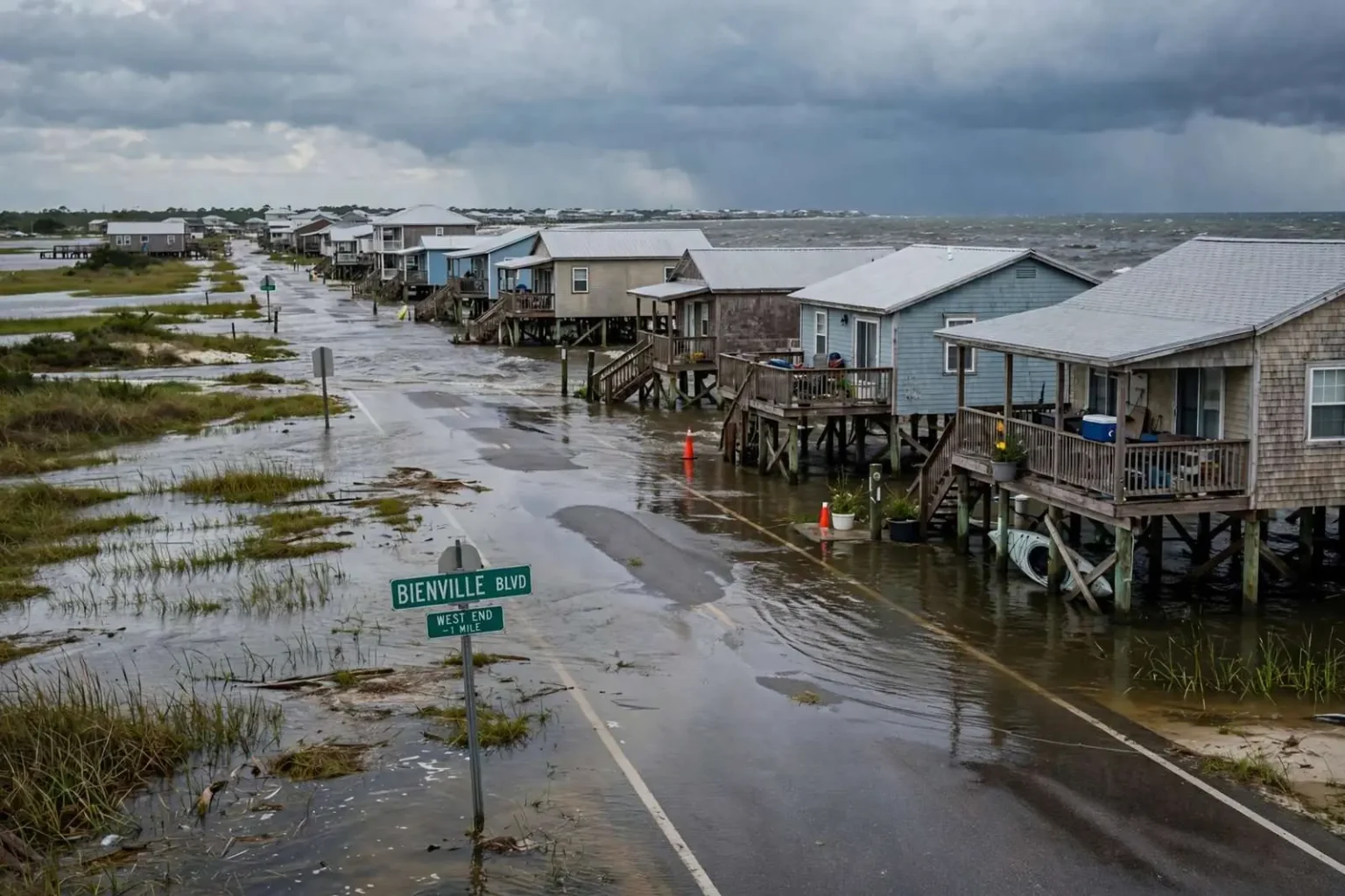
DAUPHIN ISLAND, Ala. — The west end of Dauphin Island is already seeing low-level flooding well ahead of Hurricane Michael, driven by strong westerly winds and higher-than-normal tides that are pushing water across the low-lying stretches of the barrier island even though the storm remains well offshore.
The early flooding underscores a pattern residents of the town know well: the island’s west end typically bears the brunt of tropical systems that approach the northern Gulf Coast. Unlike the larger, higher eastern end of the island, which is anchored by Fort Gaines and the ferry landing, the western stretches are narrow, low, and dotted with homes on stilts, leaving them exposed to water pushed in from the Gulf and the sound on either side.
Mayor Jeff Collier said that if Michael tracks further east, the island may avoid some of the flooding that has plagued residents and vacationers there in recent storms. The town’s exposure depends heavily on the exact path of a storm and the direction of its winds, with westerly blows driving water down the length of the island and piling it against the west end’s beaches and roads.
Michael’s approach comes in the same year the island has already been through one tropical event. Earlier in the season, Tropical Storm Gordon brought flooding to the area, soaking streets and low-lying lots on the west end even though the system made landfall well to the west of the island. Last year, another tropical system piled sand high onto roads across the west end, including the main thoroughfare, Bienville Boulevard, leading to months of cleanup before the road network was fully cleared and restored.
A Barrier Island Built for Storms — and Vulnerable to Them
Dauphin Island sits at the mouth of Mobile Bay as one of the northern Gulf Coast’s principal barrier islands, and its two halves behave very differently in a storm. The eastern end rises on higher ground and holds most of the town’s permanent infrastructure, while the west end is a long, narrow spit where the elevation is measured in a few feet above the tide line. That geometry is why water from even modest tropical systems reaches the western streets before conditions deteriorate anywhere else.
Westerly winds are the classic trigger for the flooding pattern now being observed. When sustained winds blow out of the west or southwest, water is driven along the length of the island’s sound side and across the west end from multiple directions at once, combining with the already-elevated tides to push shallow water over roads and into yards. The flooding is often not deep, but it is persistent, cutting off access to homes and keeping residents out until the water recedes.
Higher-than-normal tides compound the effect. When an onshore wind pattern coincides with astronomical high tides, the water has nowhere to go but across the island’s lowest ground, and the flooded stretches can remain impassable through multiple tide cycles before conditions ease.
Utilities on the West End Are Part of the Calculus
Collier said the town also hopes to avoid having to shut down water and sewer service on that end of the island because of the storm. Preemptive utility shutdowns are a standard tool for barrier island communities when a major storm threatens: taking lines offline before floodwater arrives prevents contamination and reduces damage to pumps and lift stations, but it also means homes on the affected end are without service until the system can be safely restarted.
For the town, avoiding a shutdown is more than a convenience. Water and sewer infrastructure on a low-lying barrier island is expensive to repair, and each storm that forces a shutdown brings costs and downtime on top of the damage the flooding itself causes. The town’s preference, officials have indicated in past storms, is to keep service running as long as conditions allow and reserve shutdowns for situations where the infrastructure itself is genuinely at risk.
Michael arrived late in the 2018 hurricane season as a rapidly strengthening storm in the eastern Gulf, a track that kept south Alabama communities in the watchful zone between direct impact and the worst of the weather even as beaches and islands along the coast dealt with the storm’s peripheral effects — high surf, elevated water, and wind-driven flooding like that already visible on the west end.
Rental Community Braced for the Storm
On an island where much of the west end housing stock is rented out to vacationers, storm preparation falls heavily on the local realty companies that manage the properties. Local realty company ACP was checking on vacation renters to make sure they knew how to stay safe and had parked vehicles on higher ground, part of the standard playbook rental managers follow when tropical weather threatens the island.
The vehicle guidance matters for a practical reason. West end streets flood early and often in tropical systems, and cars left at street level can be stranded or damaged by water that is only inches deep. Renters who park on higher ground — or leave the island altogether when officials advise it — spare themselves the loss of transportation at exactly the moment it would be most needed.
For visitors, the days before a storm’s arrival are the window in which decisions get made. Vacation rentals on the west end are popular through the fall, and guests who have never experienced Gulf Coast tropical weather depend on property managers and town officials for direction on when to leave, where to park, and what to expect as conditions change. Realty staff working through their guest lists ahead of Michael were carrying out that routine contact, confirming that everyone on the island for the week understood the situation and had a plan.
A Season of Repeated Blows
The 2018 season has been an active one for the island, and the flooding already underway ahead of Michael comes on top of a year of repeated water events. Gordon’s flooding earlier this year soaked the west end with much less warning than a hurricane provides, a reminder that on a barrier island a weaker storm with the wrong wind direction can still close roads and flood yards.
The sand deposited by last year’s storm presented its own kind of disruption. When surge and waves wash across Bienville Boulevard, they leave behind tons of sand that must be hauled off or pushed back before the road can carry normal traffic. The months-long cleanup that followed was a visible reminder of the difference between flooding that simply recedes and the physical reshaping a stronger system can leave behind.
Access and Evacuation Realities on the Island
Everything about storm response on Dauphin Island runs through a single road connection to the mainland, which shapes how the town prepares. With one causeway link serving the island, residents and visitors who plan to leave need to do so before flooding begins, and conditions on the west end can cut off neighborhoods while the road to town remains dry. The east end’s higher ground also serves as the practical refuge for vehicles and equipment that cannot be moved off the island, which is why property managers and officials direct west end renters to relocate cars and valuables east or inland rather than ride out the water where it stands.
The pattern also affects the town’s recovery math. When flooding is limited to the west end, crews can begin clearing and assessing while the rest of the island functions normally; when a storm covers the whole island, the same cleanup stretches over a much longer period. The months of sand removal after last year’s system showed how much recovery time a single widespread event can consume on a community of this size.
What Residents Watch as the Storm Approaches
As Michael closed on the northern Gulf Coast, west end residents were tracking three things: the storm’s track, the wind direction, and the tide. A further-east track would take the strongest winds and the heaviest surge toward the Florida panhandle and away from the Alabama barrier islands, easing the flooding threat. A westerly or southwesterly wind field over the island, by contrast, keeps water moving against the west end regardless of how far the center stays offshore.
The town’s officials have long made the same basic appeal ahead of every system: west end property owners and renters should take the flooding seriously even when forecasts look favorable, secure or relocate vehicles and low-lying property, and be prepared for west end roads to become impassable before the worst of the weather arrives. The water already moving across the island’s western streets ahead of Michael made the point without any further urging.
Town crews and utility staff were monitoring conditions as the storm approached, with the decision on water and sewer service for the west end resting on how the flooding progressed. For a community that has absorbed Gordon this year and a sand-burying storm the year before, the hope, as Collier indicated, is simple — that Michael tracks east, the water stays manageable, and the island is spared another round of cleanup and repair.