Mobile Residents Weigh In on Plans for Citywide Greenway Trail
Organizers are holding planning meetings this week for a proposed trail system linking Mobile's waterfront, downtown and Municipal Park.
A coalition of nonprofit, business and community leaders is beginning to map out an ambitious vision for Mobile: a connected system of walking and biking trails stretching from the city’s waterfront through downtown and out toward Municipal Park. The Mobile Greenway Initiative is spearheading the effort, with the proposed Crepe Myrtle Trail forming a key piece of the broader plan, and organizers are determined that residents themselves will shape how the routes ultimately take form.
The trail would run along the western edge of Mobile Bay, cutting through the Mobile Aeroplex at Brookley before eventually reaching downtown near Interstate 165, with improvements to Three Mile Creek included as part of the vision. If completed as imagined, the system would link some of the city’s most historically significant and most overlooked landscapes — bayfront industrial land, the creek corridors that drain the city, and the neighborhoods between them — into a single continuous path for walkers, runners and cyclists.
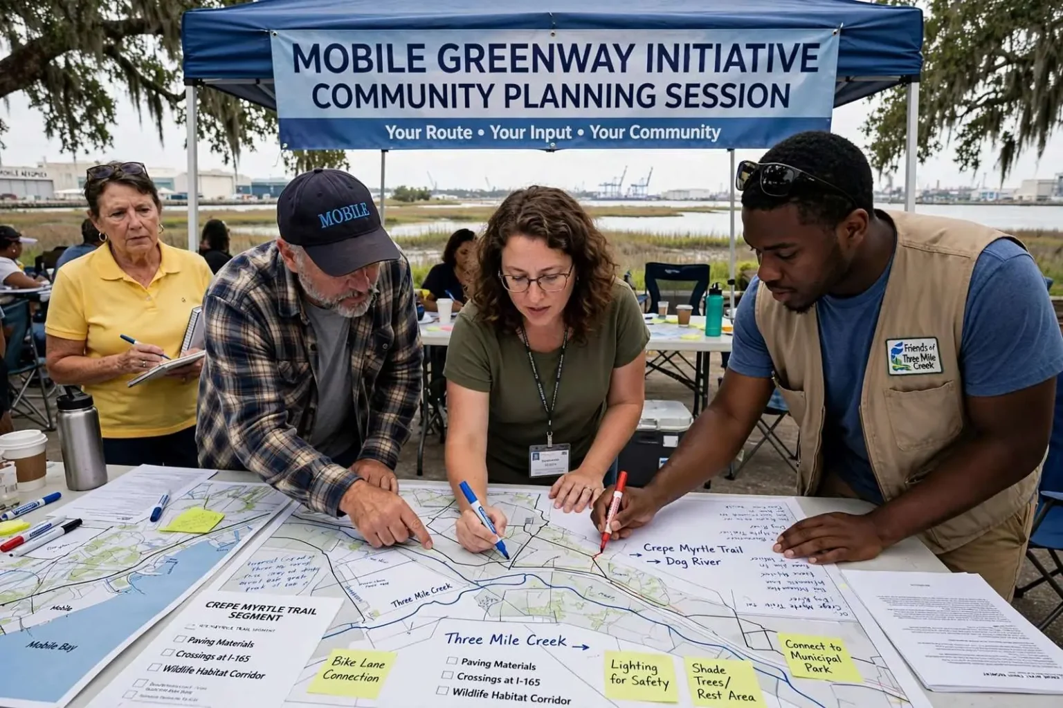
This week, organizers held planning meetings inviting residents to help shape the route, encouraging attendees to suggest new loops, connections and amenities that could be built into the trail’s design as it develops. The sessions are structured as working meetings rather than lectures: maps on tables, markers in hand, and an open invitation to mark up the routes with ideas for where the path should run, what should sit alongside it and what local features deserve to be highlighted.
A dedicated planning session for the Crepe Myrtle Trail segment, which would connect Three Mile Creek to Dog River for cyclists and runners, drew community members interested in the project’s direction. That segment alone would give west Mobile a continuous off-road route between two of the area’s best-known waterways, a link that residents have discussed in one form or another for years.
An idea decades in the making
The concept of a waterfront trail in Mobile dates back to the late 1990s, and a portion of an earlier route has already been paved, with the existing bike path currently ending at Doyle Park. Generations of local cyclists and runners have used that stretch and wondered why it stops where it does; the current effort is, in part, an attempt to answer that question with a complete plan rather than another fragment.
Organizers held a similar bike ride last year that gave more than 100 cyclists rare access to a stretch of waterfront property near the airport, with another ride planned for next month to keep the idea in front of residents. The rides serve a dual purpose: they let people experience the land the trail would cross, and they demonstrate public enthusiasm in a form that grant reviewers and elected officials can see.
The project gained new momentum last year after Mobile United, one of the partner organizations involved, received a National Park Service grant supporting trail planning and community engagement. The grant brought in technical expertise that a volunteer coalition would struggle to fund on its own, including professional planning support for translating community wishes into buildable route maps.
A National Park Service community planner assigned to the project says his focus over the coming months will be developing a trail layout and continuing to gather resident input on details like paving materials, lighting, landscaping and safety features. Those details, unglamorous as they sound, determine how a trail actually gets used: lighting decides whether the path is practical in the evenings, surface materials determine whether road bikes and wheelchairs can travel comfortably, and crossings at busy roadways often make the difference between a route people embrace and one they abandon.
The land involved tells much of Mobile’s story. The Mobile Aeroplex at Brookley sits on the site of a former Air Force base whose closure decades ago left the city with an enormous tract of flat, open land beside the bay — acreage that has since become an industrial and aerospace anchor for the region. Routing a trail through the Aeroplex would thread public access through working infrastructure, a design challenge the planners acknowledge but also an opportunity to connect the waterfront in a way no existing street network allows.
What a connected trail system could mean
Advocates for the greenway point to a familiar list of benefits that trail projects elsewhere have delivered: safer routes for children walking to school and riding bikes, exercise opportunities accessible to residents who lack access to gyms, and a quality-of-life amenity that employers and young workers increasingly look for when deciding where to settle. Mobile’s waterfront, mild winters and flat terrain give the city natural advantages for outdoor recreation that a connected trail system would finally put within reach of more neighborhoods.
There are economic dimensions as well. Trails that link neighborhoods to commercial districts bring foot traffic to local businesses, and communities across the country have watched former rail corridors and waterfront paths become anchors for restaurants, bike shops and small-scale development. Mobile’s proposed route — touching downtown, the Aeroplex and the creek corridors — passes close to districts where that kind of steady, everyday traffic could make a visible difference.
Environmental benefits factor into the planning too. The Three Mile Creek corridor, which the broader vision would improve, has been the subject of long-running local efforts to restore the waterway and its surroundings, and trail investment tends to reinforce those goals by putting eyes and maintenance attention along the creek. Greenways also create living corridors for birds and other wildlife through urbanized land, a quiet benefit that residents notice once the path exists.
The coalition behind the effort spans nonprofits, business leaders and community organizations, a structure designed to keep the project alive through the years of grants, easements and construction phases that any trail of this scale requires. Big single-source funding for trails is rare; what works, advocates say, is a durable partnership that can assemble money piece by piece and keep the public engaged enough that the project stays a civic priority.
Organizers say a complete build-out of the trail system is still years away, and they describe the current round of meetings as the phase where the community’s fingerprints get pressed onto the plan. Residents who want a say in where the Crepe Myrtle Trail runs, what the waterfront segments look like or which connections matter most are being urged to attend the sessions, join the rides and add their ideas while the route lines are still being drawn in pencil.
For a city that has spent decades discussing how to reconnect with its waterfront, the emergence of a coordinated plan — backed by a National Park Service planner, a coalition of civic partners and a growing body of public input — marks the most concrete step yet toward turning a late-1990s idea into a path that residents can actually walk, ride and enjoy.
The geography of the proposed network rewards anyone who studies a map of the city. Mobile sits at the head of Mobile Bay, hemmed in by water to the east, wetlands to the south and a patchwork of creeks threading through the city itself. Three Mile Creek drains a broad swath of the central city before joining the Mobile River, while Dog River winds through the city’s western side toward the bay. A trail system connecting the two, with spurs toward downtown and the bayfront, would for the first time let a cyclist travel across the city without sharing a lane with cars.
Municipal Park, the northern anchor of the broader vision, has been part of previous civic planning efforts, and linking it into the network would give neighborhoods along the way a destination with restrooms, fields and shade — the practical amenities that turn a path into a place families actually go. Planners often note that successful trails are strung together by such destinations, giving walkers a reason to go farther than their own block.
Funding for the next phases will likely come from a familiar mix: federal transportation programs that support pedestrian and bicycle infrastructure, state and local grants, private donations coordinated through the partner organizations and in-kind support from agencies that own the land along the route. Each segment will rise or fall on its own financing, which is why organizers describe the effort as a multi-year, incremental project rather than a single groundbreaking.
The next organized bike ride, scheduled for next month, is expected to draw another large field of riders onto the route near the airport, and organizers hope the participants will come back to the planning tables with opinions about what they saw. Every public session adds to the record of resident input that grant applications require, and every rider who experiences the potential route firsthand becomes another advocate for finishing what the city started in the 1990s.