Storms Knock Out Power for Thousands Across Mobile County
Strong afternoon storms cut power to thousands of Mobile County customers, with the heaviest outages reported in west Mobile, downtown and Dauphin Island.
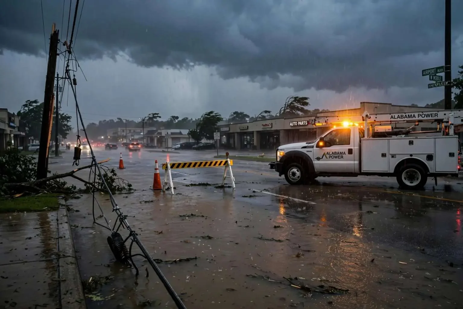
A round of strong afternoon storms rolled through the Mobile area on a Tuesday in mid-September, cutting electricity to thousands of homes and businesses as heavy rain, gusty winds and frequent lightning moved across the region. The storms arrived with little fanfare — not a named tropical system, just the kind of violent afternoon convection the central Gulf Coast produces in late summer — but they knocked out power across a wide swath of the county and turned the evening commute into a slow, water-logged crawl for drivers across west Mobile and downtown.
West Mobile Hit Hardest
An Alabama Power spokeswoman said the heaviest concentration of outages struck west Mobile, where approximately 2,000 households lost service as the storm cells pushed through. Crews with the utility were monitoring the situation closely but held off sending trucks into some neighborhoods until lightning and high winds had cleared the area, citing safety concerns for line workers. The delay is standard practice and often frustrating for customers waiting in the dark: utility crews cannot safely work energized lines with lightning in the immediate area, and the worst of the damage often cannot even be assessed until the sky clears.
Downtown Mobile was not spared either. Another 1,600 customers in the downtown area went dark during the height of the storm, and roughly 1,000 additional customers on Dauphin Island also lost power as the weather system moved through the coastal areas of the county. The spread of the outages — from the island to the central business district — illustrated how broad the storm’s reach was, with the same line of cells affecting neighborhoods separated by more than thirty miles of coastline and city.
Flooded Streets and a Snarled Commute
Photos and video shared by residents and weather watchers showed flooded roadways in parts of west Mobile, with standing water backing up along Airport Boulevard and slowing afternoon traffic to a crawl. Airport Boulevard — the main east-west artery through west Mobile — floods predictably at low points during heavy rain, and Tuesday’s storms produced exactly the kind of ponding that turns the boulevard’s clogged intersections into impromptu lakes. Drivers across the area were urged to remember the standard warning: never drive through standing water of unknown depth, which is the leading cause of flood-related vehicle deaths.
The National Weather Service office in Mobile also noted forecasters had spotted the storm cells approaching the west side of the city ahead of the worst of the rain and wind. The advance notice, delivered through radar-confirmed warnings, gave residents time to secure outdoor belongings and take shelter before conditions deteriorated, even if it couldn’t keep the lights on. September is the heart of the Gulf Coast’s convective and tropical season, and Mobile’s meteorologists stay busy through the month tracking exactly this kind of fast-developing afternoon activity.
Restoration Into the Evening
Alabama Power officials said restoration crews planned to work into the evening once conditions were safe, with the timeline for full restoration depending on how quickly additional storm cells cleared the area. The utility asked customers to report outages through its normal channels so crews could prioritize work by neighborhood. Outage reporting does more than log a complaint — each report helps the utility’s mapping systems pinpoint where the grid failed, since a single damaged feeder line can leave hundreds of homes dark while the utility knows only what its sensors show.
Restoration after a summer storm follows a familiar sequence: first the transmission lines and substations that serve whole areas, then the main distribution lines along major roads, and only then the individual service drops that connect single homes. That is why one neighborhood can be restored hours before another — and why customers at the end of a damaged line are usually last to see their power return.
Baldwin County Also Battered
The outages in Mobile County came on the heels of a broader stretch of unsettled weather that also knocked out power for thousands of customers across the bay in Baldwin County that same day, as the same storm system pushed eastward along the Gulf Coast. Utility crews on both sides of Mobile Bay found themselves stretched thin responding to scattered outages tied to downed lines and storm damage. When a single weather system spans the bay, the two utilities’ service areas are hit in sequence, and mutual-aid arrangements — crews lent from unaffected regions — become the difference between an overnight restoration and a multi-day one.
Baldwin County’s losses were a reminder of a geography lesson coastal residents know well: storms that form over the Gulf or move in from the west sweep across Mobile before they ever reach the Eastern Shore, giving Baldwin’s residents a short preview of what is coming. Tuesday’s pattern was textbook, with the cells intensifying as they crossed the bay and producing a second wave of damage in communities from Spanish Fort down to the coast.
What Residents Can Do When Storms Hit
Events like Tuesday’s outages are a good moment to revisit the basics of storm preparation on the Gulf Coast, where severe afternoon thunderstorms are a near-daily possibility from June through September. Residents should keep phones and backup batteries charged, have flashlights — not candles — ready, and know how to report an outage to their utility before the storm arrives. Homes with medically necessary electrical equipment should already be on their utility’s priority registry, and everyone should treat every downed line as live and stay far away from it.
Food safety is the other after-storm essential: a full freezer holds a safe temperature for roughly two days unopened, a refrigerator for only a few hours, and any food that has been above 40 degrees for more than two hours should be discarded. It is simple guidance, but it is the kind of thing that is easy to remember only after the power has already been out for a while.
A Pattern, Not an Anomaly
September storms of this kind are less dramatic than hurricanes but cumulatively more common, and they are the reason Gulf Coast utilities invest so heavily in vegetation management and grid hardening. Most summer outage damage comes from trees and limbs falling across distribution lines — trimming cycles, pole upgrades and smarter grid equipment all shorten restoration times when the weather turns. For residents, the practical takeaway from a day like Tuesday is simple: on the central Gulf Coast, a strong afternoon storm is not a rare event but a routine feature of the season, and the households that bounce back fastest are the ones that treated the next outage as a matter of when, not if.
By late evening, with the storm cells finally out over the bay and beyond, restoration crews had made substantial progress across west Mobile, downtown and Dauphin Island, and the region settled back into its ordinary rhythm — until the next afternoon sky darkened over the same horizon.
Counting the Cost of a Summer Storm
Storms like Tuesday’s rarely make national news, but they carry real costs for the households and businesses in their path. Spoiled groceries, lost work hours, surge-damaged electronics and the utility’s own repair bills accumulate across thousands of properties, and for small businesses — restaurants whose coolers hold a week’s inventory, salons that lose an afternoon of bookings — a single prolonged outage can erase a day’s income entirely. That is why local emergency management officials treat severe thunderstorm preparedness with the same seriousness as hurricane season, even though the storms arrive with far less warning apparatus.
The flooding along Airport Boulevard and other west Mobile corridors also renewed the perennial conversation about drainage across the county. Mobile’s low-lying topography, clay-heavy soils and intense rainfall rates make standing water a recurring problem in the same spots after every heavy storm, and the city and county have spent years working through drainage improvement projects funded by a dedicated property tax. Residents know their local trouble spots by heart, and veteran commuters build their storm-day routes around them.
Lightning, too, is a bigger hazard on the Gulf Coast than many residents appreciate. The central Gulf Coast sits among the most lightning-prone regions of the United States, and every summer afternoon storm carries the risk of fires, surge damage and injuries. The most reliable advice remains unchanged: when thunder follows lightning within thirty seconds, get indoors, stay off corded phones and plumbing, and wait thirty minutes after the last rumble before returning outside. For utility crews, those same rules govern when repair work can begin, which is why the restoration clock always starts after the weather clock ends.
For now, the sequence Mobilians know by heart had played out once again: a dark sky over west Mobile, a burst of wind and rain, thousands of homes in the dark, flooded intersections on the drive home, and crews working into the night to put things right. It is the Gulf Coast’s ordinary storm season — repeated year after year, and survivable for exactly as long as residents keep treating it that way.