Heavy Rain Flooded Part of Belforest in 2008
Archived WKRG coverage reported localized flooding in the Belforest community after heavy rain in April 2008.
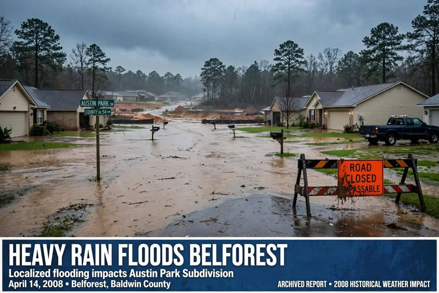
Historical weather-impact report, published from archived local news coverage. This is a historical account of a past weather event, not a current flood or travel advisory.
Heavy rain caused localized flooding in the Belforest community of Baldwin County in April 2008, according to an archived local news report. The flooding was concentrated in and around the rapidly growing community along the Eastern Shore of Mobile Bay, where a morning of persistent rain turned low-lying streets into shallow streams and left residents watching water pool where none had pooled before.
The station reported that Austin Park Subdivision off County Road 54 was underwater, with streets resembling rivers and front yards becoming ponds. Several roads in the area became impassable for a time, stranding some motorists at the edges of the flood zones and forcing drivers who knew the area to take long detours around the worst spots.
Residents said runoff from new construction sites had turned the floodwater brown and raised concerns about drainage as development expanded across the community. Although much of Baldwin County was under a flash-flood warning that morning, the station reported only minor flooding elsewhere in the county — making Belforest the focal point of the morning’s weather impacts and a case study in the growing pains of one of coastal Alabama’s fastest-changing communities.
Belforest: a crossroads community in transition
Belforest sits in the heart of the Eastern Shore growth corridor, in unincorporated Baldwin County between Daphne and Malbis, anchored by the junction of County Road 13 and County Road 64 and bisected by the traffic of County Road 181 to its east. For most of its history it was a rural crossroads — farmland, pine stands, a few churches and country stores — far from the waterfronts that put Baldwin County’s beach towns on the map. In the decade leading up to 2008, that changed almost beyond recognition.
The housing boom that swept the Eastern Shore in the 1990s and 2000s transformed the Belforest area into one of the county’s busiest construction zones. Subdivisions spread across former fields along County Road 54 and the connecting roads, drawn by the schools serving the Daphne area, the short commute to Mobile across the Bayway, and the comparatively affordable land of the unincorporated county. Each new subdivision brought roofs, driveways, and streets — impermeable surfaces that shed rainwater instead of absorbing it — and each brought the drainage questions that would surface, literally, on mornings like this one.
County Road 54, which runs west from Belforest toward the heart of Daphne, had become one of the corridor’s busiest local arterials by 2008, carrying commuter traffic toward the interstate and school traffic toward the Eastern Shore campuses. The flooding of a subdivision directly off that road put the water problem in the middle of the community’s daily circulation, visible to thousands of passing drivers and impossible for residents to ignore.
What the residents saw that morning
The images described in the archived report — streets like rivers, front yards like ponds — are familiar to anyone who has lived through flash flooding in flat coastal terrain. Baldwin County’s low relief means water has nowhere to go except where the drainage carries it, and when the drainage is undersized, blocked, or simply overwhelmed by a cloudburst, the water finds the streets instead. In a subdivision where the ditches and culverts were sized for a rural past and the rooftops of a suburban present, the math fails quickly.
The brown color of the water drew particular attention from residents. Runoff from construction sites carries sediment — bare red clay and topsoil loosened by grading — and that sediment-laden water flowing through a neighborhood is visible evidence of the development upstream. Residents’ concerns about drainage as development expanded reflected a tension that Baldwin County officials have wrestled with for decades: growth pays for schools and roads, but it also changes the way water moves across the land, and the costs of that change often land first on the neighborhoods downstream of the newest construction.
Across Alabama and the Gulf South, engineers describe the pattern as the hidden cost of impervious surface. A wooded acre absorbs a large share of a typical rain; the same acre under roofs and pavement sheds nearly all of it, and all at once. Multiply that across a rapidly built-out subdivision landscape and the ditches, culverts, and detention ponds that existed on paper can be overwhelmed in a single intense storm — precisely the kind of morning Belforest experienced in April 2008.
The flash-flood warning and the wider county
The flash-flood warning that covered much of Baldwin County that morning was the National Weather Service’s standard alert for conditions in which rapid runoff could endanger lives and property. Mobile Bay’s eastern shore sits in one of the wetter corners of the country, where Gulf moisture can produce rainfall rates that overwhelm drainage in minutes, and the weather service’s Mobile office issues such warnings for Baldwin County multiple times in a typical year. What distinguished this morning was not the warning but the location of the damage: while much of the county saw only minor flooding, Belforest’s troubles were severe enough to stand out.
Flash flooding of this kind poses specific dangers that emergency officials repeat every season. Water across a road is deeper and faster than it looks, and vehicles — even trucks — can be swept away by surprisingly shallow moving water. The roads that became impassable in the Belforest area did more than inconvenience commuters; they created exactly the hazards that prompt the standing advice to turn around rather than drive through. Impassable roads also slow emergency response, since fire, ambulance, and sheriff’s units must route around flooded stretches to reach homes on the far side.
The concentration of damage in one fast-growing community rather than across the county also illustrated how local the drainage picture can be. Two neighborhoods a mile apart can experience the same storm entirely differently depending on elevation, soil, and the condition of their drainage. For the rest of Baldwin County, the morning passed with inconveniences; for the streets off County Road 54, it was the day the water came indoors and up the driveways.
Growth, drainage, and the county’s long debate
The complaints about construction runoff placed the April 2008 flooding inside a much longer Baldwin County argument. The county has grown for decades as one of Alabama’s fastest, and the Eastern Shore corridor — Daphne, Spanish Fort, Fairhope, and the unincorporated communities around them — has absorbed a large share of that growth. County commissioners have repeatedly faced the same questions Belforest residents raised in 2008: what erosion controls apply to construction sites, who pays when new development overwhelms old drainage, and how the county plans roads and stormwater for a future that keeps arriving faster than the paperwork.
Construction-site runoff is regulated at the federal and state level through sediment and erosion control requirements, and developers typically install silt fences and retention measures during grading. But enforcement is a matter of local capacity, and heavy rain on an active site can defeat even compliant controls. Residents watching brown water pour through their streets see the failure directly, and their complaints have historically been one of the main drivers of strengthened county stormwater rules over the years.
Belforest itself continued to grow in the years after the 2008 flooding, with more subdivisions, commercial development along the county roads, and long-running public discussion of traffic and infrastructure improvements. The community’s flooding episodes have recurred as growth has continued, and each one revives the same questions raised that April morning — questions about ditches, culverts, retention ponds, and the pace of development that no single storm answers.
A historical account — and its lessons
As a historical record, the April 2008 report preserves a snapshot of the Eastern Shore at a particular moment: a community in mid-boom, a morning storm, and a subdivision underwater while the rest of the county stayed mostly dry. The details — Austin Park Subdivision off County Road 54, the impassable roads, the brown runoff from construction sites — are the kind of particulars that vanish from memory quickly but matter to anyone studying how the region’s growth and its water problems intertwine.
The practical lessons the event taught have been repeated in every flash flood since: never drive through water across a road, watch the drainage around your own property, and pay attention when new construction changes the land upstream. Baldwin County residents have heard the National Weather Service’s Mobile office issue the same warnings many times in the years since. The archived report of Belforest’s flooded streets is a reminder that the most serious impacts of a Gulf Coast storm are often not the wind or the coastline but the water — and where the water is allowed to go.