Mobile Endorsed Preferred I-10 Bridge Route in 2009
Mobile leaders endorsed a preferred route for a proposed high-rise I-10 bridge over Mobile Bay in 2009, seeking relief for tunnel and Bayway congestion.
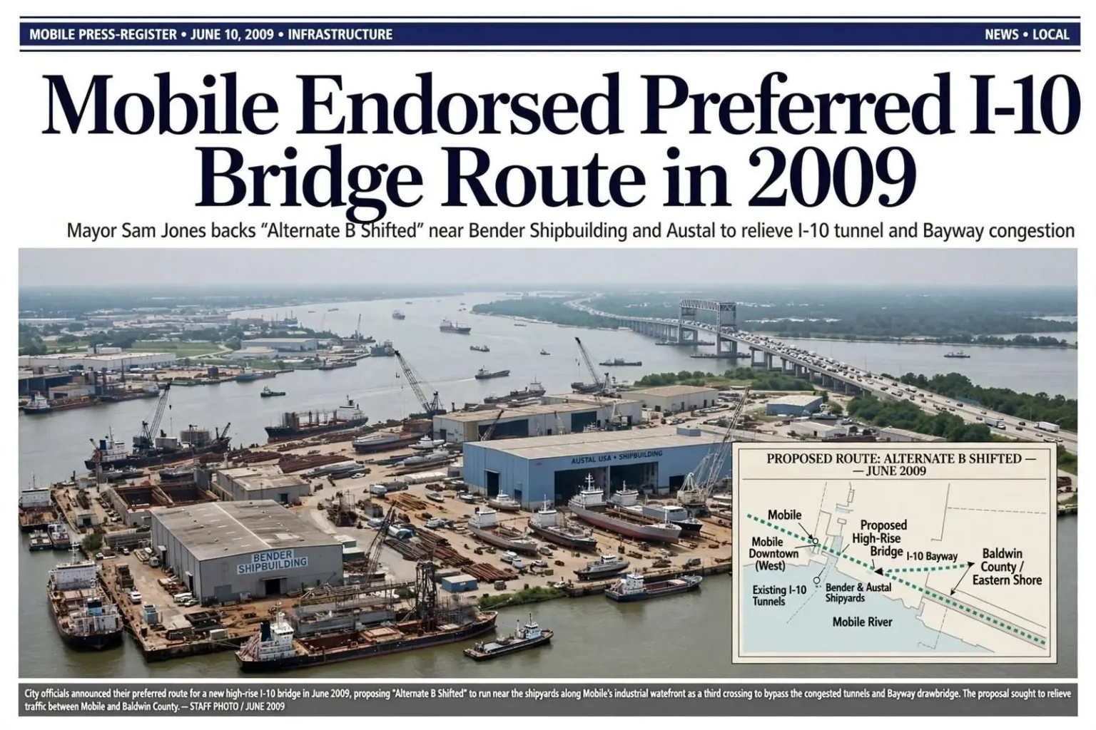
Mobile officials announced a preferred route for a proposed high-rise Interstate 10 bridge over Mobile Bay in June 2009, urging state and federal leaders to advance the project that would add a third crossing between the city and the Eastern Shore.
Mayor Sam Jones said the city favored the alternative known as “Alternate B Shifted.” The concept would have passed near Bender Shipbuilding and Austal’s shipyard before connecting to the existing I-10 Bayway bridge, threading new infrastructure between working waterfronts on the Mobile River’s eastern edge.
Transportation officials were considering 14 alternatives after receiving public comments on the proposed bridge, a list that reflected years of study about where — and whether — a new crossing should span the bay. The alternatives ranged in alignment, design and community impact, and public input had already reshaped the study more than once.
The project was intended to reduce congestion at the I-10 tunnels and on the Bayway, the jar-shaped bottlenecks where the interstate’s twin river tubes and the low-rise Bayway bridge funnel ever-growing volumes of traffic between Mobile and Baldwin County. Residents had also raised concerns about the effect of a high-rise structure on nearby neighborhoods, a tension that ran through every public meeting held on the proposal.
Why a third crossing mattered
By the late 2000s, the I-10 corridor through Mobile had become one of the Gulf Coast’s worst chokepoints. The George Wallace Tunnel and the older Bankhead Tunnel carry the interstate beneath the Mobile River in tubes built for traffic volumes that have long since outgrown them, and the Bayway’s drawbridge span — the portion that rises for ship traffic — backed up for miles during peak hours and tourist weekends alike.
The problem was compounded by freight. The Port of Mobile, the growing industrial corridor along the river, and the steady flow of beach traffic between I-65 and Florida’s panhandle all pressed on the same few miles of interstate, making the tunnels-and-Bayway stretch a daily test for commuters and a logistical headache for truckers moving cargo through one of the region’s economic engines.
A high-rise bridge, in the thinking of project supporters, would solve two problems at once: it would carry interstate traffic without the tunnel bottlenecks or the drawbridge delays, and it would open a route that could grow with traffic for decades. The price was a structure tall enough to clear the port’s shipping channel — and visible for miles across the city’s historic neighborhoods.
The city’s choice
In backing “Alternate B Shifted,” Mobile’s leadership sought a route that minimized disruption to established neighborhoods while keeping the connection practical. The alignment near Bender Shipbuilding and Austal’s shipyard placed the crossing through industrial waterfront rather than residential streets, an approach the mayor and business backers described as the least intrusive of the options under study.
Port and business leaders joined the mayor for the announcement, reflecting the importance of reliable cross-bay transportation to Mobile’s maritime and industrial economy. The chamber-aligned voices at the announcement argued that the region’s growth — Baldwin County’s population boom chief among it — would eventually force the crossing question, and that planning ahead beat waiting for gridlock to make the case.
Baldwin County’s stake was equally large. The Eastern Shore communities of Daphne, Spanish Fort and Fairhope had grown into bedroom communities for Mobile workers, and the Bayway carried that commute twice a day. Any relief for the crossing was, for Baldwin residents, relief for the most predictable frustration of their week.
Opposition, though, was never hard to find. Neighborhood groups on the Mobile side raised concerns about a high-rise structure’s footprint near historic districts, noise and traffic impacts during a years-long construction period, and the question of who would pay — tolls on a new bridge were already part of the discussion, a prospect that drew its own resistance from daily commuters.
Study, comment, revise
The 14 alternatives under consideration in 2009 were the product of an environmental review process that weighed engineering feasibility, environmental impacts on the bay and its wetlands, effects on neighborhoods and historic properties, and cost. Public comments had already reshaped the list, and each new round of meetings drew residents with maps, complaints and their own preferred alignments.
That process — alternating between technical study and public comment — is standard for a project of this scale, and it meant that no single announcement could settle the question. The city’s endorsement of a preferred route was an advocacy position within that process, not a decision, and federal and state reviewers would weigh the alternatives against criteria that went beyond any one municipality’s preference.
This report documents Mobile’s 2009 route preference. It does not mean the route was approved, constructed or selected as the final design, and it should not be read as current project information. The bridge question would continue to evolve through years of study, funding debates and revised proposals long after the June 2009 announcement.
The long shadow of the tunnel bottleneck
The 2009 announcement sits in a decades-long arc of attempts to solve Mobile’s crossing problem. The tunnels date to the 1940s and early 1970s, the Bayway to mid-century, and every generation of planners since has confronted the same geometry: a deep shipping channel, a historic downtown and an interstate that must connect two growing halves of a metro area separated by open water.
The June 2009 preference for “Alternate B Shifted” recorded where the city stood at that moment — a mayor, a port community and a business leadership aligned behind a route that traded neighborhood disruption for an industrial alignment near the shipyards. It was a snapshot of one city’s position within a regional debate that would continue in study after study.
For residents of the neighborhoods near the proposed alignment, the announcement was a call to engagement rather than a verdict. Public meetings in the years that followed drew crowds who pressed officials on noise walls, ramp locations, construction staging and the fairness of tolling, and every refinement of the proposal carried consequences someone at a microphone opposed.
What the 2009 episode illustrates about the I-10 bridge saga is how long infrastructure decisions take. Fourteen alternatives, multiple rounds of comment, shifting administrations and funding debates stretched the question across decades — a reminder that a preferred route announced one June is only one step in a process measured in years, and that today’s preferred alignment is never guaranteed to survive the next round of study.
Mobile officials’ June 2009 announcement remains part of the public record of that process: a city on the west side of Mobile Bay, led by Mayor Sam Jones, formally backing the “Alternate B Shifted” concept near Bender Shipbuilding and Austal’s shipyard, urging state and federal partners to keep the project moving toward a decision.
The geography behind the debate
Understanding the bridge debate starts with the water. Mobile Bay stretches roughly 30 miles from its narrow mouth at the Gulf to the head of the bay at the Causeway, and every crossing between downtown Mobile and the Eastern Shore must thread between the port’s shipping needs on the west and the wetlands that fringe the shoreline on both sides. A bridge tall enough for ocean-going vessels towers over anything else on the skyline; a tunnel low enough to tuck beneath the channel chokes on traffic volumes it was never designed to carry.
The existing I-10 route solves that geometry with a compromise: drive down into the river tubes, cross, then climb back onto the Bayway — only to stop, if a ship is passing, while the drawbridge span opens. On a good day the route takes minutes; on a bad one, an accident or a bridge opening turns the interstate into a parking lot visible from blocks away.
Bender Shipbuilding and Austal represented the working waterfront any new crossing would have to respect. Bender’s yard had served the port for generations with ship repair and construction, and Austal — the Australian shipbuilder that grew its U.S. operations in Mobile into a major builder of Navy and commercial vessels — occupied riverfront space that shipping channels and dry docks made effectively immovable.
An alignment passing near those yards, as “Alternate B Shifted” proposed, minimized residential takings but raised engineering questions of its own — ramp connections into a dense industrial and road network, clearances over working harbors, and construction staging in some of the busiest water on the Gulf Coast.
Reading the record carefully
For readers researching the I-10 bridge today, the 2009 announcement is best understood as one documented moment in a very long conversation. The city expressed a preference; the state continued its studies; federal reviewers weighed environmental and community impacts; and the proposals, alignments and funding plans continued to change in the years afterward.
That is why the historical record matters. Reports from each era — including the June 2009 announcement of the city’s preference for “Alternate B Shifted” — capture the debate as it stood at the time, with the alternatives, officials and concerns of that moment, and should be read as history rather than as a description of any current plan or project status.